Saturday, November 22, 2014

Cold Harbor Battlefield

Yesterday, I took a four mile hike around the Cold Harbor Battlefield.  Like several other places in Virginia, two major Civil War battles were fought here: Gaines Mill as part of the Seven Days Battle in 1862 and Cold Harbor in June 1864.  They represent Robert E. Lee's first and last major victories.  However, the Battle of Gaines Mill was a single major battle in McClellan's seven day long campaign, most of those individual battles being Confederate losses, but Lee won strategically when the Army of the Potomac retreated.  At Cold Harbor, the battle was an overwhelming Confederate victory, but Lee lost strategically when Grant swung around the Army of Northern Virginia and headed for the 10 month long siege at Petersburg that effectively would end the war.

I used my DeLorme inReach to capture my track.  The red arrows show my hiking directions, part of the walk being an "out and back."  You can see that a lot of the ground is heavily wooded, but in June 1864, most of it was open ground that led to wholesale slaughter as large armies clashed across seven miles of battle fortifications.  The battle lasted from June 1 through June 12, but the worst fighting happened on June 3.  After that, the action was nine days of miserable trench warfare in the broiling June sun.


The walk is easy - especially compared with the difficult times that the two armies had.  It goes past lots of incredibly well-preserved trenches and other earthworks that are now more than 150 years old.  It is sobering to walk in this peaceful place now and imagine what it must have been like.  Some of the Union dead, including many unknown soldiers, are buried at the Cold Harbor National Cemetery.  There were 13,000 Union and 5,000 Confederate casualties here.

The guns are silent here now - I call that a good thing!

The Garthright House was used as a field hospital as artillery shells crashed around.  The lady of the house cowered in terror in the cellar as blood from the injured men above seeped between the floorboards.

Here is one example of 150 year old trenches.  In 1862, the armies here clashed in charges across the battleground.  But two years later, one army (the Confederates) dug in as the other charged them.  This was the precursor to the awful trench warfare of World War I.

Since I was last here, they added some more trails and one of them goes past this pretty new battlefield monument, dedicated to the 2nd Connecticut Volunteer Heavy Artillery, which suffered pretty horrific losses in the state.  It is a nice thing to remember those who made such sacrifices so long ago.

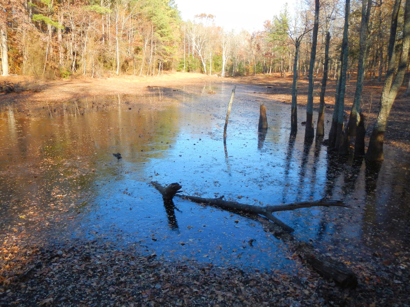
Believe it or not, most of this small pond was coated in ice!  That is really rare for Richmond in November.

These trench lines would have been totally in open land at the time of the fight, but now, a park-like forest grows around them.

This steam is named Bloody Run.  It is clear and refreshing looking now, but 150 years ago, it likely ran red with blood.  Something like 7,000 Union men fell in about 30 minutes on June 3, 1864.  One placard talked about a description of a regiment melting away like a snowfall in the summer. 

I enjoyed having the time to take a little hike on a cold Friday, and to reflect on the long-ago sacrifice by so many Americans.

Sunday, November 9, 2014

Hiking to Two Lovely Falls

It's funny how our brains play little tricks on our memory.  When I hiked the trail yesterday to Jones Run and Doyle's River, I was convinced that I hiked there almost exactly a year ago.  On checking this morning, it was actually two years ago.  I gave a very detailed account of that hike on a foggy Friday at this post, including many wildlife sightings, so I won't go into as much detail here.  Suffice to say, this is one of my favorite hikes, and it felt great to be back.  I was with my Meetup Group, Richmond / Charlottesville Adventurers, and it was nice to hike with a group of fun people who all share a common interest.  This was a particularly fun and lively group!  There were 11 of us - well, a dozen actually, as Indy, a very nice black dog, also came along.  She was pretty funny when all the snacks and lunches came out.  I always say that a dog will give its life for its companion, but let the food supply dwindle to a single morsel, and you won't stand a chance!

My hike from two years ago include an elevation profile and a map, so I won't repeat them here.  The trail loses and gains about 1,900 feet, most of the loss being in the first half and most of the gain being at the second half.  Any reasonably fit person can do this hike.  The distance of the hike is about seven miles.  My very accurate GPS captured it as 7.0 miles a year ago.  Yesterday, I didn't bring my GPS but used my new DeLorme inReach Explorer, and it captured the distance as 7.6 miles.  The both use the satellite network for the tracking, so I am not sure where the difference comes from.

Here is most of our merry little group near the Jones Run Falls.  It looks like three of us, plus Indy, missed being in this photo.  You can tell that it is fairly cool.  I am thinking that it was the upper 30's F when we started the hike.  It never got extremely warm - it is November in the mountains - but it was comfortable enough.

This is part of the Jones Run Falls, as the stream cascades through a steep mountain gorge.

Jones Run Falls was falling fast yesterday.  Note - the rocks are very slippery here.  I actually took a tumble and landed on my butt while approaching the falls.

A waterslide runs down the steep slope.

This crystal clear pool is on the Doyle's River.  All this water is headed for the Chesapeake Bay.  In one pool, two very large trout were swimming - they looked to be over a foot long!  That was the only wildlife I saw yesterday, in sharp contrast to the hike of two years ago here.

The Doyle's River Falls consist of a lower falls...

And the upper falls....

Several of us hiked up to the upper part of the upper falls, and a few even climbed the large rocky area in the background right.


Yours truly with the upper part of the upper falls at Doyle's River.

The waterfall splashes merrily over mossy rocks.

This was a really fun hike.  On the drive out, we stopped at an overlook for the view.  By coincidence, this view is the beginning of my three day hike a few years ago to Austin, Furnace, and Trayfoot Mountains.  Austin Mountain is on the right, the slope of Furnace Mountain is on the left, and Brown's Gap (our first night campsite) is in the middle.

Here's a topo map view of some of the same area, showing Brown's Gap clearly running between Furnace Mountain (foreground) and Austin Mountain (background), and also showing some of the trails.


Friday, November 7, 2014

North Anna River Battlefield Fall Hike

I had today off and had time to do an afternoon hike, so I headed to North Anna River Battlefield.  In late May 1864, as part of Grant's Overland Campaign, a desperate battle was fought here.  Now, it is a peaceful and pretty forest, although some of the original elaborate trench fortifications still are in evidence.  Here are a few photos from my 3.9 mile out and back hike.  I enjoyed reading the historical placards along the way, and flushing a family of ruffed grouse - at least six of them - on the hike back.  Since the last time I was here, they have expanded the trail system to reach the river itself, so that was nice.

At the start of the hike, there is information about the battle, and a painting of some of the bloody fighting.  The Union lost this battle, but the Army of the Potomac kept on heading south to an ever bigger defeat a week later at Cold Harbor.

The trail is nicely graded throughout.

I enjoyed reading information as the hike progressed about the battle.

I bet the soldiers who dug these would be amazed there is still evidence of their work 150 years later.  They might be even more amazed that people still care about what happened here.

Partridge berry, I think.

Fall colors are at peak here right now.  They are long gone in the mountains.


I enjoyed the fact that the trails now go all the way down to the river itself.  This was near my turn around spot, and I retraced my steps for the hike back out.