With this post, my blog is finally caught up. I did this hike November 4. It was really two separate out and back hikes, totaling about six miles. The first (red arrow) was a hike to the Shenandoah National Park border on the Turk Gap Trail. The second (purple arrow) was a hike to the summit of Turk Mountain, and its nice views across the Shenandoah Valley. Both hikes started and returned to the Skyline Drive (purple star).
It was a cool fall day, and actually cold on the summit of windy Turk Mountain. The foliage had diminished a lot just since my hike five days before in the same area. The Turk Gap hike was steadily downhill, and returning up hill. Turk Mountain, as you might guess, was pretty much the opposite. Here are some photos from Turk Gap, starting with this view of Turk Mountain - my second hike of the day - looming above.
The Turk Gap Trail was a very pleasant walk. I didn't run into any spectacular beasts or scenery, but just had a mellow walk in a pretty forest.
Lady in red...
I threw my Jet Boil in my pack, along with my mug, a tea bag, and a little honey. So I enjoyed a pleasant tea break along the trail.
This maple almost looks like flames.
Here are two more views of the trail going through the autumnal forest.
A splash of yellow with Turk Mountain in the background.
Turk Mountain has some nice views from its rocky summit. I will let them speak for themselves. These are views across the Shenandoah Valley and also of some of the mountains in SNP.
This is probably the last photo of fall foliage in the mountains I'll take in 2016 - but you never know. Now that my blog is caught up, it's time for another hike!
Thursday, November 17, 2016
Tuesday, November 15, 2016
Through the Gap and Along the River
This hike was from October 30, and is my next to last post to catch up with. It was a 9.9 mile hike in Shenandoah National Park, covering at least four trails, and it was mostly a loop. Here is the track. I started at the north end of the loop, went clockwise, did a short (a mile or so) out at back along the Appalachian Trail to the south, and then reversed direction and marched north back to the beginning at Turk Gap. It was a very enjoyable day. My goal was to reach the Calf Mountain shelter for lunch and tea, but I was running low on time and was hungry, so I stopped at the southernmost point of the hike for this, right along the trail.
I didn't see any spectacular scenery or creatures, but there was a good bit of all color that I enjoyed. Here are a few photos from my hike, now two+ weeks ago. Are you intrigued by any trail you come to, wondering where it leads? I am!
Fall colors - red, orange, and yellow.
Fall is probably my favorite time of year, but it is so short. My guess is that a week or so after I took this photo on October 30, the trees are bare.
The Appalachian Trail crosses this power line, but it does have some decent views.
Thank you, PATC!!!!
Fall wildflower with a native pollinator - some kind of wild bee.
I love the color that sassafras changes to in the fall.
Here was the only other view I saw on the whole hike.
After my too close for comfort bear encounter earlier this year, I've carried a canister of bear spray. And I've not seen a single bear since!
Sunday, November 6, 2016
Black Rocks
A week or so after the Hickory Hollow hike, I hiked at Dutch Gap again. I've posted about that hike so many times that I won't write about it this time, because I didn't see anything unusual. But two weeks ago, my wife Mary, my step-sister Cora, and I spent the day together driving up the Skyline Drive. As part of that, we took a short hike into Black Rocks for the great scenery. I thought I would put out a couple photos. I'd not been there since this backpacking trip five years ago.
This woolly bear caterpillar was booking it when we got to the trail head.
Views of Furnace and Austin Mountains from Black Rocks. I backpacked down in there five years ago.
The mountain on the right is Trayfoot Mountain, also part of my 2011 backpacking trip.
Dead trees like this are vital to woodpeckers and other wildlife.
Okay, now I am only two hikes behind in my blogging!
Hiking Hickory Hollow
I've not posted in a month, but that is not because I've not been hiking. I've gone hiking four times since then, and just didn't get posts written, which I plan on rectifying today and tomorrow. Here is the first of them, a mellow hike in the Hickory Hollow Natural Area in the Northern Neck part of northeastern Virginia on October 7. Being a natural area, I'd hoped to see and photograph the wildlife that Hickory Hollow holds, so I hiked with my binoculars and my heavier camera around my neck - not very comfortable. I really didn't see any noteworthy creatures, but I enjoyed the hiking and saw some interesting mushrooms. I really liked the sign at the trail head - it not only showed trail maps, but shows some artistic flair as well:
Here is a track of my 3.2 mile hike. The topo map is not very interesting so I am showing a satellite view. The Red Arrow marks my starting and ending point, the yellow arrow shows the direction of travel (counter-clockwise), and the yellow circle shows the interesting swamp that I got to.
The natural area is mostly deciduous forest, with some evergreens. There are a number of trails, each color coded, and the terrain is pretty level. It was a warm and humid day, but still always a good day to be out in the woods.
This is Indian pipe, a strange and ghostly flower. Can you see the tiny green bee near the top of the tallest one?
I saw a wide variety of mushrooms while walking along. Here are some examples.
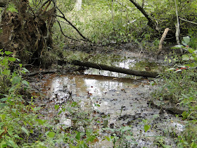
I reached a swamp formed by the Western Branch of the Corrotoman River, and poked around there a bit, enjoying the interesting plants, flowers, and insects.
Here was an unexpected sight in the swamp - Old Glory flying from a tree!
Later on the hike, a totally different tree, I pondered if maybe there is a screech owl that makes this hole its cozy home. I have screech owls on the brain since being serenaded a week ago at Goose Creek State Park in North Carolina.
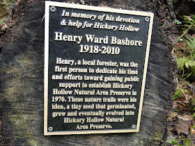
I enjoyed reading about this man and his good works. It is nice to remember people who made a difference after they are gone.
I'd like to get back here and explore this area further. Other than hearing some birds - Carolina chickadee, blue jay, and red-bellied woodpecker - and seeing a couple of salamanders and a frog, I didn't see any wildlife to speak of. But I enjoyed exploring a new area. I didn't see another soul while hiking here for a couple of hours.


