Showing posts with label wilderness. Show all posts

Friday, October 26, 2018

Visiting the Priest

I resolved to go hiking Wednesday, and I felt that it was time to visit The Priest.  Not a priest, The Priest.  Here is what Hiking Upward has to say about this hike to The Priest from the north: "Many folks express great fear when thinking about hiking The Priest from VA 56. Although The Priest isn’t found on the list of the 50 highest mountains in Virginia, it rises straight up from the valley floor and forms part of an impressive skyline when driving in from the Tye River Valley. This hike involves a 3000 foot elevation gain (higher than any trail in West Virginia), however the trail is seldom steep along the way, and can be better characterized as “unrelenting” rather than difficult.  Once the trail starts climbing, it maintains a remarkably constant 13% grade for 3.6 miles before steepening slightly for the last 0.3 mile to the summit."

Actually, the elevation gain is 3,117 feet - just saying!  I had heard tales about this hike for a long time, and was in the camp that kind of feared it.  But then again, I knew that it could not be as hard as the White Mountains, where I had a number of really long days over steeper trails with large boulders thrown in. I'd actually been to The Priest before, on my first trip where I resumed backpacking after a long gap, but I'd approached the mountain from the south where it is not as much of a climb.  The two things that I remembered most from that hike was the very cold night on top of the mountain, and the simply amazing stars.

After a drive of about 115 miles from my house, I got to the Appalachian Trail parking area at the Tye River Gap, and immediately hiked into The Priest Wilderness Area.


Here is the route, starting and ending at the red circle.  The red arrow points to my turn around point, and the blue arrow shows the location of the shelter, which I did not hike to this trip.  My Garmin inReach tracked the hike at 9.3 miles, but Hiking Upward has it as 8.6 miles.

The elevation profile from Hiking Upward matches the description - steady uphill, and steady downhill once one turns around.  The summit is flat, and I walked to where I camped 8 years ago, which has great views.  The approach to the mountain is much steeper for the last half mile of the hike up.

Again from Hiking Upward, here is a three-D view of the hike.  Up, up, and away!  It is a very good test of lower body fitness.  My heartbeat was a steady 130-145 all the way up, and about 110 coming down.

I really liked this hike.  It was a beautiful, cool October day, and unlike Pennsylvania a couple of weeks ago, the colors were starting to change.  It was a steady uphill climb, but the lower part of the hike didn't have a lot of rocks or roots to trip over, and I made steady progress.

Lovely Cripple Creek had a kind of water slide, which I was not tempted to try.  This is the last source of water on this hike. I carried two liters, which was more than enough on this cool day.

More fall color underway.

By this point, I had gained nearly 2,000 feet in elevation and was rewarded with a great view.  It had taken me about 2 hours and 15 minutes to reach this point, and I had come about 2.6 miles, including short breaks for photos.

This tree was so stark against the sky.  It was once a living thing.

It took me a good while to go the last mile or so, as the terrain got steeper.  I encountered a man hiking north along the AT with a big backpack.  He was midway through a week long hike.  He said "I am sure that I'm enjoying this more than you are," referring to the steep climb that I was in the middle of.  Eventually, I did reach the summit, which has a nice flat part for a while.  If this were West Virginia, a summit at 4,000+ feet would be covered in spruce and fir, but not here.

I walked until I reached the area where Hawkeye and I had camped that cold, starry night in 2010, then walked out onto the rocks with the great views, and ate lunch.  A couple of dark-eyed juncos came within five feet of me as I munched on my sandwich, but I could not get their photo.  Other than a gray squirrel, they were the only animals that I saw on the hike.  It was cold and windy on the summit of The Priest.


The hike down looked exactly like the hike up.  Once I carefully got past the steepest section, I made really good time.  It took me about two hours and 15 minutes to get back to the car as I steadily lost elevation.  My car was at about 950 feet elevation, the summit is about 4,062 feet.

I was glad to visit my old friend, The Priest, this time from a more challenging direction.  Although this was not an easy hike, I think that I am in better shape than I realized, because it never felt too hard, and I never felt like I needed a priest for last rites.  Was it a religious experience seeing The Priest?  Well, I never feel closer to God as when I am out in nature, so, yes it was!  I was in God's Cathedral!  So, do not fear The Priest, as many hikers apparently do.  Go out, climb, and enjoy the day and the experience!

As a post script, I heard a few birds that I did not see: Carolina or black-capped chickadees (probably the latter up this high), pileated woodpecker, downy woodpecker, and red-breasted nuthatch.

Saturday, September 3, 2016

Checking Out the Ramsey Draft Wilderness

I've heard a lot about the Ramsey's Draft Wilderness just west of Staunton, Virginia, and since  we broke camp early Wednesday a week ago in West Virginia so my brother Chris could get back to Missouri, I drove right by the trailhead on the way home plenty of early enough to try a short hike and check it out.  I could quickly see that this place is not for sissies.

Wilderness areas don't get the same careful care that parks do because they are, well, wilderness.  There are no trail blazes to show one the way, and there is no trail maintenance.  If a big tree falls across the trail, deal with it.  If the trail becomes choked with vegetation, press on.  It the trail seems to disappear, figure it out, or turn around.

I knew I didn't want to try a long difficult hike.  I just wanted to do more of a scouting trip to see what it is like, and I only went about a mile up the trail along Ramsey's Draft.  Then I returned and hiked a half mile or so up another trail that started out being out of the Wilderness area.  I've read accounts that the conditions for hiking here can be confusing and very difficult, and I believe it.

Here is a track of my hike.  The red arrow indicates the mile hike up along the creek, and the blue arrow points to the closing hike up the side trail.  If I kept going along either one, I could have reached Hiner Spring, which is supposed to be a beautiful area to camp in.  But you're talking 9 to 11 miles of difficult going to get there.  Maybe I will come back and do a longer hike or a backpacking trip here, but I can see that I will have to be fully prepared for tough going.


Here are some pictures from my hike on August 24, starting with a view of Ramsey's Draft at the start of the hike.

I thought that the yellow beetle, which I need to try to identify, on the yellow flower was really

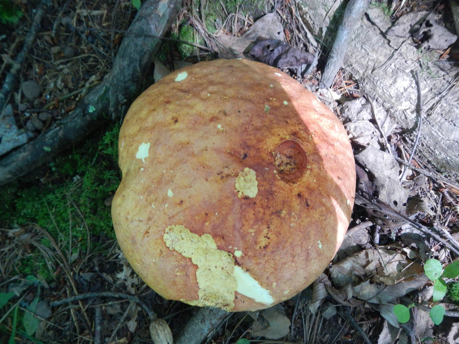
This mushroom was as large as a small dinner plate!  I wonder if it is edible, or if it would destroy your liver cells, leading to an awful death?

Hemlock is supposed to be common up here.  I know that it has been decimated in many parts of the East by the woolly adelgid, a tiny bug that came from East Asia.  Many of the huge hemlocks in Shenandoah, for example, are ghosts now.

I bet that woodpeckers love this tree!  I heard a pileated woodpecker but didn't see one.  Nor, other than that beetle and a few butterflies, did I see any wildlife.

Sometimes the trail was distinct, and other times I was not sure if the trail had crossed the stream and I was on a game trail.  Without trail marking, it is difficult to follow.  Imagine being an Indian or explorer 250 years ago here when it was true wilderness!

Sometimes the trail - if this even is the trail - was totally choked with vegetation, including thistles.  After a mile, I reached a point where I felt like the real trail had to have crossed Ramsey's Draft, and I had no idea where, so I turned back.

This is the Bridge Hollow Trail, out of the wilderness area and marked with yellow blazes (and maybe yellow mushrooms - see below).  It climbs steadily for two miles and is very easy to follow.  At that point, it connects to the Bald Ridge Trail, which goes back in the wilderness area up to Hiner Spring.  Part of me wants to try this on a 2-3 trek. Part of me says it would be tough going.


Well, my hike was short but sweet, and I at least got to check out Ramsey's Draft Wilderness a bit.  When my ankle and foot are close to 100%, I think I'd like to come back.  But you don't want to tackle this place if you are not at your game!