Monday, June 28, 2010

Carter and Madcap Falls

After my morning hike first in snow and then along a road to return to the Narada Falls parking area, I was ready for a snow free hike, so I headed back towards Longmire and lower elevations. Near the Cougar Rock Campground was the trailhead to Carter and Madcap Falls on the Paradise River. This hike was very easy to follow and was mostly along the Wonderland Trail, and gained about 650 feet during its mile and a half one way ascent.

From the trailhead of the hike, I dropped a short way down to the stony wide banks of the Nisqually River that were created from flood stage. The river itself was crossed by walking over a fairly new split log bridge, the last one having been swept away in a flood.
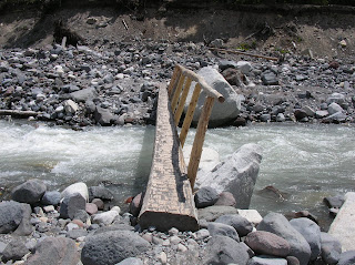
The cold glacier river swept just under the log and, with its speed, was mesmerizing during the crossing. Majestic Mount Rainier was on full display upriver, the melt-water of the Nisqually Glacier forming the speedy river.
Upon crossing the river I climbed into the woods, and joined the Wonderland Trail, which climbed steadily but not steeply through the pretty woods along the Paradise River.
The hike itself was fairly uneventful as far as wildlife, although there were some pretty big trees along the way,
as well as some pretty flowers, like this trilliam.
The scenery past the river was beautiful as I hiked,
and after about 1.3 miles I came to the first big waterfall, Carter Falls. There were a number of hikers out there enjoying the woods and the falls.
From there, it was supposed to be 0.3 miles to Madcap Falls. I could hear it but not see it, and finally turned around after going about a half mile. On the walk back to Carter, I suddenly came on a large waterfall right near the trail – Madcap Falls! I snapped a photo, and realized that it was only 0.1 from Carter Falls. I had walked right by it, expecting it to be further along and thus not alert for it. Although as loud and close as it was, I must have been sleepwalking.I retraced my steps to return to the car, then decided to visit the Jackson Visitor Center, and after that, to drive towards the east and see some new areas.

Narada Falls to Reflection Lake

On June 28, after seeing the great views of Rainier, I left for my first hike of the day, starting at Narada Falls. My goal was to hike the Wonderland Trail to Reflection Lake. At that point, if the snow seemed OK, I was thinking of hiking up to Pinnacle Saddle. This hike would be an out and back: 1.5 miles and 500 feet to Reflection Lake, another 1.75 miles and 1,100 feet to Pinnacle Saddle, then a repeat back to the start. Once again, deep snow interfered with my plans. But although the hike didn't go as planned, I still enjoyed amazing scenery - and I met three very interesting ladies.

The hike started at a popular spot - the Narada Falls overlook. The upper falls on the Paradise River thundered over a sheer cliff, dropping 168 feet nearly straight down:
A short but steep hike led to an overlook of the upper falls, but the spray was so intense that I walked quickly past it and took this photo at a less advantageous spot:
From here, there was a shorter (20 foot) lower falls, then I started hiking on the Wonderland Trail, heading for Reflection Lake.

As I gained elevation, I ran into more and more deep snow patches that had to be crossed. I kept going, but after a mile or so, the snow was just continuous, and I could not figure out where the trail to Reflection Lake went. I stumbled around several different directions trying to pick it up. There were deep ravines around with streams running through them, and everywhere I looked, there was snow.

I knew that the road was just a couple hundred feet to my left, so ultimately I decided to give up on the trail and hike to the lake along the road. I headed left, scramble up a steep, snowy slope, and slid into the road. The views were amazing, including this view of The Pinnacle.
When I got the lake, I found it totally frozen over. Mount Rainier, looming behind it, was magnicent.

No one else had walked there, but there were a number of people driving in for the views, and I asked them to take a photo of me with the volcano as backdrop.
I found the trailhead to Pinnacle Saddle, decided it would be folly to try to hike up there in this much snow, and started walking back along the road.
I knew from my maps that there was a trail cutoff from the road that would get me back to the falls parking lot that would keep my walk to maybe 3.5 miles. So I planned on taking that. Along the way, there was more stunning scenery.

I ran into three ladies hiking down a side road. We stopped to chat. They hike here every Monday together, but one of them had hip replacement surgery 8 months ago and so they were taking it easy. The shortest of them, at least mid-70's, is the oldest woman (or person, I forget) to climb to Rainier's summit and down all in the same day - a 19 hour trip. The day before, she hiked up to Camp Muir - a climb of 5 miles each way with an elevation gain of 4,600 feet! "You should rent ski poles and do it!" she said. Not likely, thought I. I found their spirit and friendship inspirational.
I reached the cutoff trail, near this point. It was covered with deep packed snow, and very steep. I decided to keep walking another 1.5 miles or so along the winding road. It seemed safer.
Along the way, I saw other waterfalls: and a black-tailed mule deer.
I ate a snack at the car, and got out my guidebook and map to plan the next hike of the day. One thing I decided - it would be below snow level.

The View From Paradise

After getting back to the car from my Rampart Ridge hike, with very tired legs, it was time to head for my domicile for the next two nights - Paradise Lodge. The Paradise area was named by an early settler who was viewing the wildflower meadows with Mt. Rainier in the background. She reputedly said "This must be what Paradise looks like." At about 5,400 feet elevation, Paradise looked like winter in Maine to me on this June 27. Mount Rainier, looming 9,000 feet higher than this area, was mostly in clouds but I could see some of the massive glaciers on its flanks.

The first thing I did when arriving at 7:30PM was to ask how late the restaurant served dinner, which was last seating at 8PM. I checked in to my small room (with shared bath down the hall), washed up a bit, put on clean clothing, and went to the dining room. First order of business: a Moose Drool Brown Ale, brewed in Missoula, Montana! Then, dinner! After eating, I sat outside in the chill air, thinking about 100 degrees back in Virginia, and watched a heavy fog roll in. "That's the last I see of Mount Rainier," I thought. For the second time that day, how wrong I was. I went back inside and attended an hour long presentation on the geology of the area, conducted by a National Park ranger.

The next morning, I looked out my little window and was shocked to see brilliant blue skies! I dressed quickly, grabbed my camera, and went outside. Mount Rainier, all 14,400+ feet of it, was exposed from its blanket of clouds, and the jagged sawteeth of the Tatoosh Range, formed something like a million years ago when a lava flow encountered a glacier, were prominant to the south. Before getting hot tea - I am a hot tea fiend - and a cinnamon bun for breakfast, and starting on my first hike of the day, I snapped a bunch of photos from the road of the magnificent scenery. The last two photos shown here were taken from the road on the way to my first hike.

Here is a pararamic view of the Tatoosh Range from the road.

Closeup of part of the Tatoosh Range.

Mount Rainier, mostly out of the clouds

Avalanche chutes on one of the Tatoosh Range peaks

Mount Rainier framed by evergreens

Sunday, June 27, 2010

Rampart Ridge Circuit

June 27. I reached the Longmire visitor area of Mt. Rainier National Park about 4PM, and debated about doing another hike. I decided I had time for a 5 mile circuit hike up Rampart Ridge. I made sure I had warm clothing and rain gear in my pack and started hiking. This turned out to be one of my favorite hikes of the whole three days, with really nice forest hiking and some great views. It involved gaining over 1,300 feet elevation, and my legs were still tired from the half marathon the other day. But you only live once, and I was here to hike. I decided I had time to do this hike and still get to the Paradise Lodge in time to clean up and hopefully get some supper.

Here is a 3-D topo map view of my track, captured by my DeLorme PN GPS. I hiked it clockwise. The first part of the hike went along a nature trail called the Trail of the Shadows. But I quickly left that and headed uphill with a long continuous pull with many switchbacks, gaining 1,300 feet in less than two miles. Then the trail meandered easily along the ridge with great views before coming back into the dense forest and a steep downhill two mile section back to Longmire.
The only wildlife I saw was a Steller's jay, and tons of mosquitos when I stopped for about 20 minutes to send a SPOT check-in. I was tired and foot-sore when I got back to the Longmire, having now walked, run, and hiked about 35 miles since arriving in Seattle 78 hours ago. Plus all of the time on my feet caused my Morton's neuroma to act up big time, and every step with my left foot on the hike down was very painful.

Here are photos from the hike. This first is a view of Longmire Meadows near the start of the hike.
Part of the scenic forest portion along the Trail of the Shadows.
View looking nearly 1,300 feet down to the starting point of my hike at Longmire.
Views of the Tatoosh Range
A family hiking to this point snapped a photo of me. They were the last hikers I saw on this hike.
After the steady climbing to get here, hiking along the ridge was a breeze.
Flowers with Team in Training colors
Great views of snow covered peaks from Rampart Ridge

Awesome Mount Rainier was partially in and partially out of the clouds
This Steller's jay was not only beautiful, but he seemed to want to guide me. He hung around for a good ten minutes, hoping for a handout. But it is a bad idea to feed wildlife. It was at this point of my hike where I did feed some mosquitos, without wanting to.

This was one of the only views from the dense forest on the way down. I took out my field glasses and surveyed the white patches to see if I could see any mountain goats, but, alas, 'twas all snow.

Twin Firs Loop

After my disappointing aborted hike on the way up Mt. Beljica, I drove the steep and torturous gravel road back down the steep grades the afternoon of June 27. The five or so miles took nearly a half hour as I concentrated completely on the driving so as to not trash my rental car. At one point there were twin boulders on each side of the road with inches to spare on either side of the car. I am not even sure how a truck or SUV could get through there. But one couple was camped out along a remote mountain stream with their pickup.

I got back on to the main road and headed east. The Longmire entrance was just a few miles away, and I headed into the park. My first hike in the park was going to be the short and easy Twin Firs loop, a half mile interpretive nature trail through a forest of large trees.

The interesting thing about this pretty hike was not only the living forest, but the giant trees that were now slowly decaying logs, putting their nutrients back into the soil (and their carbon back into the atmosphere). The trees were beautiful, and it was like walking through a magnificent cathedral designed and built by God. As I walked along, there was an interesting mix of the big dead logs, huge living trees, and the young growth that will become the giant trees of the future, if Mount Rainier doesn’t erupt in their lifetime.

Here are a few photos from the Twin Firs hike. In this first, I set my camera for a self photo, and posed against a large downed tree.
This picture gives a sense of the easy trail, and also shows the various components I wrote about: dead trees, large living trees, and the future generations.
I laid my Tilly hat along this tree's base to give you a sense of scale. My hat is just over a foot in diameter.

Partway to Mount Beljica

June 27 - The first hike I planned at Mount Rainier was actually outside the park, a steep hike up Mount Beljica. It would be a two miles each way (four miles round trip) as an out and back. I studied the route on my topo map and in my guidebook, and wondered it I would run into snow. I finally decided that there was no way there would still be snow up there this late in June, and a lot of the trail seemed to be south facing. I've been wrong before, and could not have been more wrong this time.

I should have turned back on the drive up to the hike along very steep, very narrow, very rutted and potholed gravel roads. I was driving a small rental sedan with low clearance, and went very slowly. When I finally got there and an SUV pulled in next to me, the driver said "I didn't think if was possible to get such a low clearance vehicle up here. You must be a very skilled driver." I think that was a nice way of him saying "you must be out of your blooming mind!"

But I was there, the trail conditions looked great, and I started hiking. Two miles ahead, and 1,100 feet up lay the summit of Mount Beljica. If I were lucky, I would have great views of Mount Rainier at the top. The trail climbed steadily through the woods.

I came on a pretty trillium...

And a while after that, something not as pretty but very interesting: mountain lion scat!


I came on a really pretty view at a switchback, back to the west. It was a little reward for all the climbing, and so far, there was no snow to be seen. I was feeling hopeful about doing this hike. I bet I was right about the south facing slopes clearing off.

But when I caught up and passed a party ahead, I began to get nervous. They were crossing a very steep and deep patch of snow. "Well," thought I, "I can get across this OK."

I continued hiking up the path, running into more and more snow patches to cross. Then, as if a switch had been thrown, I walked into a winter wonderland. Back in Ole Virginny, it was 100 degrees F. and here I was next to a partially frozen lake. My destination, Mount Beljica, loomed high above the lake in the distance:

The woods all around were covered in deep snow. It looked like Maine in February, and the evergreen trees were so pretty against the snow.

I trudged through the snow for about 5 minutes, trying to figure out which way the trail went. It wasn't clear to me. I knew that I still had to climb 600 feet, part of it a scramble up and over a very rough and steep mountain according to the guidebook. The snow would only likely get deeper as I climbed. I was by myself, and totally dependent on myself alone in a very rugged near-wilderness. I had run a half marathon just the day before, at a personal best pace, and my legs were feeling the effects of that. After thinking about it, common sense - not always a trait I am accused of having - won out over the desire to press on. I reluctantly decided to head back and find another hike.

As I mulled this over, the party that I passed caught up to me. I asked them about a route to the top, and they told me that they didn't know, and were turning back as well. They had not expected the deep snow either. They kindly snapped a shot of me with Lake Christine and Mount Beljica in the background, then I turned around and headed back the way that I came.

Here is a topo map with my out and back route, represented in 3-D, as captured by my PN series DeLorme GPS and mapped by DeLorme Topo USA. My route was about 1.6 miles and I climbed just about 500 feet. The blue pushpin represents the approximate location of Lake Christine as I mapped it back home before going to Washington. I think I was pretty close.