Thursday, March 31, 2011

Our National Symbol

I have a 10K race coming up in two days, and have had all kinds of problems training for it – the latest being another bad cold, a couple of migraines, and a very sore knee. So I did not run this past weekend, but I did try a hard workout on the elliptical machine to see how my knee felt. The answer was – no worse. So Monday and Tuesday being nice days - before an accurately forecasted rainy period - I decided to walk at lunch so I could at least get a little exercise that would help me with my upcoming race.


I managed to get in about 3.25 miles Monday and 3.75 miles Tuesday, both on walks to Belle Isle, the site of a terrible Civil War prison camp 150 years ago, but now a tranquil and pretty place in the middle of a big city. During both hikes, I spotted a mature bald eagle in a tree up river, and on Monday’s trek, there were two large ospreys in a tree down river. Just a half mile or so down river is the site of a large great blue heron rookery.


There is something really cool about being in a large city and seeing a bald eagle - that something so wild and so symbolic of both our country and of wilderness can live so near to so many people. As much as I enjoyed my walks, I enjoyed even more thinking about this bird, and what it represents.

Sunday, March 20, 2011

North Anna River Battlefield

Sometimes things don't work out as we plan, and yesterday was a good example. I decided to take a March Madness break for a few hours and go for a hike, my first in boots since the foot surgery 8 weeks ago. I chose the Cumberland Marsh Natural Area, a place that I had never been. It has what sounds like a nice 4.5 mile hike with the possibility of seeing marsh birds and other wildlife. So off I went!

As I reached the tiny, and empty, parking lot 50 minutes later, I pondered why no one else would be here on such a nice spring day. I got out of my car and approached the informational board, on which was posted a large sign saying that the area was closed because of unstable dams. Damn indeed! My car gets about 52 mpg on a trip like this, but even so, I had just wasted nearly a gallon of gasoline! I turned around and headed back, deciding for a shorter hike at the North Anna River Battlefield Park instead. It would be about 15 miles out of the way to the north on the way back.

The North Anna River site marks a vicious battle fought near 150 years ago on May 23-26, 1864 as Grant kept trying to get around Lee's army on the way to Richmond. It happened shortly after the much bloodier battle at Spottsylvania Courthouse and just before the huge and very bloody battle at Cold Harbor. Because of a strong Confederate defensive position, the river, and Union mistakes - including an ill-advised attack by a stone-cold drunk general - the US Army became divided into three parts. Lee was ill, and his generals could not execute his battle plan without him. Thus, his battered army could not take advantage of a golden opportunity. Otherwise, this could have been a very bloody battle, and a large part of Grant's army might have been destroyed or captured. I would guess that for the 5,000 men who were killed, wounded, or captured, it was plenty bloody and miserable enough.

It never fails to strike me how peaceful these battlefields are today, in sharp contrast to the violence, pain, and misery that once occurred on these bucolic grounds. The photograph of the poem at the end of this post sums up that sentiment very well.
The 2.5 miles of out and back walking are mostly level and easy. What are woods today would have been mostly open country at the time of the Civil War:
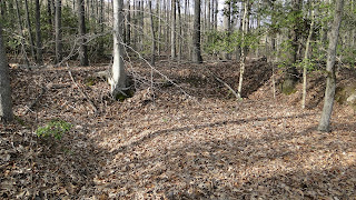
The Confederate Army dug extensive defensive trenches here. Nearly 150 years later, many of them are still in evidence. They built a strong defensive position with the North Anna River on one side and a trench line like an inverted "V" - such as the point of a spear.
Even though the trail was flat, the surrounding terrain is often steep. Here, you can get a hint of the North Anna River right at the end of the defensive works and several hundred feet below. It must have been hellish to have to fight a battle on these grounds.
At the entrance to the park is a memorial plaque with a very apt poem of reconcilliation it. We are one country now, not many.

Sunday, February 27, 2011

Bay Walk, Beach Walk, Brisk Walk

Today, I took the longest continuous walk since my foot surgery just over a month ago. I walked 4.5 miles in Back Bay National Wildlife Refuge, most of it on the beach, although the first mile of the hike was along the bay and marsh.

I slept poorly last night and was awake by 5:30. I could easily have made this another dawn beach walk, but instead, I got up for good about 6:10, and relaxed with a mug of hot tea while listening to a Mozart piano concerto (#12, so lyrical and serene!), and read about great hikes in my latest Backpacker Magazine. Around 7AM, I drove to the refuge and started walking about 30 minutes after sunrise. The tide was ebbing, as shown by this screen shot from my GPS:
Here is my route, mapped onto my DeLorme Topo USA software from my GPS. I hiked south through the marsh, cut through the dunes to the beach, hike south on the beach about a mile and a half, and then reversed course to eventually cut back through the dunes north of my original beach access point:

There is something so tranquil about a early morning walk on the beach. It gave me some time to reflect on things in my life, think about the recent passing of my friend, Judy, and think about my sister and her illness. Along the way, I tried to be at peace with how things are right now. The wind was brisk and raw at times, but it felt good to be out walking and communing with nature. Here are some photos from my walk.
Cattails along the marsh:
Tundra swans, heading north towards the Yukon:
And resting in the marsh:
Boardwalk access to the beach protects the dunes:
This driftwood appears to guard the beach:
The ocean is so tranquil this time of day:
It is like this all the way to the North Carolina border about 9 miles down the beach:
Pelicans are such a cool bird:
This claw is all that remains of a blue crab, which survived against inconceivable odds to become an adult. Probably, some of his molecules live on in the muscle tissue of a gull:
This gull has managed to find breakfast:
Dunes protect the marsh. The dune zone here is about a quarter mile wide:
Swans fly in "V" formation over the ocean, heading north:

Wednesday, February 23, 2011

Stomping Breast Cancer With Hiking Boots

My friend Chris, AKA “Hawkeye,” steps off in about a month to head north on the Appalachian Trail. He plans on hiking about half of it, ending at Harpers Ferry, West Virginia, or just over 1,000 miles. And he has decided to make the hike about something bigger than just a long walk in the woods. He is going to raise money for the Susan G. Komen For a Cure organization. Chris’s wife is a recent breast cancer survivor.

Breast cancer is a horrible disease. I was thinking today of all the people I personally know who have had to face it. My sister, Ann, who is fighting stage 4 right now. My sister-in-law Christine, who is a 22 year survivor. My friends Janice, Mary Beth, and Bev. My former co-workers Lisa and Linda (who died from it several years ago).

I hope someday we can stomp this disease into the ground, and all other cancers. That is why I race for a cure, and it is one reason Chris is doing this long hike. If you are interested in following Hawkeye’s preparation and progress, you can do so here.

And if you would like to donate to the fine Komen organization in support of Chris’s hike, you can do so here. Even a penny a mile, just a $10 donation, will add up in this desperate fight to kick breast cancer – with hiking boots, in this case - to the curb!

Monday, February 21, 2011

The Last Sunset

I saw an amazing sunset at the end of my New Year’s Eve hike in the Back Bay Wildlife Refuge. The next day, I learned of a poetry form new to me, the monotetra. It has the following rules:

Each stanza has four lines.
Each line has exactly eight syllables.
The end of the first line in a stanza rhymes with the end of the other three lines in that stanza.
The final line of each stanza repeats the same four syllables.

So, inspired by the beautiful sunset that evening, I thought I would try writing a monotetra about it a day or two later, and here is my effort. I decided tonight to finally put this out on my blog.

"The Last Sunset"

I stand and watch the setting sun
On New Year’s Eve; day’s course has run.
Feels like this year had just begun,
Yet now it’s done. Yet now it’s done!

Vivid hues paint darkening skies;
Swans fill the air with their wild cries;
One beats its wings and starts to rise.
How high it flies! How high it flies!

The sky, in hues of orange and rose,
Tints faint with blush last weekend’s snows
Mother Nature so proudly shows
Her new year’s clothes - her New Year’s clothes.

Across the marsh, last light subsides;
‘Neath cloak of darkness, the sun hides;
Towards history, the old year glides;
New Year presides! New Year presides!

I know one day my sun will set
Although that’s easy to forget.
When that day comes, will I regret
Things not done yet; things not done yet?

Art Ritter
January 2, 2011

Tuesday, February 15, 2011

Lunch Time Walk to Great Blue Heron Colony

2011 has not gotten off to a great start for hiking, or too much else, actually. First, there was the death of our dear friend, Judy, at the start of the year - just four weeks after being diagnosed with multiple myeloma. Two days after her memorial service, I headed to upstate New York to visit my sister Ann, ill with stage four breast cancer. Five days after I got back home, I had foot surgery, which has pretty much sidelined me for three weeks.

I took the bandage off yesterday for good, and decided I needed a little lunch time hike today. I went to the great blue heron colony in the James River, right in downtown Richmond. This is an interesting urban hike, as documented in more detail in my blog here almost a year ago. My walk today was 2.25 miles, and I had no trouble at all, despite my foot surgery of 3 weeks ago. It felt great to take a walk on a nice day and enjoy some views of the river and wildlife. My route, as tracked by my DeLorme PN-60 GPS, is shown on the map below. I walked in a clockwise direction, and the three little images show where I took my pictures.

Here are some herons on their nests, high in the trees on an island in the river:

A view of the island from where I stood, with many nests in sight:

Nice painting on a bridge support, with a formal sign on the other side of the support:

Rapids further upriver:
View of Tredegar Iron Works Civil War Visitor Center:

Saturday, February 12, 2011

A Short Walk

I am still limping but can almost walk normally now, as long as my foot is wrapped and stuffed in an open shoe, like my Croc. I can maybe walk at a 20 minutes per mile pace, which is slow for me, but at least people are not passing me as much along the street as I go to and from the car at work.

Yesterday was a nice day, and I am sick of being a coach potato and sedentary person. So I decided to trade a little foot pain for some exercise and fresh air. It was not exactly a hike, but I walked up to the State Capital Grounds and made a loop around the Capital. Virginia has a really beautiful Capital, designed by none other than Thomas Jefferson.

I stopped at one of the best monuments I have ever seen, the one dedicated a couple of years ago to the Civil Rights movement, right on the grounds of the Capital of the Old Confederacy. It is a beautiful and moving monument, and I am always inspired when I see it. It is the only monument on the grounds that depicts a woman, a minority, and a child. I paused for a few minutes and reflected on that part of our country’s history.

I continued down the brick walkways and back to the street. I decided to go pay respects to our former State Supreme Court Chief Justice, Leroy Hassell, who’s body was lying in state in the capital building. He died from lymphoma a few days ago at only age 55. I don’t know him, of course, but as a cancer survivor, I feel a connection. He was the state’s first black Supreme Court justice, and also the first black chief justice. So I walked up through the Capital Building to the rotunda, where his flag-draped coffin stood next to the remarkable Houdon statue of George Washington.

From there, I retraced my steps to go back outside, and thence back to work. It felt good to move around a bit. I can’t wait to be able to walk normally again, then ultimately try a real hike and some running! But that is all still some weeks away.

Tuesday, January 25, 2011

Could I Be the next Backpacker Magazine Field Scout?

So, Backpacker Magazine has a contest to become their field scout for an issue. The deal, for the winning entry, is that Backpacker pays for a backpacking trip in the “Lower 48” for the winner and a companion. The trip cannot exceed seven nights, and part of the assignment is to present the trip to Backpacker readers. To enter, one could submit an essay – not to exceed 300 words – or a link to a personalized video or web page. Three hundred words is not a lot to show why I’m the best hiker for the job, and how I could bring the adventure to life for their readers, but here is my entry: 293 words long. Wish me luck!

First, my girlfriend dumped me like a load of gravel, prompting me to decide that two weeks in the Rockies would cure my funk. Then, my car broke up with me in Ohio, so I thumbed a ride to northern Minnesota, and caught the ferry to Isle Royale. A 20 year-old greenhorn, I hoisted a heavy pack that was missing several of the 10 essentials, but was crammed with the 50 non-essentials. I staggered along like an abused pack mule, generously donated blood to hordes of mosquitoes during tent-less nights, and fell into a river vainly attempting to photograph a moose. And I had such a good time that I want to go back!

From Rock Harbor, I’ll plan a circuit route over the Greenstone Ridge, Minong Ridge, and Rock Harbor Trails. This time, I’ll carry only what I‘ll need to safely hike a seven night trip, and to record it for Backpacker. The latter will include my DeLorme PN-60 GPS to record the track and waypoints. My digital camera, constant companion on my treks, will come along to capture images, hopefully to include a moose – sans dunking! Back home, my Topo USA software will map the track and synch my photos geographically. And on the trail, I’ll periodically send custom messages using my SPOT synched up with the PN-60. I’ll record field notes in a standard notebook, though.

I may not be your guy to lead a three-week trip through the Yukon, but I’ve done plenty of hiking and have enough backpacking experience to do the trails of Isle Royale again. And I like to share my hikes, as evidenced by my blog: http://o2bhiking.blogspot.com/. Appoint me as your field scout, and I will take your readers along to this magical island park!

Sunday, January 23, 2011

My Last Walk for a While

I didn’t exactly do a hike today, but it was close enough. And with foot surgery tomorrow, that will hopefully take care of this neuroma once and for all, it will be the last walking, hiking, or running for me for a while. I am not sure how long it will be before I can walk normally again: normally for me being at least five or six miles at a pace of at least 14 to 15 minutes per mile. I am guessing at least a couple of months, and maybe longer, will go by before I can walk at that level again. Hopefully the surgeon can give me some clues about it.

On this cold winter weekend, I knew I wanted to go for a long walk at the least, since I won’t be physically able to do it for a while. I had too much to take care of around the house to go for a real hike anywhere – plus I have a cold. So five miles walking laps around Echo Lake seemed like a good way to go. I’ve not been running much or talking walks longer than a few miles very often in the last couple of months, but I was still able to walk the five miles (seven laps on the wooded trail that goes around the lake) in 64 minutes, which translates to 12.8 minutes per mile average walking pace. After five laps, my ears were so cold that I grabbed my hat out of the car for the last two laps.

On the mostly frozen lake, I saw groups of ducks looking for open water. As I moved through the woods, I saw little groups of sparrows, but that was about it for wildlife. I didn’t take pictures, as I have them from before on the other post about Echo Lake.

I was thinking of taking another long walk or even do some running in the morning, but I will get too thirsty. I can’t eat or drink before my surgery. So today will do it for a while. It will feel strange to be so sedentary for a few weeks. Hopefully the thought of hiking and walking in the spring weather will sustain me during that time! And I’ll be tracking recovery progress on my Racing for a Cure blog.

Thursday, January 6, 2011

A Splash of Color on This Winter Day

Back in November, I took my final fall color hike of 2010, but could not post the pictures because I couldn't find my camera's USB cable. Well, that hasn't changed, but I bought an SD card reader, so here are some photos from that hike.
My hike did about a seven mile loop along the James River, and for much of the time, you would not know that you were near a big city. Here is the start of the hike, along the North Side Trail.
The trail at first was adjacent to Maymont, and this burst of fall color appeared quickly:
And this pretty scene at Maymont's Japanese Gardens begged for a photo:
At this point, the trail climbed steeply over some switchbacks and headed through a residential neighborhood for about a half mile. This tree was at one of the switchbacks:
Back in the woods, this little maple was pleasant to the eyes:
The trail passed by two cemetaries. This one is the beautiful Hollywood Cemetary, sometimes called "The Arlington of the Confederacy" and site of at least one hilly Team in Training run each season:
As I neared the Robert E. Lee Bridge to cross over to Belle Isle, I had a view of Tredegar Iron Works with Richmond just beyond:
The Hollywood Rapids are always inspirational to see. Belle Isle is my favorite spot in the city, and is also my favorite Team in Training workout. We do that run at least once a season as well:
After crossing the other half of the river from Belle Isle, I headed north along the Buttermilk Spring Trail, so named because dairymen of old would put their jugs of milk in the spring to keep it cool:
This beech forest could have been in New England:
As could this rocky ledge, all just a couple of miles from a large city center, and closer still to neighborhoods:
I crossed back over the James over the Boulevard Bridge just at sunset. If I had $25 for every time I have run or walked over this bridge during Team in Training runs, I could take a pretty nice trip!