Thursday, June 5, 2014

Arthur's Seat, Edinburgh, Scotland

Well, when I was in Edinburgh on May 23rd, you know that I would have to hike up to Arthur's Seat, a volcanic plug with spectacular views.  So after touring Edinburgh Castle and having afternoon high tea, and with decent weather for good views from the top, my brother-in-law Tom and I headed down the Royal Mile to gain the trailhead.  If it had been raining, I probably would not have done this, because the reward from the top of the 830 foot peak are great views.  But still, how often do you get the chance to hike up a point sharing your name?

Using the DeLorme InReach SE that my friend Chip loaned me for this trip, I was able to map my approximate track (in light blue).  See the arrow to the left?  It points to Edinburgh Castle, which is amazing.  From there, Tom and I marched a nice straight line, in light blue, down the "Royal Mile" before reaching the jump-off point to the trails up Arthur's Seat.  The arrow on the right points to Holyrood Palace, the official residence of the British monarch in Scotland.  It is often open for tours, but not on that day.  Apparently, some royalty or other was in residence that day, as the gates were shut and security was very tight.  Our route up Arthur's Seat was more or less in a clockwise direction from there.

Silly me - at the start of our hike, I thought that this was the top.  There was a line of people heading up that trail, so we picked the "road less traveled," the trail to the left.  No matter which way we went, there were lots of people.  This is a place for great views but not for solitude!


After walking for a while up the path, we found that this is the top.  It took about 40 minutes of steady uphill walking to reach the top, including a brief stop at a ruined chapel.

This is all that is left of the Saint Anthony's Chapel.  In 1426, the Pope gave money for the repair of this chapel.  Looks like it might be time again for some repairs, eh?

Near the ruins of the chapel, Arthur's Seat still looms hundreds of feet above us.  The yellow flowering shrub is gorse, I believe.


I think this bird is a hooded crow.  We do not have them in the "States."

Here is a panoramic view looking back towards the lower hills and the bay.  We are starting to get the first of some great views.

We hiked up some more, and at this point, we are getting closer to the top.

Up, up, up....

Before we know it, after a final push over rocks and steep trails, we were at the somewhat crowded top.  Great views of Edinburgh presented themselves as a reward for the hike up.

This is a panorama from the top.  Fabulous views!

Art(hur) at the top of Arthur's Seat on a very windy day!

We mostly did a different route down.  Here is a nice view of Holyrood Palace on the way down.

For being in a big city, this area had a lot of ruggedness to it.

Here, we look back towards the summit of Arthur's Seat from a kind of saddle ....

... with a panoramic view taken shortly after that.

As we got lower and lower, we eventually joined the trail we had come up on.  Looking back up that trail, you can see a distance view of the ruins for Saint Anthony's Chapel.

 I enjoyed my hike up to Arthur's Seat, a little bit of wildness in cosmopolitan and modern Edinburgh.

Wednesday, June 4, 2014

Walk to Urquhart Castle

Urquhart Castle is the ruins of a castle on a point on Loch Ness, and it was less than a 1.5 mile walk from our Bed and Breakfast, Rowan Cottage.  So on Thursday, May 22, I got up early and left the lassies and the other laddie behind to walk to the castle.  The three of them had toured it the previous day while I hiked in the woodlands nearby.

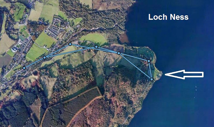
This shows my approximate track, leaving a track point every 10 minutes and straight-line connecting them.  The white arrow shows the location of Urquhart Castle.

It was a very cool morning with a brisk breeze, and before I returned, there was a steady drizzle coming down.  But that was OK.  It was not a moderate rain like the day before.  Along the way, once I left the Lewiston part of Drumnadrochit, I passed sheep farms and saw this rare black lamb.
Here was my first view of the castle.  You can see how steep the ridgelines are by the loch.  It is a beautiful spot, but castles were not sited for the view.  It would have strictly been a strategic decision.
Interested in a little "fixer-upper" with some history behind it?  Well, inquire within...  My wife told me that the tour they took was really good and well worth it.
The last photo is proof one more time that one must always have their camera at the ready.  As I strolled along back north, I spotted Nessie out in the loch, but before I could get my camera out, she disappeared into the bank of fog.  Oh, I could have been so rich!
I finished my walk in good spirits, having gotten the day off to a great start.  It got even better with another fabulous breakfast, and then we got on the road to drive to Stirling, where we would be for the last few days of the trip.

Monday, June 2, 2014

Balmacaan Wood Trails, Drumnadrochit

After walking to the Falls of Divach, the second part of my Drumnadrochit hike on May 21 was along the forest pathways in the Craigmonie and Balmacaan woodlands.  Combined, the two made for a lovely 6-7 mile hike in the rain, closer to 7 miles, I would say - and maybe a bit more than that.  I was pretty wet at the end, but happy do have done such a nice hike.  I am sure that there is a local group of volunteers that maintain these trails, and they do a wonderful job of it.

The visitor center gave me a basic trail map.  After the falls, I started near the bottom right of the map where the blue and white trails come together.  I had previously walked the white loop the night before as a leg stretcher.  I headed over to the west side, up the blue trail to the green, looped around that and then completed the red loop.  Lovely place!  The trail map said that badgers, roe deer, pine marten, and red squirrels are in these woods, so I was hopeful of a sighting. But the only wildlife I saw were a few small birds and an unidentified woodpecker, although birdsong was my near-constant companion.
Through really cool satellite technology from DeLorme, I was able to capture my basic track for the hike.  The light blue arrow is my approximate starting point from Rowan Cottage.  Starting 10 minutes later, I captured a track point every 10 minutes.  The software connects them with straight lines, so it is not exact route, but a good approximation.  The Falls of Divach, my first stop, are near the bottom left with the pink arrow.  The approximate location of Craig Monie is at the left arrow.  Loch Ness is to the east.  The light blue lines connect the track point.  Pretty cool, eh?

Right here, I walk through deciduous woodland with carpets of May wildflowers.
Where the red, blue, and green trails come together, there is a pair of huge redwood trees.  How big?  Well, I placed my hat and trekking poles against one of them so that you can get an idea.
I believe that this view was from the redwoods looking out towards Loch Ness.
The trails could be fairly steep in places with some climbing.  There was also a fair bit of mud from time to time.  As the elevation increased, the trees have way more to conifers like these,
and these.
There were only two places I came to on these trails with viewpoints.  This one is of Milton, originally a planned village towards the end of the 18th century.
The second and more spectacular viewpoint was Craig Monie.  I believe that "craig" means peak, and "Monie" was the name of a Norse prince killed in a battle on this spot.  What a lovely place to die, although I doubt that his cause of death was so lovely.  See Loch Ness?  Do you see Nessie in the upper right of the lake?  Neither do I!
This is the panoramic view from Craig Monie.
Mother Nature sure has some lovely carpets in her home, does she not?  These may  be blue bells.
I really loved this hike!  Combined with the waterfall walk, I was occupied for a good three hours.  A little rain?  Who cares? I was hiking in bonnie Scotland!

Sunday, June 1, 2014

Falls of Divach

My rule for saying I officially did a hike is that is must be at least four miles long.  Not that I won't write about and enjoy shorter hikes, of course, but for it to count towards my goals, that is my rule.  So for me to say that I had been hiking in Scotland, I had to get in a four mile hike, and time was running out.  We missed all the potential hiking around Loch Lomand because of the airline action.  The drive up to Isle of Skye was in the rain, and long, with no time to get in a four mile hike anyway, and then on Isle of Skye, I elected to do the drive-by touring to see more of the spectacular scenery.  And while I got in a couple of nice hikes on the way to Drumnadrochit, neither was close to four miles.

So when Wednesday, May 21 dawned, I knew this was it.  The rest of our trip after today would be in more urban areas.  It was raining steadily and cool.  The others decided to tour Urquhart Castle and then do a boat cruise on Loch Ness.  I elected to go for a 6-7 mile hike instead and meet them later so that we could tour Culloden Battlefield, east of Inverness, together in the afternoon.  So after an amazing breakfast, I headed out from our bed and breakfast, Rowan Cottage.  Did I say it was fabulous already?  :^) 

My hike was two distinctive parts, the Falls of Divach and the Craigmonie and Balcacaan Woodlands.  It was one continuous hike, but I will do two posts, one for each section.

From Rowan Cottage (did I mention that it is fantastic?) I walked through the Lewiston section of Drumnadrochit.  The hike to the falls was about a mile and a half, and 95% of it was along bucolic Scottish roads.  I only saw one or two cars as I walked steadily uphill to the falls.  There were cottages and lovely homes like this one closer to town.
And along the way, I passed a lot of pastures with sheep in them, like this ram:
Shortly after that, I spotted this little lamb, shivering in the rain and all alone.  He was outside the fence by the road.  I hoped that he would find his mom, or that the shepperd would take care of him later. 
I finally left the road for a short path to the falls,
which were most impressive.  They were over 100 feet (30+ meters) tall,
and they thundered into a pool.
I stood in the rain and watched the falls for about 10 minutes, then turned and reversed my course, downhill this time, passing the same lovely scenery and sheep pastures.
As I got back to the town, I turned left to head to the trail system of the Craigmonie and Balmacaan Woodland.  This would be on a lovely system of forest trails, and I really enjoyed it, despite the steady, cool rain.  More about that later.

Dog Falls in Glen Affric

After our short morning hike to the falls on the River Moriston, we continued driving up to lovely village of Drumnadrochit, arriving early afternoon on Tuesday, May 20.  We found the Bed and Breakfast that we would stay in for two nights - the amazingly great Rowan Cottage, which I highly recommend - and then my sister-in-law suggested driving into Glen Affric for a hike to spectacular Plodda Falls.

If I could miraculously be sent back to Scotland for just one day, it would be back to Glen Affric with all of my hiking gear, where I would hike all day, rain or shine.  It is supposed to be the most beautiful glen in all of Scotland, and there are lochs and forest paths all over, as well as some mountains. The road in from Cannich is slow and single track, meaning wide enough for one vehicle at a time with turn-outs to allow passing.  We somehow missed the turnoff for Plodda Falls and decided to hike to Dog Falls instead.

The weather was the best of the entire trip - mostly sunny and temperatures in the low 60's, the warmest day by far of the 8 or 9 that we were in Scotland, and one of only two mostly sunny days.  The map below shows the hike location at the blue arrowhead just left of center.  You can see Loch Ness to the east.  You can drive as far as Loch Affric, which must be beautiful and has a 10 mile trail circumnavigating it.
We parked the car at the car park / picnic area along the picturesque stream and started hiking, passing this nice stand of birch trees - probably my favorite tree - in a while.  Shortly after this, the lassies decided to turn back and spend time chatting at the picnic area, and the laddies continued hiking.
Here is a view of the stream as it flows towards the River Glass, Loch Ness, and, ultimately, the North Sea.
Dog Falls is not a huge waterfall, unlike the Plodda Falls that was our original goal, but it was nice all the same as it pours through a narrow rock chute.
After seeing the falls, my brother-in-law and I decided to continue to the Coire Loch viewpoint.  This is a small, circular loch nestled in the forest.  There were nice open views along the way.  It was very scenic.
Here is the nice view of Coire Loch that we attained for some minor climbing.
And here is a panorama of the area at the viewpoint of the loch.  It was so pretty there.
Can you see why I would love to return to Glen Affric and hike some more?

Friday, May 30, 2014

River Moriston Waterfall Walk


After leaving Balloch on Loch Lomand way too soon (and forgoing any more chance of hiking there due to our late arrival from Iceland), we hit the road on a rainy Sunday, May 18, and headed to the Isle of Skye.  Along the way, we drove through the absolutely spectacular Glen Coe, the rain never letting up, and past an incredible castle, Eilean Donan, to end up on the Isle of Skye.  We spent Monday, May 19, driving around the Isle of Skye to see the amazing scenery.  There are many hikes there, but I didn't have maps and decided to go with the others and see scenery from the car.

I was tempted to post some photos of the castles, cliffs, mountains, and seals that we saw in those two days, but this is a hiking blog, and I didn't hike during this time, unless you call walking around the grounds of the two castles as hiking.  So I suppose that I should not post those photos.

My next chance to hike was on Tuesday when we left Isle of Skye to head to Loch Ness.  It was a gorgeous day, and warm, with temperatures in the low 60's F.  Along the drive, and nearly to Loch Ness (see location below with the blue arrow head), we saw a chance to do a short but very scenic waterfall hike along the River Moriston.
Here is a closer view of where the hike is.  You should be able to see that the river flows between some steep hills as it flows the short distance from this point into Loch Ness.
For such a short hike - less than a mile loop - there was plenty of scenery.  Check out the double arched bridges just above the falls.
There is more river and less bridge in this photo.  The falls are not huge or tall, but very pretty all of the same.
There is lovely woodlands in this area along the trails,
along with some interesting roots with some of the trees.  It looks like severe erosion happened here.
You can get an idea of how steep the terrain is by the river from this shot.
There was this great stone hut along the River Moriston.
I went inside the stone hut and took this picture out its window of the river and the two arched bridges.
After ending our short hike, I sent to the bridge and took a picture down the river.  It is hard to see, but the stone hut is at the base of the tall conifer in the center of the photo.  After this hike, we headed out to Glen Affric to do another hike.  More about that in my next post.