Sunday, September 6, 2015

Tam MacArthur Ridge (Oregon)

On Thursday, August 13, I took my fifth Oregon hike with the Appalachian Mountain Club August Camp.  This time, we went up Tam MacArthur Ridge, a 5 mile total out and back that climbed 1,200 feet up to a ridgeline overlooking a lake.  It was a fun hike, once again, but a little lonely - thanks to a very basic mistake that yours truly made!

Let's start with a track of the hike.  We started and ended at Three Creek Lake.  See the big purple star on the map - more about that later.  Let's just say that I got very familiar with that area!

Here is a 3-D view of the hike.  We started and ended at the red arrow - up to the ridge and back out.

From a little bit of elevation over Three Creek Lake, here is a view of our destination - Tam MacArthur Ridge.

There were 13 of us on this hike.  Here are some of us admiring the views.

I am not sure, but I think this might be some of the Sisters Range.  Note the glaciers.  South Sister is the third highest mountain in Oregon, and I think is the highest that can be hiked without technical skills.

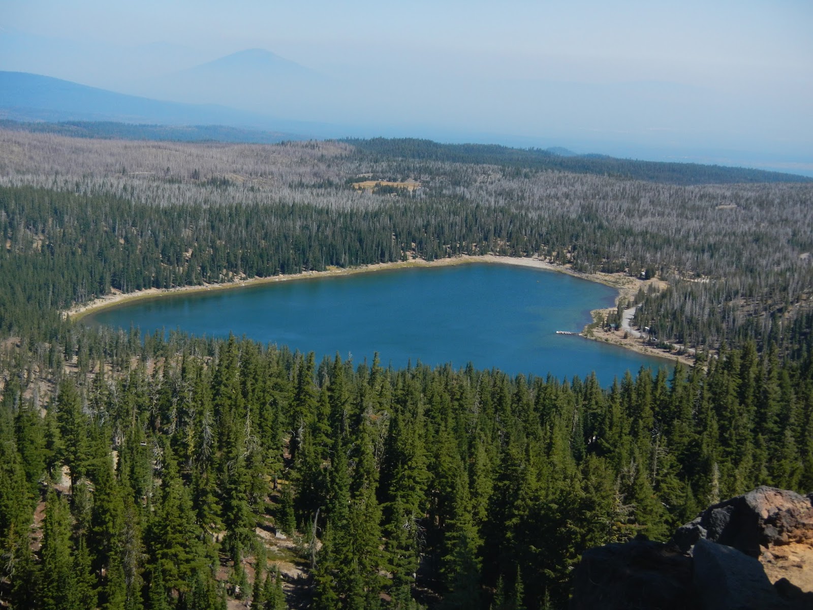
Three Creek Lake lies 1,200 feet below.
I mentioned that there were 13 of us?  Well, by the time I took the pictures above and the one below, I was in a group size of one, thanks to a decision making error on my part.

A group that large gets a little strung out.  I was probably in the middle, with about 6-7 ahead of me.  I came around a bend, and there were three of them sitting on a log in a shady spot.  One of them said "We're taking a little break - men to the right, women to the left."  I counted 3, subtracted from the number ahead of me, and realized that there were 3 or 4 still ahead.  I didn't need a bathroom break, so I kept walking to catch the others.  Mistake #1.  I walked.  And walked.  I came to a trail junction with a horse trail.  Odd that no one was waiting at the junction. So I kept walking.  Mistake #2.  After a good 20-25 minutes, having come to the ridge without meeting anyone, it dawned on me that everyone was taking the break back in the woods, not just three hikers.  So I turned back, thinking I would just meet them on the trail.  So I walked back until I reached the spot where the break had been, and this is what I saw:

How had I missed them?  Then only thing I could think of is that they had taken the horse trail.  So I could either go back up hunting for them, or I could sit my butt down right here and wait.  Staying put was the clear winner, even though I would miss out on more scenery.  So I sat in the shade and relaxed - this is where the purple star on the route map is.  I ate lunch.  I explored right around a bit - leaving my pack at the log.  I talked to people who were hiking up and down.  If they hiked up, I asked them to look for a group of 12 and tell them that Art was fine and waiting for them down the trail.  I even saw a couple of riders:

My one fear was that they would divide up and search for me at the top, but I was pretty sure that Eva, our hike leader, would not let that happen.  Better to have one person separated from the group than three or four.  And after two hours of waiting, who should appear than the other dozen!  I was happy to see them!

We hiked down together, pausing for a few more wonderful views:

And we ended the hot day with a cool and refreshing swim in Three Creek Lake, with Tam MacArthur Ridge looming above us.

I made several fundamental mistakes to get separated from the others.  First, I assumed that only three were taking a break - and worse, I didn't ask for confirmation.  Eva gave me advice afterwards when we linked back up - don't count the people at a break, count the packs.  And memorize your hike leader's pack!  If it is on the ground, then the hike leader is nearby.  Second, I did not stop at the trail junction, assuming that the others were just ahead and hadn't stopped because it was a horse trail.

But I also did several things right.  First, I eventually realized that I was ahead and instead of keeping going or waiting where I was, I backtracked.  Second, when I got back to the break spot and everyone was gone, I waited there instead of going back up looking for them all.  And third, I sent word up with ascending hikers, and as it turned out, at least one of them contacted the group and told them that I was fine and waiting.

It was not my most fun day of the week, but fun enough, and I learned some things!

Thursday, September 3, 2015

Paulina Lake Circuit (Oregon)

On the fourth day of hiking in Oregon, Wednesday, August 12, it was time to take a break from elevation gain but still hike in a scenic place.  The 8.5 mile loop around Paulina Lake fit the bill to a tee!

Paulina Lake is in the caldera of a volcano, and there is plenty of volcanic activity in the area.  We even hiked up and past a collapsed volcanic rim, and we found areas of obsidian, which is jet black volcanic glass.  And while we almost always had great scenery, we only gained about 600 feet for the trip.  This map shows our track, in a counter clockwise direction, starting and ending at the purple star.  Can you see the small crater that we hiked along?  It is southeast of the lake where the trail meanders away from the lake.  It was covered by trees.

There were six of us on the hike, and it was a fun group.  We were in the van together about 3.5 hours coming and going - it was the longest drive I had all week to the trailhead.  Most of the people slept on the way back to camp.

After three straight days hiking in the mountains, I really was looking forward to the hike around the volcanic lake.  The crater formed by the volcano exploding is called the caldera, and someone told me that a lake in a caldera, Yellowstone Lake being an outstanding example, is called a caldron.


For the first couple of miles of hiking, we saw a lot of use by campers and boaters.  It is a very popular recreation area.  I saw a number of great campsites, all with water access, along the way.

There is something about hiking along a beautiful lakeshore.

In a couple of sections, we climbed a bit, and got some really nice views looking down.


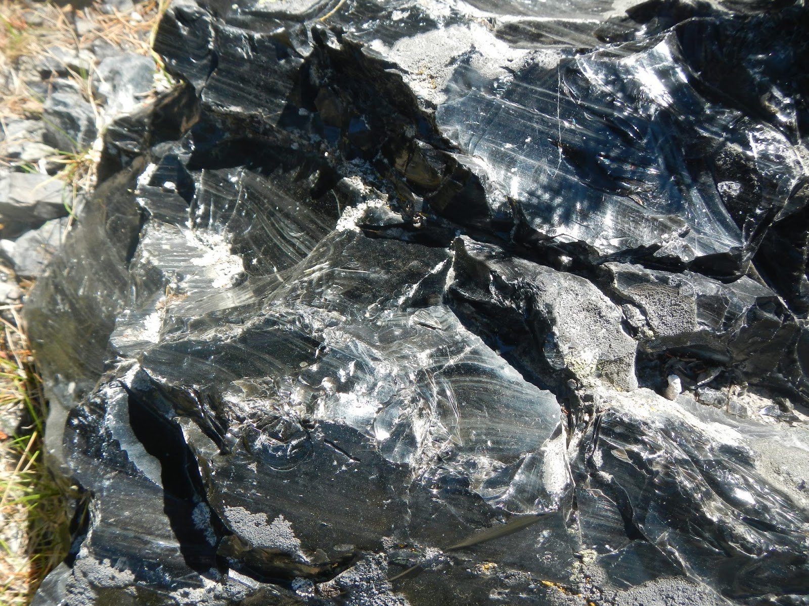
Here is a big chunk of obsidian, volcanic glass.  People used to make tools and trade it.  It is amazing stuff - hard as flint, jet black, shines like diamonds, cuts like a knife.

More lakeshore views, as we neared a great spot for lunch back down by the lake.  A couple of us went in for a swim, and I soaked my feet.

It's hard to see them, but there was a group of several dozen mergansers fishing out in the lake.

I didn't go inside, but I have a feeling that this would be a great place to be for a meal with a view.

Other than the long drive - I was the driver on the way back so could not nap - this was a perfect day of being out in the great outdoors.  It was another fabulous day on the Oregon trails!

Wednesday, September 2, 2015

Hackleman Old Growth Grove (Oregon)

On Tuesday, August 11, we had time after the hike up Iron Mountain to visit the Hackleman Old Growth Grove.  This was only about a one mile loop, so I am not going provide a topo map, but it was fascinating because the Douglas fir here were up to 500 years old - basically seedlings when Chris Columbus came over this way!

I guess since I finally had a day of hiking without falling, something had to happen, and it did.  I, and one other, were attacked by yellow jackets when we posed by one of the trees!  I got stung twice, and she got stung once.  Interesting enough, we talked to at least three other people on other hikes who were stung that day.  I didn't feel like I had done something wrong, but clearly, I violated some important protocol shared by these wasps!  Or maybe it was payback for killing the one that crawled into my sandwich bag the day before up at Rooster Rock.

For only a mile of hiking here, we sure saw some pretty forest land!  Here are a few photos.


Sunday, August 30, 2015

Iron Mountain Loop (Oregon)

On August 11, my third day of hiking in Central Oregon at AMC August Camp, it was tempting to take a break and do something a little easier, like the trip into Bend for biking, kayaking, and brews!  But instead, I hiked the Iron Mountain loop trail, and am I glad I did, because it was my favorite hike of the week.

After two out and backs, a loop trail was a great change!  You are always seeing something new.  The only out and back part was a short spur to the summit of Iron Mountain, with many switchbacks as we gained about 600 feet in a half mile.  The total hike was 7.3 miles, and we went through some mature forests, open wildflower meadows with great views, and to the top of Iron Mountain with a deck on top and 360 degree, if hazy, views.

Here is a track of our hike.  The start and end is marked with the red star, and the red arrow marks the direction of travel (counter-clockwise).  A purple star marks our main objective, the summit of Iron Mountain with its wonderful views.

Here is a three dimensional view of the area.  We hiked across the saddle between Cone Peak and Iron Mountain.  The red star  indicates where we started and ended.

We started the hike through mature forest.  Very relaxing and pretty.

After some climbing, we arrived at an open area with views, including of Cone Peak to the north, and...

Iron Mountain to the west.  That is where we hoped to have lunch.

The views from the saddle here were really great.

The shaggy-barked Alaskan cedar is rare in Oregon but fairly common in this area, our naturalist hike leader volunteer told us.  By the way, all of the hike leaders were great.

This whole region seemed to be the results on volcanos.  Look at all of this volcanic rock.

As we started the steep switchbacks up Iron Mountain, some wonderful views began to come.

Pearly everlasting is the name of this wildflower - a pretty name for a pretty flower!

You can see how hazy it was there.  Some of this is the result of forest fires.

I was the last to reach the summit with its wonderful deck.

Even with the haze, the views were plenty gorgeous from the top.

We saw lots of wildflowers on this hike.

Near the end of our hike, I think that I am celebrating actually completing a hike without taking a spill!  Also, I wanted to show that there some big trees in this area.  However, the short hike that we did after completing this one had some truly huge trees - 500 year old Douglas fir!

This hike had everything but wildlife - a good group of hikers to enjoy it with, a great hike leader, wonderfully varied views and scenery, a great cardio workout, beautiful forests, lovely open views, mountaintop views, and gorgeous wildflowers.  For that reason, it was my favorite hike of the week, although they were all so good that it is difficult to choose.  One thing I found about August Camp - you can randomly pick a hike each night and not go wrong!

Monday, August 24, 2015

Rooster Rock (Oregon)

The second AMC August Camp hike of the week, Monday August 10, was up to Rooster Rock.  It was another out and back hike, 3.2 miles each way, uphill on the way out, and downhill on the way back.  The 2,300 feet that we gained hiking up to Rooster Rock was all lost on the return.  It was rated as a moderate hike.  The views at the top were good but not as spectacular as the Dome Rock hike.  However, we explored a kind of secret side trail that led to some amazing views.

Here is a track of the hike, starting at the lower left with Rooster Rock on the right.  The hike climbed steadily through a nice forest and only had views at the very top.  The secret trail led to the north about a half mile from the view point.  The purple star shows the approximate location of the end of the side trail with the fabulous view.


Here is a three dimensional view of the hike.  I've marked the approximate location of Rooster Rock.  There was a huge cliff face there, as well as other giant rocks.

The start of the hike featured large trees hanging with Old Man's Beard lichens.

I hiked with five others.  At this point, I snapped a shot of some of them ahead of me in the thick forest.

This hike had about four major obstacles to cross on the trail.  We had to climb over some very large logs, at steep angles, and for this one, we all crawled under it using various techniques: a roll, a crab crawl, and so forth.

Very close to the summit, we paused to look at the huge cliff and rocks that made up part of Rooster Rock.

The summit had nice views to the east-south-east, which was also the direction that the sun was shining from.  It was a good lunch spot, and several yellow jackets also showed up to see if they could steal some food.  One crawled into my sandwich bag, which crossed a line, so I dispatched her.  Would I perhaps find some bad karma from this later?

After lunch, we decided to see if we could follow the secret side trail from the summit the north.  The trail book suggested a possible view of Rabbit Ears.  After a while, sure enough, we spotted the two giant pillars of stone partially visible through the trees.  These columns are very popular with rock climbers.  For me, attempting it would lead to an early death.

A while past Rabbit Ears, the trail seemed to end.  I was in the lead, and it looked like we would have to risk climbing over this huge rock.  Good views seemed to be ahead, but were they worth the risk?  We decided not!  But then, a fellow hiker spotted a faint track to the right of the rock, and scouted it out.  It was steep and narrow, requiring caution, but was passible, so I followed him out there.

And am I glad I did, because there was a fabulous view!  The two of us who went over there took turns snapping photographs of each other.  It was literally a place where if you stepped about three feet backwards, it was a very, very long way down.  So we both went very slow and carefully here.

Being an out and back, the trip back to the car was a repeat of the trip up, except downhill.  Sound easy?  Well, we still had to climb over and under some big logs, and at the very start, I took a step in a patch of gravel on a steep slope that was like stepping on ball bearings.  I took another quick and painful fall, gashing my elbow open.  It bled enough that our trip leader got out her first aid kit and patched in up.  Two weeks later, I still have a big scab on my elbow.  Two hikes, two days, two falls, two scraped up arms!

Did that spoil the trip? Heck no!  I had a fabulous time doing another great hike, and I wondered what tomorrow would bring.  It turned out that it would bring the best hike of the whole week!

Sunday, August 23, 2015

Dome Rock (Oregon)

The first AMC August Camp hike of the week, Sunday August 9, was up Dome Rock.  It was an out and back hike, 2.6 miles each way, mostly uphill on the way out, and downhill on the way back.  The 1,500 feet that we gained hiking up to Dome Rock was all lost on the return.  It was rated as an easy hike, but the elevation gain didn't seem that easy, plus I was jet-lagged and hadn't slept hardly at all during the night.  But the views at the top were simply spectacular!

Here is a track of the hike, starting at the left with Dome Rock on the right.  Just to reach the trailhead for the unmarked trail was a bit of an adventure, ending with four miles on a rough gravel road.  The trail to Tumble Lake would have been very pretty, but would mean dropping over 1,000 feet to the lake and then climbing back out.


This is a 3-dimensional view of the area, with Dome Rock marked on the right.

We had a dozen people on our hike.  The trail was not marked, and early on, we took a wrong turn here.  It took over 30 minutes to figure out the correct direction, largely helped by my DeLorme GPS app on my iPhone.  It was a great group of people to hike with.

Much of the trail was narrow and without a view, but once the views started coming, they were amazing.  Here is a view of Tumble Lake over 2,000 feet below us.

There were also some cool rock formations.

From the top of Dome Rock were 360 degree views that were just fabulous.


The views were so nice that I couldn't resist asking for someone to add me to one.  Hopefully, it does not spoil the picture.

Many of us wanted to linger on the beautiful summit a bit longer, but our leader was worried about weather coming in, so she insisted that we head down after about 20 minutes.  I had a scary moment on the way down.  In a very narrow and steep section of the trail, a marmot had undercut the trail and it gave way under my left foot.  The slope was about 60 degrees, and I slid about 20 feet before I could stop my momentum.  Other than a scraped up arm, I was all right, but my adrenalin sure spiked during that time!

Dome Rock was a fantastic way to begin a week of hiking in Central Oregon!