Thursday, January 24, 2019

Day Hiking at Powhattan

Late last week, my friend Doug and I decided to go for a short hike Friday in Powhatan State Park, southwest of Richmond.  Doug had Friday off from work, and I, well, I have every day that includes a "Y" off now, generally.  We met up about 11:00 and headed to the park.  Our focus would be the Old Cabin, Big Woods, and Pine Trails, but we also hiked a bit along the river after that.

After years of trouble-free operation, my inReach is no longer mapping my tracks accurately much of the time, adding all sorts of additional track lines and garbling the results, so I won't show a map.  We did hike about 8 miles and did a bit of exploring in the woods when we could not find the connection between the Old Cabin and Pine Trails.  Eventually we did, although unlike is normally the case in our state parks, it was very poorly marked.

Here are some photos of this hike.  As far as wildlife, we didn't see any but did hear a number of birds (lots of the big pileated woodpeckers, downy woodpeckers, white-breasted nuthatch, Carolina wren).

Doug on the trail...

Stark winter tree branches

The snow of two weekends ago was all but gone.

The old cabin site.  I wonder who lived here and how their lives were?

Hiking along the Pine Trail.

Skunk cabbage bulb.  Yeah, they smell a bit like skunks, but a sure sign of the spring to come.

Interesting fungi, almost like a fan.

All of the above photos were of the first hike of the day.  The second was along the River and Gold Mine Trails, and was shorter.

We saw at least 3-4 places where the rarely seen moles, a star-nosed perhaps, tunneled in the darkness hunting for worms and grubs.

There is a memorial to our friend Holly Walker, who did exceptional work for State Parks as a naturalist, along the River Trail.  She is gone too soon and missed by many people.

It's a lovely spot to memorialize our friend.

The River Trail is scenic and easy to hike.

I'm glad that Doug suggested on hiking together last Friday and doing so before the rains of Saturday arrived.

Saturday, January 12, 2019

Up the Staunton River Valley

Not three months ago, I cruised up The Priest from the Tye River Valley, a climb of 3,100 feet in about 4 miles, and while I didn't sprint up the mountain, I hiked steadily and never once felt the need to stop to catch my breath.  But that was then, this was now.  Yesterday, I joined six others for a hike over Bear Church Rock (elevation about 2,800 feet) from the Staunton River (elevation about 900 feet.)  I felt fine for the first 2.7 miles, although I was too warm from three layers and heavy gloves despite the lower than 20 degrees F temperature.  I removed a damp shirt, removed my hat, and started the final uphill climb of about 1,000 feet in 1.2 miles.  And I could feel myself struggling, bringing up the rear.  Was it the less than challenging hiking of the last couple of months? Two to three weeks the last part of December with a bad cold?  Just an off day?  Well, I'm not sure, but I felt like, while I could complete the hike, I would slow the group down.  So I told the hike leader that I would be hiking back 1.2 miles to the junction of the Jones Mountain and Staunton River Trails, and wait for them there, or possibly from there, I would hike west bound on the Staunton River Trail and meet them as they completed the loop part of this "lollipop" hike.  We had lunch together about 11:00 and then they hit the trail at 11:20 and I reversed direction.  It was cold and windy on the mountain, and I was back to all my layers, my hat, and heavy gloves.  I'd last hiked here in April, on a backpacking trip, so the trails were familiar to me, although I did pick up a new 1.8 miles towards my SNP 500 goal.

Here is a kind of funky looking track for the hike:

Some explanations - the parking area is at the blue star (lower right).  The part of the hike I did is the blue trackline (with one exception).  Bear Church Rock is at the red circle.  From there, I back-tracked down the Jones Mountain Trail, and the rest of the group headed west towards The Sag (orange track and directional arrow).  See the blue track heading north that I highlighted in purple?  Well, that is a mystery.  I never walked that.  It would have meant fording the river and bushwacking up the side of a steep mountain.  My inReach thinks that I did it, but I absolutely did not.  The full hike was about 13.3 miles. I hiked about 10.4 miles.  From Bear Church Rock, the group would have to hike 6.7 miles to get to our meeting point, just 1.2 miles for me back down the trail.  Since they left at 11:20, I was thinking I would see them again about 2:45.

Here is our group at the trailhead:


This is the lovely Staunton River along the first part of the hike.

The view from Bear Church Rock is always amazing.  Old Rag is visible in the distant a little bit to the right of center.  We had climbed 1,900 feet to get there and covered 3.9 miles.

After I headed back down, my strategy was to wear all of my layers but to hike slowly.  Therefore, I would generate enough heat to keep warm and slowly dry my very damp shirt.  Once I got back to the Staunton River Trail, it was about noon.  How would I spend the next several hours?  Well, I started out by sitting in the faint sun.  I was fairly warm despite temperatures in the low 20's.  I studied the map.  I recalculated how far the group had to go and how far the total hike would be.  I arrived at 13.3 miles, which is longer than I had believed the hike to be.  I looked for animals and listened for birds.  But the mountains in winter were very quiet.  I was up there outside for 9.5 hours.  In that time, I saw a downy woodpecker, a short-tailed shrew, and three deer.  I heard a Carolina wren, a chickadee, a pileated woodpecker, a raven, and several downy woodpeckers.  That's it!  I had some snacks and ate those to help generate some heat.  I'd not packed my stove, figuring that I would not be able to use it and keep up with the group.  I sure wished that I had had it.  A couple of mugs of hot tea would have been fantastic.  When I started to get too cool, I would take a short and slow walk.

Eventually, I decided to hike west along the trail and meet them maybe a mile up.  I calculated that they would get to that point about 2:20, so about 1:30, I started hiking that way.  Along the way, I had to cross some minor streams, sometimes armored in ice.


After about 0.8 miles, I came to a major crossing of the river.  It was a little after 2:00.  My shirt was finally just about dry.  I decided that it was pointless trying to cross and maybe fall in, since I didn't have to.  It was a pretty spot, so I waited there.

Every few minutes to the river, I would walk back down the trail for two minutes and then turn around and walk back.  So that kept me warm (a mug of hot tea would have worked better).  By 2:30, no one had shown up.  So I repeated that routine until about 3:00, then decided to walk back down to the meeting spot.  Once I got there, I walked around a bit and then found a very comfortable spot to sit, a flattened log with a tree behind it for back support.  I also got my headlamp out and put the batteries in, because I was beginning to think that we would be finishing the hike in the dark.  I'd no sooner sat down and put my back against the tree when, presto, there they were!  I was glad to see them and to know that they were all okay, and that we could get moving - in daylight!

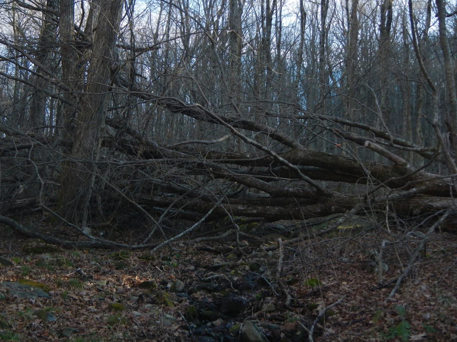
The hike back from there was very easy, all downhill, losing about 900 feet over 2.7 miles, all along the river with its winter beauty.


It was a fun hike.  While I was disappointed to not do the full hike, I still got in 10+ miles of walking in the mountains and plenty of fresh air.  I also think I made the right call in turning back and waiting.  But the new year is here, and it is time to start getting back into hiking shape.  This trip, and being over my long cold, is a good start.

Also, there are some trails up here I've never hiked, so a return trip - perhaps an overnight in warmer and leafier weather - will be in the cards.

Thursday, January 10, 2019

Getting Off on the Right Foot!

Virginia, and maybe other states, has a tradition of encouraging people to hike on New Year's Day.  The state parks are free, for example, and many - perhaps all - of them have ranger led hikes that day.  The Old Dominion Trail Club had a hike scheduled for January 1, and my friend Doug talked me into going.  Originally, I didn't plan on going because hiking with a group of 30 or 35 is not that appealing, but I am glad I went.

The hike was about four miles on a brand new trail, the Co-Op Trail, which is in Pocahontas State Park just south of Richmond.  Jeff, the man who led the hike, is very active with trail maintenance there, and did a lot of work to make this new trail a reality.  It was good to go and see the great work they had all done.  Here is the location of this trail:

And here is the track of the hike, more or less an out and back with some loops, starting and ending at the red star.

We had a big group for this hike.  I'm in the middle of the pack here.

I think it was Altria that paid for the materials to build this impressive stream crossing.

The Co-Op Trail is marked in pink.

A lot of this very pleasant hike has water views.

Where there is water and gentle slopes, there are usually beaver.  Busy as a beaver comes to mind.  North America's largest rodent, and the second largest rodent in the world, stay plenty busy.

More water views on the return.

This is a very easy and very pleasant hike.  I had a great time, and I felt like I got the New Year started on the right foot (or maybe it was my left?)

Two days later, I did a solo hike to Cumberland Marsh Natural Area.  The sighting of the day were two bald eagles.  Since I have documented that hike several times, I won't again.

Tuesday, January 8, 2019

Out with the Old, in with the New!

I was lucky enough to retire during 2018, and thus got to hike more.  To summarize:

27 hikes total for 356.6 miles.
5 were backpacking trips of two to nine days for 238.1 miles
The other 22 hikes were day hikes for 118.5 miles.

I haven't thought much about goals for 2019.  I would like to hit 400 miles though, and maybe half of that backpacking.  I'd like to get out backpacking more often but maybe not for as many long trips.  Of my backpacking trips, two involved a total of four nights, and the other three involved a total of 20 nights.

I'd like to complete all of the miles in at least one section of Shenandoah National Park, probably the southern section.  I hope to do that by camping out more so I can hike several days for each trip all the way up to the mountains.

I'd like to go on at least one week-long backpacking trip.

I did more hiking with groups than solo, and I'd like to continue that trend.  And I led a number of hikes last year, including 3 of the backpacking trips.  I want to keep leading hikes, but would like to get some first aid training.

HAPPY NEW YEAR!

Saturday, December 8, 2018

Let it Snow!

After hiking solo in Shenandoah National Park on Monday, I was ready for a group hike, and joined the Old Dominion Appalachian Trail Club Wednesday to hike in Bear Creek Lake State Park.  Sorry, no bears, unlike my Monday hiking adventure.  As we gathered at the meeting spot southwest of Richmond, we noted a few snow flakes drifting along.  And as we drove along, we soon were in a steady snowfall.  By the time we arrived at the park 45 minutes later, snow covered everything, and it was still coming down.  It was quite beautiful.

My inReach is not creating tracks correctly for some reason, but here is the location of the park (orange circle) west of Richmond:

We did two different loops - a morning loop of 4.8 miles, then we ate lunch, and then a 1.8 mile afternoon loop.  We mainly walked through deciduous forest, with some water views.  The snow was beautiful.


Our group of a dozen really enjoyed our hikes.


Having the snow turned what would have been a fairly routine hike into a winter wonderland.  I really enjoyed hiking here.


About an hour after starting our hike, the snow had stopped and even seemed to be melting a bit.

After a nice trail lunch under a park shelter - chilly but at least dry - we started the afternoon hike.  By that time, most of the snow had totally melted.  We walked by the spillway of the dam holding Bear Creek Lake back, then the lakes itself.  There were some nice campsites along the lake shore.


We also admired the work of the Civilian Conservation Corps and Work Progress Administration from the 1930's.  They actually built a lot of the infrastructure of the first six Virginia State Parks.


I really enjoyed hiking here, and will definitely get back here for more trips.

Thursday, December 6, 2018

Two Shenandoah Hikes

I've done a fair amount of hiking since August, but was amazed to realize that I had not hiked in Shenandoah National Park since August 4!  Time to rectify that, and add a few miles to my "SNP 500" quest, so I hiked a couple areas that I had never been to.  The weather was cool but not cold, and the trails were clear.  The southern part of the park has been hammered by ice and wind storms, the Skyline Drive there was closed, and trees are down all over, but the central part of the park is fine right now.  Here is where I hiked:

The blue arrow points to the Skyline Drive in the central third of the park.  I entered at Route 33 (Swift Run Gap), and did a section of the Appalachian Trail and the Saddleback Mountain Trail (red circle) and a trail called the Meadows School Trail (blue circle).  The first hike was about 8 miles total, and the latter was 1.5 miles each way for a total of 3 miles.  My SNP 500 goal is now below 300 miles to go.  Unfortunately, my inReach is not producing a clear track map right now for some reason, so I am not showing the tracks for the hikes - they are inaccurate.

The trees are now totally bare.  This is the Appalachian Trail near Swift Run Gap.  Along the hike, I saw a pileated woodpecker and a white-breasted nuthatch.  Other than that, there was little wildlife to be seen or heard for most of the hike.

One thing I like about this time of the year is that you can see a long way through the woods, and even distant views.

I hiked to Route 33 at Swift Run Gap, then turned around.  It was a pretty easy hike, maybe losing and gaining about 700 feet over about four miles each way.

The Saddleback Mountain Trail leaves the AT and runs east of that mountain.  I ran into two women doing a day hike in this area, but they were the only people I saw over more than 11 miles of hiking this past Monday.

A short distance before joining the AT again, I came on this locked shelter.  The Potomac Appalachian Trail Club uses this to camp out when doing trail maintenance in this area.

The shelter is locked but I saw no harm in having hot chocolate and lunch here.  I got water from the spring, got out my Jetboil stove, and made a nice, hot drink.  Nothing like hot chocolate on a chilly day up in the mountains.  I saw a deer moving through the forest, and shortly after I started hiking again, two nice does ran right across the trail in front of me.  They were too quick for me to snag a photo, but that was okay, because an even more interesting wildlife encounter was ahead.

After getting back to the car at the South River Falls Picnic Area, I headed north on the Skyline Drive for about 5-6 miles for the next hike.  Ahead on the road, I saw a black animal in the middle of the road.  No doubt what it was, so I slowed down - I always go the speed limit of 35 in the park so I am less likely to kill an animal, but I see lots of people doing 50-55 - and got my camera ready.  As I pulled up, the small bear, which appeared to be a yearling, left the road and climbed up on the stone wall along the side.  It looked right at me!

Then, it turned and jumped off the wall on the other side.  It was small enough that I couldn't see it at that point.

The Meadows School Trail really doesn't have anything remarkable to recommend hiking it, other than I have to hike every trail and fire road in the park to earn my patch, so it seemed like a good day to just check this trail off the list.  It was 1.5 miles downhill about 900 feet, then 1.5 miles back uphill to the car.  Nothing special, other than any day we are healthy and alive, and out in the mountains is special.

This trail is not super-well maintained.  Note the deep ruts from storm runoff.  As a footnote, I brought my river shoes today and had no problem rock-hopping the few streams that I encountered, unlike my other recent hikes here where I was always having to wade across something, usually without my river shoes.

This large tree blocked the trail.  I made my way around it, as going over it would have been difficult.

Back on the Skyline Drive, I paused to admire the view of the Shenandoah Valley before heading for home.

It felt great to be back in Shenandoah National Park again.  This is likely my last hike of the year here.