Saturday, January 18, 2020

The Group Hike That Kind of Wasn't

My last hike of 2019 was December 8 at Powhatan State Park (I didn't post about it, but it was 7 miles).  Exactly a month later, I took my first hike of 2020.  My wife's health has improved enough in the last few weeks that we are okay with me heading out for fairly short hikes not too far from the house.  So, while I won't be going up to the mountains - too far and not as easy to stay in touch - Powhatan SP is only about a 35 minute drive and is within cell phone coverage.  And on that Wednesday, the Old Dominion Appalachian Trail Club was having a hike there of about 5 miles, gathering at 10:50.  Seemed perfect!

I hit the road and even got there about 5 minutes early.  As I pulled into the parking area, I was amazed to see so many other people there early as well.  The parking lot was full, but not a single person was in sight.  I pulled out my phone and checked the email: gather at 9:50.  Doh!!!!  Well, I was at the park, it was a pretty day, and I could still do a hike.  I looked at the map, planned my route, and started my feet moving.  And in about 1.5 miles, I encountered our big group coming the other way, so I hiked back to the cars with them, getting to chat with some of the club members.  After they left, I hit the trails again and hiked about 2 + more miles by myself.  Here is my route.  The star is the parking area, the big arrow to the red circle was my first hike, running into the ODATC at the red circle, where I turned and retraced my steps.  The loop at the top of the map was my second hike, solo.


The first part of the hike goes through open woods near the James River, and past some canoe-in and walk-in campsites.  One can camp here year round, I believe.

This park is a pleasant mixture of forest, riverfront, and open fields.

The stairs to nowhere?  Actually, this park is popular with horsewomen and horsemen, and my guess is that the steps are provided for easier mounting of one's horse.

As I walked along the edge between the field and the forest, I was delighted to see the ODATC hikers coming towards me, so I retraced my steps with them to the parking area.

Back on my own, I started out on the River Trail, then looped back through the forests and fields.

Here is a deep gully that likely contains an intermittent stream when heavy rains occur.

I really like going through the forest in the winter.  It's peaceful, although I do miss the bird song of spring and summer.  Birds calling are infrequent this time of year: a few pileated, red-bellied. and downy woodpeckers; Carolina chickadees; Carolina wrens; white-breasted nuthatches; tufted titmice; white-throated sparrows.

I was happy to get in a short (5.6 miles) hike, and also to run into fellow hikers, despite my senior moment about the time.  I'll try to go on a few other short hikes before my wife's surgery.  I may not write about them - for example, I got to Three Lake Park and Malvern Hill Battlefield in the past week.  Eventually, I'll be up in the mountains again, but not for a few months, I would guess.

Friday, January 3, 2020

Wrapping Up 2019

HAPPY NEW YEAR!

In 2019, I took over 5,000,000 steps, walking an estimated 2,470 miles.  Of this, 422 miles were hiking on trails, the first time I've ever hiked over 400 miles in a year.


Some other stats: I hiked 384 miles as day hikes, and only 38 miles while backpacking.  It was not a good year for backpacking.  I cancelled two trips when I got sick, another to go to my step-mother's memorial service, and at least two more when our cat got sick.  Maybe I'll manage more in 2020 - that's my goal at least, once I start hiking again.

I hiked 100 miles by myself, and 322 miles with groups, including 159 miles with the Old Dominion Appalachian Trail Club.  I went backpacking once with a group and once by myself.  I finished most of the trails in the Southern District of Shenandoah National Park.  I have about 200 miles left to hike in the entire park, which probably means hiking closer to 400 miles, since so many are out and back, or I have to repeat some sections I've already done to get to a trail that I haven't hiked yet.

My favorite hikes of the year?  The Grayson Highlands backpacking trip, my November backpacking trip over Rockytop, the ODATC hike on the AT from Stony Man to Thornton Gap, and the three Road Scholar hikes for June, July, and October - which I got paid for!

Sunday, December 29, 2019

New Map

I'm glad I saw the bear up close on my last hike, because I won't be hiking for a while.  My wife needs surgery and so I will staying close to home for some time.  In the meanwhile, I can study maps and dream of days to come on the trail.  Speaking of maps, in my Christmas stocking was a Purple Lizard topographic map of the Laurel Highlands region of Pennsylvania, where I backpacked twice in 2018.  The map includes the southern 35 miles or so of the wonderful Laurel Highlands Hiking Trail.  But the map contains the following health warning: "Continued use of Lizard Maps may result in an inability to stay indoors and an uncontrollable desire to explore.  Your skin may become covered with dust and dirt.  Mild euphoria can make it difficult to relate time and distance.  A perpetual smile may alter your definition of weather.  Your entire worldview may change.  There is a potential of all of these to occur simultaneously and without warning.  This is why we are warning you now."

Okay, I've been warned.  Bring it on!


Monday, December 9, 2019

Four Hikes, and a Bear

I'm always happy to hit the trails in the mountains, but last Tuesday, I was a little less excited than usual.  My goal was strictly to hike several short trails to check them off my SNP 500 list.  None of them seemed overly amazing - they were all short sections, out and back, repeating the same ground each time.  Here are the trails I hiked, for a total of about 10 miles, with a loss and gain of 1,800 - 2,000 feet:

Eaton Hollow
Simmons Gap Fire Road West (Beldor Road)
Pinefield Hut
Browns Gap Fire Road (east of Doyles River)

On this track, they are located in order north to south to give an idea of their locations, all in the Southern District of Shenandoah National Park:


Yet, despite my lack of enthusiasm, each of these four little hikes yielded a good memory.  On Eaton Hollow, I hiked to a cool PATC camp building.  On the Simmons Gap hike, I encountered two ladies hiking and had an enjoyable chat.  On the hike to the hut, I enjoyed a nice lunch break at a picnic table.  And on the Browns Gap hike, I encountered a bear close up, my first great look at a bear in a long time.

The Eaton Hollow hike was about a half mile each way.  There was a nice view right at the start, followed by a mostly gentle descent to the camp area:

At the turn-around point, I reached the Schairer Trail Center of the Potomac Appalachian Trail Club (PATC).  I don't know what they do here, but doesn't it look inviting?

Here is the view from the front porch:

This photo gives a good idea of the setting.

Next, I drove a few miles south to Simmons Gap, where these three deer gave me a look over.

I started hiking downhill along the fire road, heading west.

On the way back up, against all expectations, I met two ladies hiking down.  I'll call them K and S.  Why in the world was anyone else on this trail on a cold Tuesday morning?  Well, the logical explanation is that they were also attempting to hike every trail in the park, and that was the case.  We had a very nice chat. K wore a cap with the pink breast cancer symbol, so I asked if she was a survivor, which she was.  I told her that I was a 17 year Hodgkin's lymphoma survivor, and she said that her husband has non-Hodgkin's lymphoma.  I told her about walking the 3-Day 60 mile Susan Komen walk in 2011 (in memory of my sister, Ann, who died from breast cancer that year), and also about doing marathons and half-marathons for Team in Training to raise money for blood cancer research.  And we also talked about hiking in the park, and working towards the SNP 500.  I think K was getting pretty close to finishing, and S - while not doing the formal miles - likes to help her and hike with her.  I still have about 200 miles to go.  I enjoyed meeting fellow hikers out there and getting to talk.  They were the only people I saw all day.

Next, I drove south a bit and hiked the short distance into the Pinefield Hut, a perfect spot for lunch.

Finally, there was time for one last hike, the east side of the Browns Gap Fire Road.  I'd been by this spot at least a dozen times on my Doyles River hikes, including exactly a week ago with my friend Doug.  I left my car at the Doyles River trailhead, and dropped almost 700 feet like a stone to get to the fire road junction,

this time turning east instead of west.  The trail went almost two miles from here and dropped another 500 feet, although at a more pleasant pace.

Could there be a bear in this cave?  Maybe.  Did I stick my head in there to find out?  No., I did not!

 This was a very pleasant old road to hike along.

On one side was the steep Doyles River Valley.  I could hear the falls far below, and even crossed the Doyles River - easily rock hopped - as it flowed over the fire road.

I got some nice views across the valley at times.

The end of the road at the park boundary!  Check off one more trail towards the SNP 500.

On the hike back up, I got a treat.  I was trying to send my wife a message on the inReach but it was not going through.  So on that steep section, near the junction of the trail to the Doyles River Cabin, I stopped to get the message sent.  While I was stopped, I heard the sound of an animal in the leaves.  Squirrel?  No, something larger.  I waited and waited, and suddenly, there was a young bear about 100 feet off the trail.  I spent a while there, trying to get a good look for a photo.  Most of the time, he was partially hidden behind vegetation, but eventually, I got some good shots.  He was cautious but not fearful.  Up through the woods by the cabin, I could hear two men calling a dog and the dog barking.  The bear didn't seem concerned, and eventually ran across the trail about 50 feet from me and headed up towards the cabin.  Hopefully, he was not getting food from a human source.  This bear looked to me to be a second year cub, meaning his mom had recently kicked him out and he was having to make his own way in the world for the first time.  Seeing a bear is always a thrill!  This was my first sighting since June, and my first while hiking solo in several years.  If I hadn't stopped at that exact spot to send the message, I never would have seen this animal.


What a fun day in the mountains!  Meet some wonderful hikers and have a nice chat, and see a bear!  And check off about 4 more miles towards my SNP 500!  I'd call that a pretty good day!

Thursday, December 5, 2019

Map Summary of Four Recent SNP Hikes

This map shows very well how much hiking I've done recently in the same area of Shenandoah National Park's Southern District.  Four recent hikes have their tracks mapped here.  It's one of my favorite parts of the entire park, plus it is really rugged and remote.  I've now explored every trail in the area.

The four hikes, representing 51 miles on the trail, in order by date are:

Red Star - Brown Mountain / Rocky Mountain, October 19
Yellow Star - Rockytop / Big Run Backpacking, November 2-4
Purple Star - Appalachian Trail from Doyles River to Simmons Gap, November 9
Blue Star - Patterson Ridge, November 21

Not shown is my Doyles River hike (just south of this region) on 26 with my friend Doug, or my hikes of two days ago (yet to be written up), where I saw my first bear in a while.

Wednesday, December 4, 2019

Doyles River Falls, Again

Last Tuesday, my friend Doug asked me if I wanted to go hiking with him and his son, Eric.  Sounded good to me.  After a cold snap, the weather was supposed to hit the high 50's in the mountains.  After some back and forth, we decided to go to Doyles River Falls.  Since Eric had to be back in time to get to "Hamilton," we decided to do the shorter loop of about seven miles.  The longer loop adds about 1.5 miles and 600-700 feet of steep uphill climbing.

Here is a map with the shorter track.  We started at the Jones Run Trailhead (lower left) and hiked counter-clockwise down the Jones Run Trail to the Doyles River Trail to the Browns Gap Fire Road to the Appalachian Trail.  It's about seven miles with about 1,400 feet of elevation loss and gain.

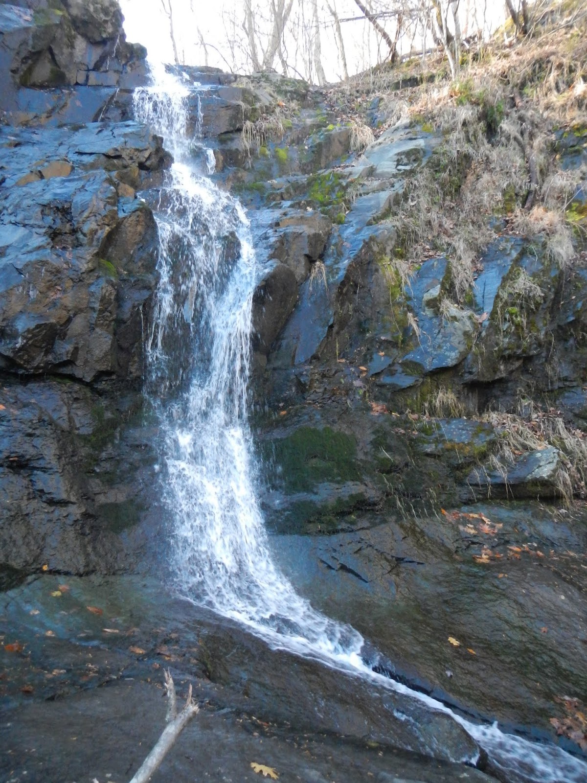
This time of year, you never know whether to expect a trickle at the three falls or not.  I felt as if the flow were unusually strong for late November.  Within a fairly short hike, you are comforted by running water for several miles.  I liked the water sheeting over this rock face:

Doug, Eric, and Charlie Brown stand in front of Big Falls on Jones Run.  The falls are about 40 feet.

Big Falls.

The trail follows Jones Run (left) for some time, and then goes uphill when it reaches the Doyles River.

Lower Doyles River Falls makes me think of a bridal veil.

Upper Doyles River Falls was the perfect lunch spot.

It was a pleasant day hiking, and Charlie Brown's first hike!  Doug adopted him recently as a rescue dog.  He seemed to enjoy the outing, even finding some awful pungent substance to roll around in on the trail back.  It smelled like deer urine or bear urine.  He smelled awful and we drove home with the windows down.  Other than that, it was a fun hike with good company on a nice day in the mountains.

And with that, I've caught up my four recent hikes!  But I hiked yesterday, and thus, am behind again.

Sunday, December 1, 2019

Patterson Ridge and Frazier Discovery Trails

On November 21st, a Thursday, I went on the hike that I'd planned a few days before when we got iced in and hiked Ragged Mountain instead.  I tried to get a group together, but that is tough for a week day with only a few days notice.  In any event, one other person from the trail club told me that he wanted to go, so off we did.  Directly across the Skyline Drive from the Patterson Ridge Trail was the 1.2 mile Frazier Discovery Trail Loop, so we hiked that as well, for a total of about 8 miles or so.

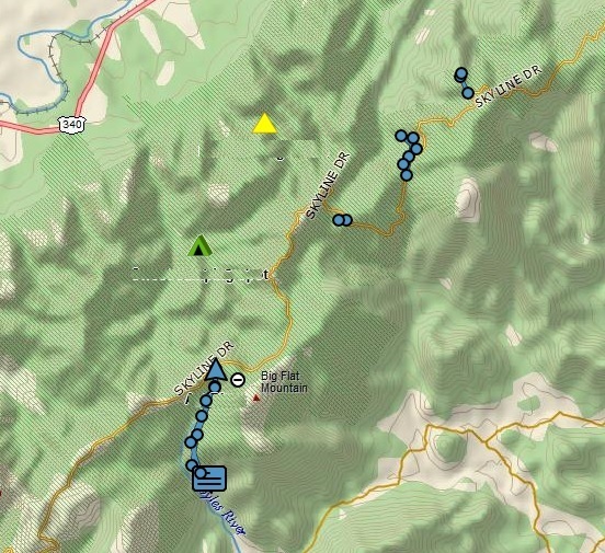
Here is the track of the hikes.  Patterson Ridge is the long out and back heading northwest, and the Frazier Discovery Trail is the small loop to the southeast.  Our cars were parked at the yellow star.  Although one may think of a ridge as fairly level, the trail was actually almost all downhill on the way out uphill on the way back, descending and then ascending more than 1,600 feet.  The Frazier Discovery Trail gained over 400 feet on the way up, so the total elevation gains for the day was about 2,150 feet.

On the way along the Patterson Ridge Trail, we had partial views of Rockytop, where I had gone backpacking less than three weeks before.  It brought back good memories, and I regaled John with some of the tales from the trail, like the fresh bear scat near my tent, the big buck that jumped into the stream, and my stove not working after the first day.

We had lunch at Big Run along the Big Run Portal Trail.  It was such a beautiful spot.

After lunch, we got back on the trail and hiked uphill continually for just over three miles.  I am in much better shape than I was two months ago, and was able to hike without needing to rest every 10 seconds!

Although the Frazier Discovery Trail is short, it had some spectacular scenery once we climbed 450 feet and reached the Appalachian Trail:

See the notch in the middle?  That is the point where Big Run passes west through the mountains on its way to the Shenandoah River.  It is also the meeting point of two of my recent hikes:  Brown Mountain coming from the right and Rockytop Backpacking coming from the left.

This pretty doe finally ran when John came up with me, but until that point, she was cautiously wary buy not scared.

John on the ridge line.

Technically, we are along the Appalachian Trail here for a tenth of a mile or so, the same section that I'd hiked a couple of weeks ago with the Trail Club, heading north to Simmons Gap.

On the way down, we passed by this massive rock face.


What a great day to be in the mountains!  I felt blessed to have the ability to hike well, and on a Thursday to boot!  And now, I have finished every trail in the Big Run watershed of the park.

Saturday, November 30, 2019

When Life Hands You Frozen Lemons, Make Lemon Slushies

A couple of weeks ago, a group of five us headed up to hike the Patterson Ridge Trail in Shenandoah.  We knew that it was going to be cold, starting out near freezing and ending up about 35 F, but no precipitation was called for.  Nor was any showing up on weather radar as we made the nearly two hour drive to the park.  About 5 miles from the park, the temperature was 38 degrees, but it started dropping.  36.  35.  Drizzle. 33.  32. Freezing drizzle.  31, and more.  By the time we got to the park gate, it had dropped 11 degrees in five miles of driving and everything was being coated in ice!  The park closed, along with all 105 miles of the Skyline Drive.  What do do?  We talked it over in the car, and headed to Ragged Mountain near Charlottesville, a place I had never been but had wanted to hike anyway.

The hike was about 7 miles, and temperatures were in the 40's, with no precipitation.  Here is a track of the trail we hiked in this wonderful natural area.  We hiked clockwise, starting and ending at the star.

Here are the five of us near the start of the hike.

This hike didn't offer any grand mountain views, but we did have pretty views of the reservoir and of the fall forest.


This floating bridge was amazing. I don't think that I'd ever crossed one before.

More water and forest views....

A skilled wood carver made these owls a couple of miles in.


The leaves are falling fast, but now and then we saw a little foliage.

More wood carving: an eagle catching a fish,

and a bear with her cub.

We also enjoyed meeting this mountain man, the final carving encountered on this very nice hike:

Well, we didn't have a Plan B when we started driving to the mountains, but among the five of us, we quickly came up with a good alternative once the initial plan was squashed.  It turned out to be a very fun hike with a good group, with no slipping and sliding.