Saturday, March 29, 2014

Hiking in Caledon Natural Area SP

Yesterday, I had the day off from work and planned a hike.  My original plans had been to go for a one night backpacking trip in the rugged Laurel Forks area on the West Virginia border.  But given the snows we have been having lately, especially in the mountains, that seemed ill-advised, so I have put that trip on hold.  Instead, I headed to Caledon Natural Area State Park in Northern Virginia on the Potomac River.  See the red star below for the location:
Caledon Natural Area is mostly mature hardwood forest along the river, which is an important nesting area for bald eagles.  In addition to five bald eagles, I saw a great horned owl, a number of white-tailed deer, osprey, kingfisher, tufted titmice, chickadees, and juncos, among other birds.  Below is the route for my 7.2 mile hike, which was a loop with some out and back portions.  I started and ended at the star, and the red arrows show my travel direction.
Most of the hike was fairly easy, but there is some terrain, and especially the western most portions had a lot of short and steep uphill and downhill.
I am big fan of taking a topo map on my hikes, especially into the more remote areas.  But the state parks do a great job of marking their trails, and the trail maps that they provide was adequate for my travels yesterday.
There are a number of streams flowing through the park, heading to the Potomac River and eventually to the Chesapeake Bay.  Soon after I started hiking, it began to rain steadily, and I put my binoculars away.
The photo below is very typical of the area, with some terrain and large hardwoods, generally 1-2 feet in diameter, with some much larger trees.
A footbridge crosses the swamp at this point, and this is where I saw the great horned owl.  I dug my binoculars out of my pack in the rain to get a better view.  That was a very cool sighting.
This is Caledon Marsh, on the edge of the river.  It was at this point, about three miles into my hike, that the rain stopped, and the sun even came partially out.  It was just in time for ....
... lunch by the Potomac River.  It was here that I saw the eagles and the ospreys, as well as the belted kingfisher.
This was the best photo I could get of a bald eagle.  This one was immature, but I saw several others mature ones with their striking white heads.
Late in the hike, I came upon this large hollowed-out tree.
It was hollow all the way to the bottom, and I imagine that animals sometimes den it it.
You can see that some of the trees area really large.  I leaned my trekking poles up against this one for a look at the scale.
I had a fun day hiking around and exploring the Caledon Natural Area.  It is a fascinating place, and sure beat being at work for the day.

Monday, March 3, 2014

Rockfish Gap to Paul Wolfe Shelter

About a month ago, my hiking buddy Hawkeye suggested a winter hike along the Appalachian Trail from Rockfish Gap south to the first shelter on the trail from that point, the incomparable Paul Wolfe Shelter.  It would be five miles each way in the out and back hike, and we decided to go Sunday, March 2.  Along the way, I asked my friend Doug if he wanted to hike with us.  In the meantime, Hawkeye and I decided to do something a little different for a day hike and cook lunch at the shelter.  Since I am preparing for a short backpacking trip later this month, I wanted to carry some extra weight and brought things I normally wouldn't bring on a day hike, such as my stove, cook kit, and some extra clothing.  I got my total pack weight up to about 25 pounds.  Hawkeye thought that cooking some steak and vegetable packets in the fire would be a great lunch and I agreed, although I made mine heavy on the veggies and light on the steak.

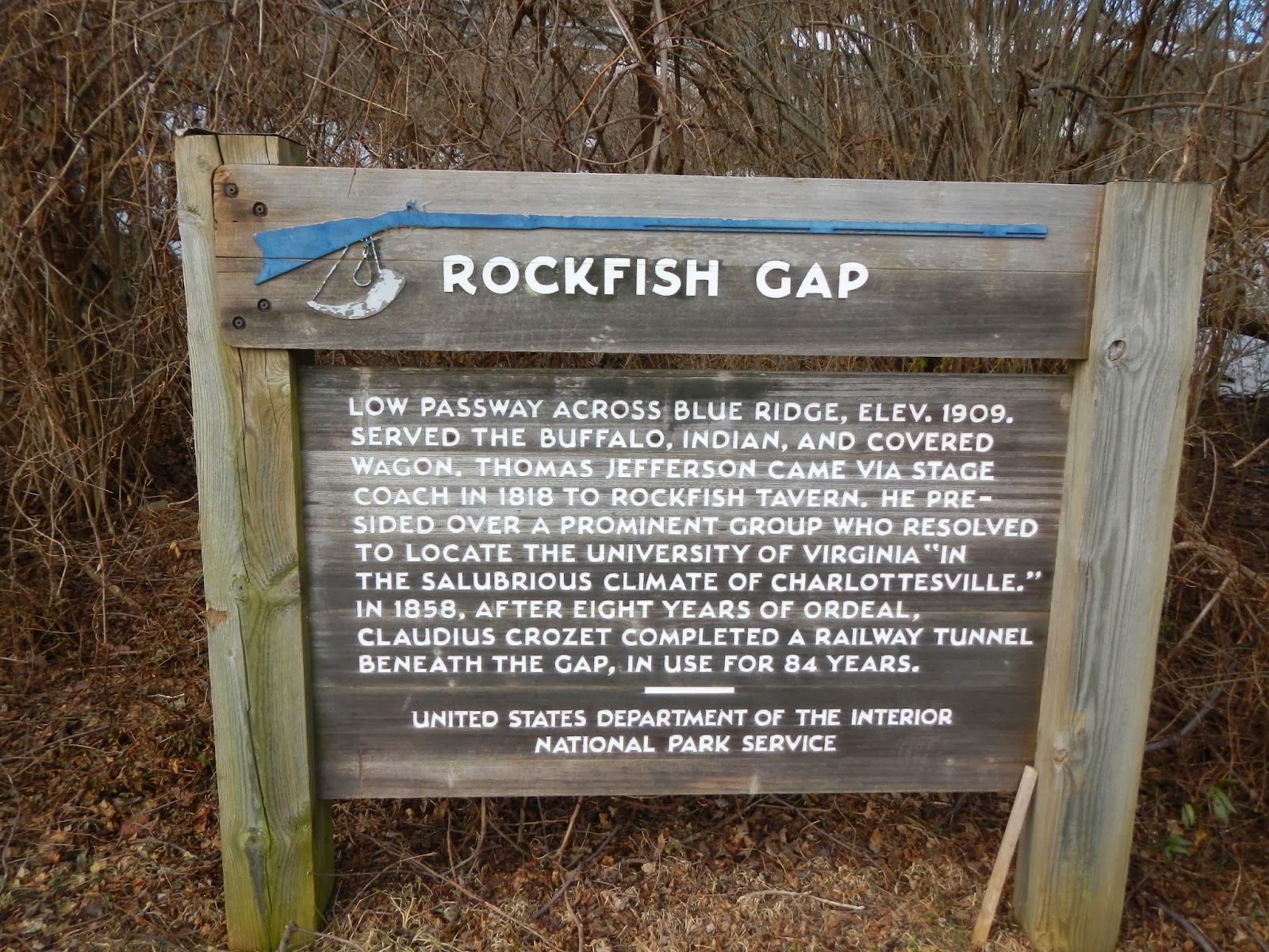
Rockfish Gap is where Interstate 64 crosses the Blue Ridge Mountains.  It is the jumping off point to Shenandoah National Park via the Skyline Drive to the north, and the Blue Ridge Parkway to the south.  It has some history behind it, as the sign below shows.  At one point, this area would have been total wilderness.
The topo map below shows our route along the Appalachian Trail, started and returning to Rockfish Gap at the north (purple circle) and stopping at the Paul Wolfe Shelter to the south for several hours (purple arrow).
You can see that our route, based on the elevation profile, was typical of the Appalachian Mountains, with lots of ups and downs interspersed with some fairly level ridge lines.  The profile below is one way to the shelter.  I didn't record it on the way back, as it would have just been a mirror image of the five miles in.  The total elevation loss and gain for the whole trip would have been about 2,800 feet gained and 2,800 feet lost.  There was more downhill than uphill on the way in.

So we got to the trail head around 9AM and started hiking.  It was chilly at the time, and I started out with three layers, including a fleece.  Within 20 minutes, I stripped the fleece off and continued in a short sleeve wool shirt and a long sleeve wool shirt.  It was not long until I was in just the short sleeve shirt as the morning warmed rapidly.  It felt great!  And even lounging around the shelter, I only needed the one shirt for most of the time.

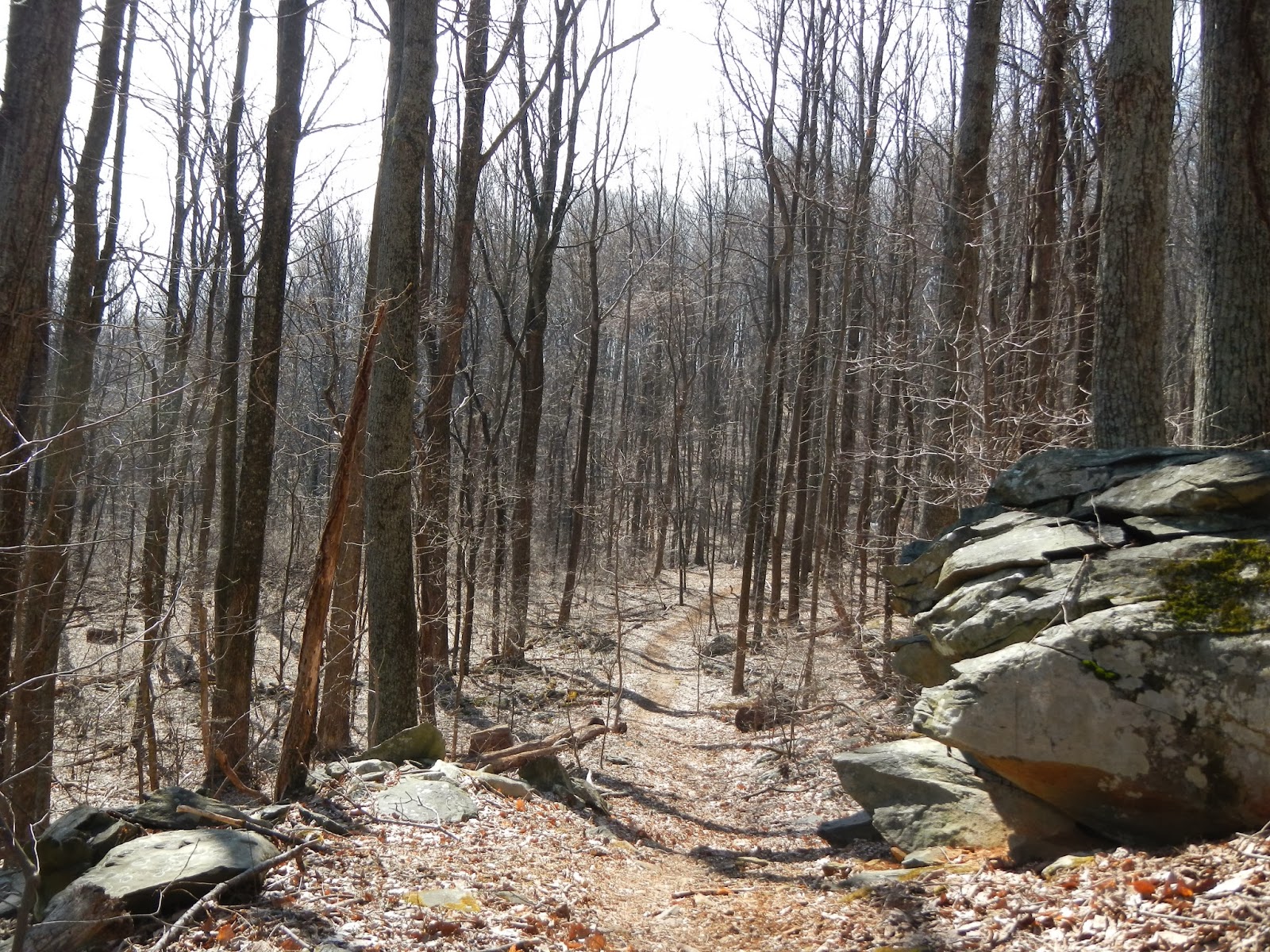
The photo below is typical of the woods we walked through - naked hardwoods.  The trail is very well maintained by the Old Dominion Appalachian Trail Club, which I need to rejoin.
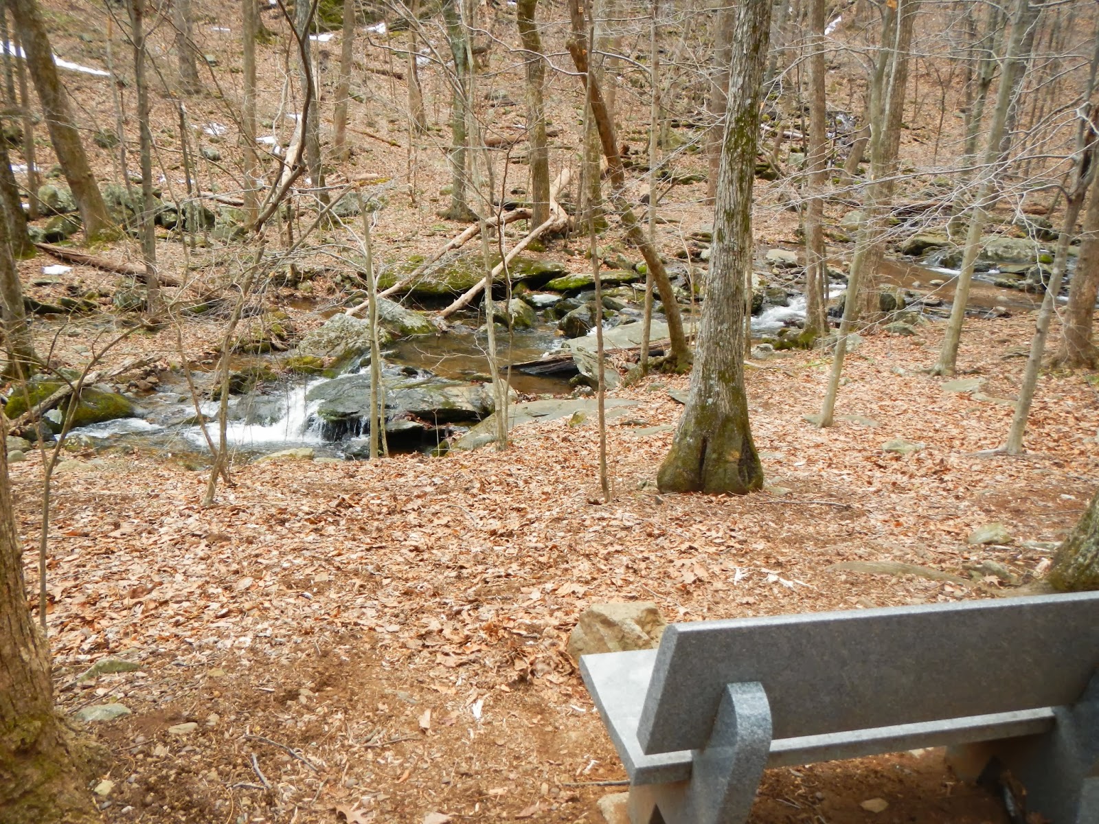
Although there wasn't much snow in the woods, there were patches of ice in the creeks, of which we crossed at least four.
I liked the combination of whitewater and green moss in this small riffle.
Hawkeye and Doug hike along the Appalachian Trail.  Somewhere down in Georgia and North Carolina at this exact time, through-hikers are slowly making their way north.
After five miles of walking, we reached the Paul Wolfe Shelter, the nicest three sided back country shelter I ever remember seeing.  It even has a covered porch.
Our first order of business was to build a fire.  We collected, with relative ease, a lot of dry sticks from fallen branches.  We wanted a small, hot fire.  We collected dry twigs much less than pencil diameter, a bunch of twigs about at thick as a pencil, many finger sized twigs, and ended with small branches maybe 50% again as thick as a finger.  We collected some dry tinder, and got the fire going without a match by using my emergency fire starter flint.  I had never tried it before, and it worked like a charm.  See the smoke and the tiny flame on the right?
In minutes, we had a nice fire going among all the small branch pieces, and took time to explore a lot.  Very close to the shelter is a memorial bench to John Donovan, a long time member of the Old Dominion Appalachian Trail Club, who put this bench in this spot to honor John's memory.
John unfortunately died on the Pacific Crest Trail all alone in 2005, just days after his 60th birthday.  I wrote about it here.
What a lovely spot for this bench, the brook babbling as it flows inexorably towards the Chesapeake Bay hundreds of miles away.
Here is John's memorial bench, with the shelter about 100 or so feet away.
Did you ever camp at a back country shelter with a covered porch and a picnic table on the porch?  Talk about deluxe!  Not too long ago, some idiots built a fire on the porch and ruined it, but the ODATC has since rebuilt it.
The shelter even has "bunk beds" with an upper level for tired hikers!
We relaxed and talked for a while, using my stove to boil water for tea and coffee.  What a luxury on a day hike!  I also made some hot chocolate later.  Hawkeye and I put our meal packets directly on the hot coals and then burnt some leaves and forest junk on top to cover them with hot ashes.  Doug cooked his on the grill.
Here is Doug, about to tuck into his lunch.
And here is my lunch - potato, tomato, red pepper, carrot, and onion (from Hawkeye) with a small piece of steak.  It was delicious, if I do say so.  Hawkeye and I agreed it was the best day hiking lunch either of us could remember!
By around 1:30 it was getting cloudy, and by 2PM, we decided to pack up and leave.  We drowned the campfire and stirred the cold ashes and hit the trail.  At exactly that moment, it started to rain, and the rain increased in intensity for the entire hike out.  The trail turned muddy and sloppy, the rain soaked through my jacket - yeah, definitely time to replace it - and the temperature began to drop.  What had a been a beautiful spring-like sunny day with highs near 70 would, in less than a couple of hours be a steady rain, and about 17 hours after that back in Richmond would be temperatures in the 20's and a steady snowfall.

When we got back to the car, all fairly soaked, I had to admit that I was glad not to be camping out that night.  Instead of crawling with wet skin into a sleeping bag in a tiny tent as the temperature dropped and the snow began, I would be able to get a hot shower and sleep in a warm bed.  But the rain could not lessen the fun we all had on the hike to the Paul Wolfe Shelter!

Thursday, February 13, 2014

Planning a Mini-Adventure

One of my hopes this year is to go backpacking at least three times, and I am starting to plan the first of these, a single night, 14 mile loop in the Laurel Forks area of Virginia.  This is a rugged and remote portion of the George Washington National Forest on the West Virginia border.  The area has some similarities to Canada in the vegetation and even some of the wildlife.  Although it is not a wilderness area, it is not swarming with people either.  From what I have read, I am not likely to see another person on this trip.  There is a trail system that, depending on the account you read, is either fairly well blazed or inadequately blazed.  There is a major stream that will have to be forded twice, and it will be at least knee deep, and maybe even deeper than that in the spring - and bone-chillingly cold!  But the reward will be a great camping spot very close to the stream.  The bad new is that within minutes of breaking camp, I will have to wade across that ice-cold stream for the return hike.  There are no grand views, I think, but lots of beaver ponds, the potential to see wildlife, and some great forest hiking.  It sounds like fun to me!  How about to you?
I am thinking of going in the next five to seven weeks, essentially early spring.  The area is no doubt buried in snow right now, and I want to pick a time when it is not snow covered.  I don't know if that would be late March or early to mid-April.  I've asked a friend if he wants to go but haven't gotten an answer yet.  I am hoping he does, as it would be more fun with another person than going by myself.  But no matter, I am planning on doing this hike either with someone or alone - unless the weather just is horrible or I find a better trip to do.  I will also need to potentially alter my route on the fly if I get to the stream and it is dangerously high from spring runoff.  That would be disappointing, but better disappointed than drowned, eh?

Later in the spring, I am planning a much grander trip that I will discuss later.  So the Laurel Forks hike will be a great starter for my 2014 plans.

Sunday, February 9, 2014

Short Pony Pasture Walk

Friday being a day off for me, I had hoped to go for a nice hike, but stuff around the house interfered.  I did, however, take the time to go for a nice winter walk around the Pony Pasture, a few miles upriver from downtown.  One would never know that there is a large city just a few miles away.  Here are some photos from my walk.

This is a great spot to see buffleheads.  If I could have gotten a better close up, this duck would have been the subject of a "What am I?"
Here is a panoramic view of the James River at the Pony Pasture Rapids.
The trails here are flat and civilized.  It was a typical winter day here, kind of bleak and in the mid-40's F.
I liked this tree.  The bark reminded me of military camouflage.
This is a view of a little backwater leading out to the river.
I loved the shape of this big red cedar!
We have had a lot of rain lately, and there were many sections of the trail that were muddy and wet.
Other than the buffleheads at the start of the walk in the river, I saw very little wildlife on my hour of walking - a couple of gray squirrels, a cardinal or two, a pair of mallards, and a sparrow.  But it was good to get out and stretch my legs on a winter's day, and think about grander hikes to come!

Monday, January 20, 2014

Bright Hope Trail, Pocahontas State Park

Thursday at work, my hiking buddy Hawkeye suggested that a few of us go for a hike Sunday (yesterday).  So we agreed to meet up at 11:00 at Pocahontas State Park, southwest of Richmond.
At the parking lot, there was a guy and his five Samoyed sled dogs getting ready for a wheeled sled ride along the trails.  How those dogs could bark!  They were so excited, and deafening.
Hawkeye selected our route, the Bright Hope Trail, which made for a pleasant and easy 5.4 mile hike.  It was a good first hike of 2014.  We started and ended at the orange star and walked counter-clockwise.
You can see that while there was some uphill and downhill, it was pretty minor with total elevation loss and gain of less than 400 feet.  Plus the trail was nicely graded and smooth, with no roots or rocks to trip over.
This was my first chance to try my new trekking poles.  The photo shows one folded up, with is a big reason that I wanted this pair.  They will easily fold up into a pack or suitcase.  They don't have shock absorbency, but I really liked them.
My hiking comrades, Hawkeye and Larry, pose near the start of our hike through the Piedmont forests of Virginia on a beautiful winter day.
There is an old cemetery along the way, the Gill-Dance Cemetery.  It was sad to see tombstones of so many very young children, many under six months of age.
I laughed when I saw an old man in this tree (with a distorted nose).  I could see an eye and mouth.  It reminded me of the ents in the "Lord of the Rings" movies.
Most of the hike was forest just like this.
At the end of this hike, Hawkeye suggested we do another shorter hike of about 2.5 miles around Beaver Lake, but I foolishly declined.  I wanted to get home to watch the AFC Championship Game, which I thought was going to be a great game and a classic quarterback duel.  I was wrong.  It was a one-sided game and only one of the quarterbacks played great.  I was really annoyed with myself to not go on the second hike.  But anyway, I had fun hiking the Bright Hope Trail on a pretty day.

Friday, January 17, 2014

Ultimate Hiker or Ultimate Camper?

I recently began reading a great book that I bought a few months ago: "The Ultimate Hiker's Gear Guide" by Adventurer (the Capital "A" was intentional, cause this guy is a real Adventurer!) Andrew Skurka.  I mean, this guy has done 30,000 miles of long distance hikes, including the 4,700 mile Alaska - Yukon Expedition!  He once spent 11 months traveling 7,800 miles coast to coast, including 1,400 miles on snowshoes through Michigan, Wisconsin, and Northern Minnesota.  So yeah, Adventurer! I highly recommend this book to any hiker or backpacker.

In the first part of the book, the author discusses backpackers as being either Ultimate Hikers vs. Ultimate Campers.  One of the key characteristics separating these two groups is the type of fun one loves to have in the outdoors.  Type 1 Fun is fun at the time and fun to talk about later.  Type 2 Fun is not really fun at the time, but fun to talk about later.  And then there is Type 3 Fun, which is not fun at the time and not fun to talk about later, although how can that be considered "fun?"  In my mind, type 1 fun might be a back country trip with great weather, great scenery, or great wildlife where you are never too exhausted, wet, cold, or hot.  Type 2 fun might be the same great scenery or wildlife, but maybe the miles are long and exhausting, or your tent fails and you are soaked for days, or a bear eats most of your food with three days to go.  Type 3 fun?  Well, that probably has some element of tragedy, like you lose fingers or toes to frostbite, or someone on the trip dies - not fun in any respect, I should say.

Among other things, the author characterizes Ultimate Hikers as wanting trips dominated more by Type 2 fun, whereas Ultimate Campers are more into Type 1 Fun - fun at the time, and fun to talk about later.  Some other key differences: Ultimate Hikers tend to want tough challenges, they have a long hike with very long (20-30 mile) days as their primary objective, are more knowledgeable about being comfortable and safe in the outdoors, are very gear conscious and scrutinize every item in their pack, and tend to arrive in camp late and leave camp to hit the trail very early.  Ultimate Campers tend to have some other kind of objective as their primary goal - birding, hunting, photography, backcountry cooking - as opposed to just wanting to do a long and arduous walk.  They tend to carry more gear to be prepared for anything that could reasonably happen, have a more relaxed daily itinerary, and don't have as high a skill level because they carry gear and supplies that don't require high skills to use.

I have to say, I am more of an Ultimate Camper, although I would like to acquire more trip knowledge and gear knowledge such as the Ultimate Hikers and ultra-light backpackers have.  But I am definitely more into Type 1 Fun, that is for sure.  Of course, I've had my share of Type 2 Fun at times, and enjoy recalling it.  The time I camped out without a tent and got eaten alive by mosquitos all night while a fox crept up in the dark to sniff my face.  The time I spent hours drying out from a hellacious thunder and hail storm only to fall into a river trying to photograph a moose.  The many times when I packed stupidly and staggered for miles feeling like an abused pack mule, reaching camp too exhausted to do anything but put up a tent and crawl inside.  I could go on, but won't.  So anyhow, yeah, it is mostly Type Fun I am into when I hike and backpack!  However, I am willing to become more of an Ultimate Hiker and do some longer trips, which pretty much ensures at least some Type 2 Fun.  So a trip with a mixture of type 1 and type 2 fun would be all right.

What about you? Where would you fit in this categorization?  Would you be more of an Ultimate Hiker or an Ultimate Camper?

Sunday, January 5, 2014

Trail Miles

My friend Hawkeye and I were chatting the other day about hiking and the new year, and he told me, "I've set a goal for 2014.  I want to hike at least 100 trail miles."

And that got me thinking - in all my hikes, how many actual trail miles do I get in on my feet?  I keep track of my steps, over 5 million of them last year, and that translates to over 2,000 miles on my feet.  But how many of that is actual hiking on trails?  Well, because of this blog, I can go back and see.

So I looked at each blog post, and added the miles for each hike.  I am counting only actual hikes, not miles spent beach combing, for example.  The answer for 2013 is that I took 22 hikes for a total of 90.7 trail miles.  In addition, I took seven "urban hikes" for a total of 35 more miles.

Using Hawkeye as an example, I am going to add a goal for 2014 to hike 20% more miles than I did last year.  I'll round that up to 110 miles in actual hiking on non-urban trails in the current year.  As of today, the actual number of trail miles for the year stands at 0.