Sunday, April 26, 2015

50 Shades of Green

After six weeks of being very sedentary to rest my sore ankle - I gave up wearing the boot because it made my back hurt - I finally lost patience and decided that it was time to take a hike.

I love hiking in the spring - all of the new green, the wildflowers, the birds migrating and   defending their territories with their singing.  I love the Italian word for spring, primavera - "first green."  There have to be at least 50 shades of green in the woods and fields - all fresh and new.

My friend Hawkeye suggested we do an overnight out and back along the Appalachian Trail to the Paul Wolfe shelter, 5.5 miles south of Rockfish Gap.  He didn't have to twist my arm, and we planned on going Saturday and Sunday.  The weather forecast got worse and worse, and then Hawkeye called me about 2PM Friday and suggested we go now!  A quick check with my better half and I was ready to go.  Hawkeye picked me up about 3:15 and we hit the trail by about 5PM.  Immediately, we were greeted by beautiful violets, which we saw over and over.


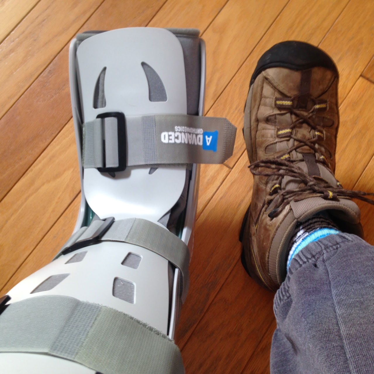
This stretch of the Trail is beautifully maintained by the Old Dominion Appalachian Trail Club.  I loved seeing all of the fresh green, and much of the trail is smooth and level, with some uphill and downhill.  My ankle definitely felt sore, though, and hurt a fair bit after a couple of hours of hiking.

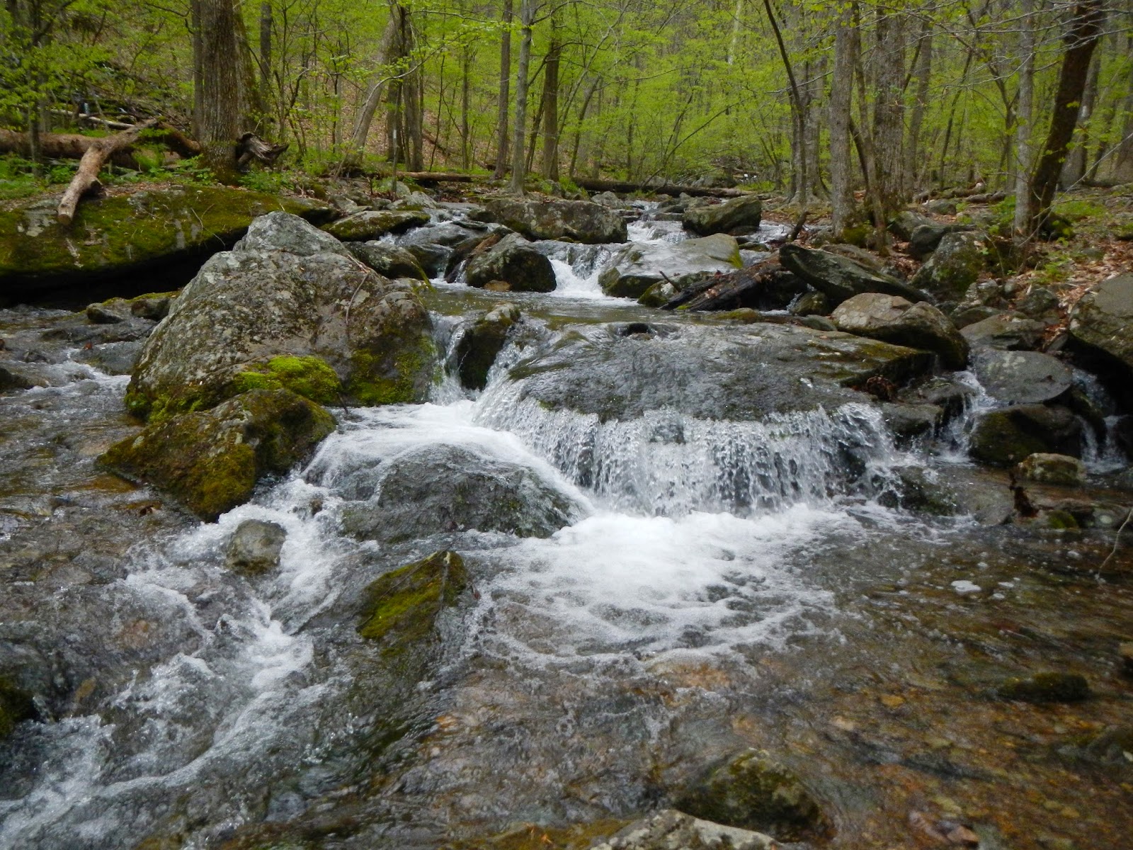
We crossed at least 3-4 beautiful streams on the hike.  I only carried one bottle of water because I knew I could replenish it when needed.

No one lives in the thick woods now, but that was not always the case. At some time in the past, a family likely lived at this spot in a cabin.  It must have been an extremely hard life.  I wonder what happened to them?

A mile or so from the remains of the chimney, we saw an open and level area off the trail and checked it out.  It was an old cemetery. 

Writing on the headstones was barely legible.  It was pretty there but kind of sad to think that people there are likely forgotten.

Now and then, there were gorgeous redbud in bloom in the woods as we hiked along.

About 7:30, with 40 minutes of daylight remaining, we reached the shelter.  You can see it here, behind the memorial bench to ODATC member John Donovan, who died 10 years ago in a storm while attempting to hike the Pacific Crest Trail in California.  I know I carry too much stuff while hiking but John was the other extreme.  If he carried the things I did, he likely would have survived and still be out there hiking, and there would not be a bench here.  It's sad.

The shelter is open on one side, but is comfortable and actually pretty deluxe for a trail shelter.  For one thing, it has a porch and a covered picnic table.  Here is what the sleeping area looks like.  No one was at the shelter when we got there.  There was a couple and a dog camping nearby.


I blew up my air mattress and laid down my sleeping bag on the floor as I heated up a cup of Constant Comment tea.  Hawkeye set up his tent down by the stream.  A little while later, just before dark, another hiker - Josh - arrived and put his bag down in the shelter.


Hawkeye and I ate our dinners (mine was a vegan curry freeze dry that was good but too soupy), chatted with Josh, and then about 9:30 made a fire down by Hawkeye's tent.  Josh started the fire with a spark from his flint and knife - no match needed!  It is always fun to meet other hikers on the trail, and we enjoyed Josh's company.  Eventually, I walked back to the shelter in the dark and went to bed, falling asleep quickly.  But two through-hikers, Turtle Bear and Bird Man, came in past 11 and woke me up, despite being quiet and considerate.  I learned the next day that they had left Springer Mountain March 1 and had hiked 36 miles - the last three hours in the dark - the day they came in to our shelter!  Amazing!

In the morning, it was cloudy at first, and then it sleeted for a time!  I'd had a cold night and actually slept in my jacket for most of the night.  I wish I had packed my heavier bag!  I had not slept well once the others arrived and was tired.  But we were in no rush to leave so I lay in bed for an hour, enjoying the sounds of the stream and the birds, especially the wood thrushes.  Here is the morning view from the shelter down to the stream:


The stream is called Mill Creek and is really beautiful.

Hawkeye and I enjoyed spending some time Saturday morning down by the stream before starting the hike out.  The sleet had stopped for a little while.  I also enjoyed mugs of Irish Breakfast and Earl Grey tea from the porch of the shelter.

Breakfast for me was my last piece of chocolate, some trail mix, and a power bar (that said best eaten by last January - but it was still decent).  And as a treat, Hawkeye and I shared a tiny bottle of Dalwhinnie Scotch that I bought last May in Scotland.  I'd planned on us drinking it on our to-be nine day hike last October, but Hawkeye hurt his knee on the second day.

The wee dram of Scotch hit the spot, and soon enough, we hit the trail for the hike up.  The first two miles was a steady uphill of switchbacks, but not steep, and resting my ankle all night had it feeling less sore.  The rain began steadily about 45 minutes from getting back, and when we were nearly back to the car, two young hikers caught up to us.  They were Little Goat and Yellow Beard, had gotten married last September, and now here they are, nearly 1,000 miles into hiking the AT together!  How cool is that?  And how many marriages would survive the discomfort and close quarters of hiking 2,200 miles together over 5 months?  I have a feeling these two are going to be all right, though.  We gave them a ride to a YMCA in nearby Waynesboro so they could take showers, do laundry, and hit the fast food circuit.

I really enjoyed the hike.  Being sedentary for weeks is not a good way to prepare for a hike, even one like this which is pretty easy.  And my ankle still hurts, and I know I have to see the doctor again about it.  But just for the 20 hours we were on the trail and in the woods, part of it in gorgeous spring weather, it sure felt amazing to be alive.

By the way, in March 2014, I did this hike as a day hike and highly recommend it.  You can see photos from that trip here.

Saturday, March 21, 2015

My Hiking Plans Have Gotten the Boot!

Ah, spring is in the air! Time to lace up those boots and hit the trails, eh?  Well, the best laid plans...

Because, for me, the boot on the left is what I will be wearing for a while, not the boot on the right.

I've had ankle pain for over two months, not agonizing, but pain all the same. I've tried cutting back on walking, doing short 2-3 mile walks only. I've not been hiking. But the pain continued, and I saw an orthopedic doctor a week ago. He thinks I have some kind of tendonitis (or tendonosis) in either my peroneus longus or peroneus brevis tendons, or in both of them. These tendons come off the calf muscles on the outside of one's ankle and attach to the bones of the side of the foot and underneath the foot. And on my left ankle, they are quite sore, with noticeable swelling.

It is frustrating for sure, as active as I like to be and with places to hike and things to see. I had two big hikes planned for April - leading a group hike up Cold Mountain and then going on a three day group backpacking trip in Burkes Garden. But not this April as it turns out. Six weeks in the boot. No walking, no hiking. Stationary bike (the one workout that I dislike more than treadmills) is OK. Hopefully things like squats, leg presses, and lunges will be OK. Elliptical machines may be OK, but maybe not. If it causes pain - not! I can continue upper body workouts, which is good, since I also have a painful partial rotator cuff tear as a result of a nasty fall while hiking last September. I'll tell you, start getting a little old, and things just start falling apart! I'd been contemplating doing Team in Training again, but am really glad I didn't because I would be raising money but not following through with my commitment.

So yeah, frustrating, and awkward to walk at all in the boot. But not the worst thing in the world, or even the worst 500, I would say. I will just need to be patient. Hopefully once the boot comes off - April 24, the day I was supposed to leave for Burkes Garden - I can start trying some short walks and then hikes, and see how it feels. If the pain is gone (and if I don't immediately overdo it in my eagerness to move again), then that will be great, and I can start resuming normal activities - sans the boot. By the way, the boot does not need to be worn all the time: not at night at all, or if I am sitting around watching TV or reading - two things I will probably do more of now. I also found that walking very slowly (in shoes) minimizes the pain.

What is it with my left leg? It is always my left side - a neuroma that took surgery to get past it, plantar fasciitis, knee pain, and now this. I actually wrote a tongue-in-cheek piece about the conflict between the left and right sides of my body (like our Congress) when I was dealing with the knee pain before the Shamrock Half Marathon in 2012:

http://racn4acure.blogspot.com/2012/02/body-politic.html

After a week, it's not going so great.  The boot is heavy and awkward, and puts one's entire body out of balance.  As a result, I have wrenched the muscles of my back on the left side a few days ago, and am taking time off from the boot until my back feels better.  I hate being sedentary!

Saturday, February 28, 2015

Orienteering in the Snow

I really had three choices for hiking today - well, four if you include not going anywhere as one choice.  One would be to pick a hike on my own, two would be to join the ODATC on an 8 miler in Lake Anna State Park, and three would be to go orienteering at Fork Union Military Academy (FUMA).  My Meet-up Group had organized our participation at the orienteering competition.  Because I have wanted to try orienteering again, that is what I decided to do.  There were two others going from my group, but I didn't run into them.  So it was like taking a hike by myself after all, just with specific goals.

What is orienteering?  Well, you find your way with a map and, if needed, a magnetic compass.  Leave the GPS behind, which would be cheating.  The FUMA Orienteering Club had four courses, and I choose the second easiest, being pretty new to it.  Maybe I should have stepped up and tried for a harder one.  This didn't seem as difficult as the first time I did orienteering in 2013.  The goal is to locate a number of points, each marked by a numbered flag with a paper punch.  You punch your sheet of paper - there is a distinctive pattern for each punch - to prove that you actually found the objective - and you are timed.  So it can be looked on as a competition if one wishes.  In my case, I just wanted to enjoy a walk in the woods and fields, and locate all of my flags, of which there were 12.

The topographic map is pretty detailed, with each flag location marked with a number and a circle, the course essentially following a circuit hike of a couple of miles.  The distance turned out to be 2.9 miles in my case, including some detours and a bit of wandering trying to find a few of the flags.

Here is a close up showing where flags #1 and #2 on the course that I did were located, and also #12 at the end:

Does this look like Virginia to you?  Not to me!  The snow cover was pretty much uniform, and was just a few inches deep, having compressed considerably over the last few days.  Temperatures were in the low or mid-twenties during my walk, and have rarely been above 25-35 for the past 12 days.

This was one of the prettiest spots during the entire orienteering course, with a lovely little stream flowing along.

Here is an example of a marker, each of which has a number that you compare with the list on the back of your map to make sure that you are at the right one - since it is easy to get confused, and there are four different levels of course to cover.  Note the hole punch hanging under the bag.  This flag was in the middle of soggy little wetland.

This is actually a small lake, totally frozen over.  We don't see a lot of this down this way, but when temperatures stay below freezing most of a time for a while, the laws of physics are going to be obeyed.

I enjoyed being outside in the fresh air today, and working on something challenging.  As it turned out, I only needed to use my compass a couple of times, because the map was so detailed.  I don't know if the snow made this easier or more difficult.  It made walking harder, but at the same time, there were lots of tracks that sometimes gave directional clues.  In any event, it was a fun and somewhat challenging way to start the 2015 hiking season out.  My goal is to hike 200 miles this year, so I still have 197.1 to go!

Friday, February 13, 2015

My 2015 Hiking Goals

Here we are, a month and a half into the new year, and I have yet to take a hike. I was planning for a little hike today, a day off from work, but our cat just had some surgery, so I decided to stay home with her for the most part.

Here are my hiking goals for this year.  I have a couple challenges going on right now - a moderately sore left ankle that I cannot figure out, and partial tearing to my rotator cuff.  The latter has been a problem for 8 years, but was made a lot worse in late September when I took a very hard fall while hiking in West Virginia.  I probably should have had surgery, but am trying a lot of exercising to strengthen the shoulder and stabilize the joint.  That won't heal the torn tendons, but maybe I can make it for a while longer.  The ankle is just a mystery - it started suddenly but not after any traumatic event that I can remember. 

My goals:
  1. Hit the trails for 200 miles.
  2. Go backpacking at least three times.
  3. Join my friend Dick for his annual hike - at age 90 this year - up Mount Washington in New Hampshire.  This will be scheduled at the last minute by Dick, and I will join him if at all possible.  There is thought that Dick may be the first nonogenarian to summit Mount Washington, the highest mountain east of the Mississippi and north of North Carolina.
  4. Take a week-long hiking vacation - I have scheduled one in Oregon for this coming summer, a state that I have never been to.
  5. Lead at least two group hikes.
  6. Master my (fairly) new DeLorme Inreach Explorer.  This one will be a little difficult to measure, but it has a lot of capabilities that I don't know how to use yet.
  7. Take hikes in at least five of Virginia's wonderful state parks.
This seems like a pretty good list to me, with some challenges.  Among the backpacking trips, I would love to see if I can get into Ramsey's Draft Wilderness, McAfee Knob, and/or False Cape State Park.


Thursday, January 1, 2015

How Did I Do With My 2014 Hiking Goals?

Happy New Year!

At the start of the year, I set some hiking goals for myself for 2014.  How did I do?

Hike 8 new places this year - I did 13 new hikes last year!  That goal is reached.

Hike 5 times in Shenandoah National Park or the area.  I did 8 hikes in SNP or in the Blue Ridge.  That goal is reached,

Hike in two states not hiked in during 2013, and one of these must be a state I have never hiked in.  I hiked in West Virginia in April and again in September, a state I never have hiked in before.  But I never got to a second state, at least the way I measure it.  To qualify as a hike for this purpose, the trek must be at least four miles long.  I did three short hikes in Maine and they totaled more than four miles, but no single hike was that long.  So, I will count that as partially attaining that goal.  I took hikes in Virginia, Michigan, West Virginia, Maine, and New Jersey.  I think that is it.  The Maine and New Jersey hikes were too short to qualify towards this goal.

Hike in a foreign country.  I went hiking in Scotland in May.  That goal is reached.

Volunteer to lead a hike.  Nope, not last year.

Go backpacking three times.  I did four trips, a one-nighter by myself in Laurel Forks, a three nighter in the Cranberry Wilderness of West Virginia, two nights solo around Matthew's Arm, and two nights (should have been eight nights) on the Appalachian Trail.  So, that goal is reached.

Practice navigation (without a GPS) and orienteering.  No progress on this goal.

Hike at least 110 trail miles.  I hiked 195 non-urban trail miles, so that goal is reached.

Keep this blog going.  Yup, doing that, clearly.  I've documented every hike I have taken since mid-2008 on this blog.

So, all in all, I attained most of my goals but failed completely on two goals, and only partially attained one more.  I think I am especially happy with how many times I got out backpacking and the number of trail miles I did.  One thing that is clear - I get out a lot more for hiking when I am not training for a half marathon or other long race.

Monday, December 29, 2014

Two Short Hikes in Mid-Coastal Maine

I realized that I never posted accounts of two short hikes that I took back in early October when I was in Maine.  Near the end of our trip to the Pine Tree State, we went to one of our favorite state parks, Wolf Neck Woods, and the next day, I took a little hike at the Maine Audubon Society's Mast Landing Preserve.

Wolf Neck Woods State Park is in Freeport, and is located at the black star:

We hiked the Casco Bay Trail along the bay, a short out and back.

The trail itself is mostly wooded.  This park was a favorite of ours when we lived in Maine long ago.

The Maine Coast is pretty spectacular.  The island is Goggins Island, and a pair of ospreys have nested on it for as long as I can remember.


On our last day in Maine, my wife wanted to return to LL Bean and some other stores, so I took a short hike while she was shopping.  I went to Mast Landing Nature Preserve, located here at the black star.

I hiked a short circuit of a couple of miles, hiking through heavy woods.

These photos are typical of the forests at Mast Landing.  I didn't see any wildlife other than a squirrel and a few small birds.  But I enjoyed one last little trek in Maine before heading to Boston later that day.


Saturday, December 27, 2014

Powhatan State Park Trails

I've not had time to hike in over a month - just too much going on.  So when I had a last minute chance to go today, even though it was solo, I jumped at the chance.  You could not have asked for a nicer winter day.  I was hiking without a jacket most of the 7.6 miles.

For my hike, I chose Powhatan State Park, about a 30 mile drive from my house.  It is a new addition to Virginia's great state park system, and I had never been.  I really enjoyed it.  While not spectacular, the trails are broad, easy to follow, and mostly level.  I saw at least 20 other walkers, many of them with dogs or children.

Here is a map of my track.  I started and ended at the red circle, and I went more or less counter-clockwise, in the direction of the orange arrows.  The red arrow shows the direction of the James River as it heads inexorably to the Chesapeake Bay.


I hiked on at least four different trails to cobble together my route.  My first trail was the cabin trail, and it featured the bones of a long-gone cabin.  I wonder what the family that lived here experienced?  If you look at the map above, there are two little blue rectangles on the right hand side.  This cabin is located at the more southerly one.

This shows the trail marker for the well-named Pine Trail, the second part of my hike.

Most of the hiking was in a forest, but a mile or so covered some very open country.

I didn't see much wildlife, but most of what I saw occurred right here.  I saw several dozen small birds flitting around in the undergrowth.

I think this is a red-backed salamander.

This part of the trail is heading towards the river.

The James River is wide and deceptively powerful at this point.

I enjoyed getting out for one final hike in 2014, especially on such a gorgeous day.  This hike put my trail miles for the year for about 195, more than 100 higher than last year.

Saturday, November 22, 2014

Cold Harbor Battlefield

Yesterday, I took a four mile hike around the Cold Harbor Battlefield.  Like several other places in Virginia, two major Civil War battles were fought here: Gaines Mill as part of the Seven Days Battle in 1862 and Cold Harbor in June 1864.  They represent Robert E. Lee's first and last major victories.  However, the Battle of Gaines Mill was a single major battle in McClellan's seven day long campaign, most of those individual battles being Confederate losses, but Lee won strategically when the Army of the Potomac retreated.  At Cold Harbor, the battle was an overwhelming Confederate victory, but Lee lost strategically when Grant swung around the Army of Northern Virginia and headed for the 10 month long siege at Petersburg that effectively would end the war.

I used my DeLorme inReach to capture my track.  The red arrows show my hiking directions, part of the walk being an "out and back."  You can see that a lot of the ground is heavily wooded, but in June 1864, most of it was open ground that led to wholesale slaughter as large armies clashed across seven miles of battle fortifications.  The battle lasted from June 1 through June 12, but the worst fighting happened on June 3.  After that, the action was nine days of miserable trench warfare in the broiling June sun.


The walk is easy - especially compared with the difficult times that the two armies had.  It goes past lots of incredibly well-preserved trenches and other earthworks that are now more than 150 years old.  It is sobering to walk in this peaceful place now and imagine what it must have been like.  Some of the Union dead, including many unknown soldiers, are buried at the Cold Harbor National Cemetery.  There were 13,000 Union and 5,000 Confederate casualties here.

The guns are silent here now - I call that a good thing!

The Garthright House was used as a field hospital as artillery shells crashed around.  The lady of the house cowered in terror in the cellar as blood from the injured men above seeped between the floorboards.

Here is one example of 150 year old trenches.  In 1862, the armies here clashed in charges across the battleground.  But two years later, one army (the Confederates) dug in as the other charged them.  This was the precursor to the awful trench warfare of World War I.

Since I was last here, they added some more trails and one of them goes past this pretty new battlefield monument, dedicated to the 2nd Connecticut Volunteer Heavy Artillery, which suffered pretty horrific losses in the state.  It is a nice thing to remember those who made such sacrifices so long ago.

Believe it or not, most of this small pond was coated in ice!  That is really rare for Richmond in November.

These trench lines would have been totally in open land at the time of the fight, but now, a park-like forest grows around them.

This steam is named Bloody Run.  It is clear and refreshing looking now, but 150 years ago, it likely ran red with blood.  Something like 7,000 Union men fell in about 30 minutes on June 3, 1864.  One placard talked about a description of a regiment melting away like a snowfall in the summer. 

I enjoyed having the time to take a little hike on a cold Friday, and to reflect on the long-ago sacrifice by so many Americans.