
Maybe it was the invigorating dip in the deep pool that convinced me. Perhaps it was the timber rattler that I nearly stepped on because I was more fascinated with my brand new GPS than where I put my feet. Or it could’ve been the steep hike back out up Wildcat Ridge, quads definitely taking notice. Or was it the black bears I’ve seen there on several trips, or the water snake catching a trout last year? For all of these reasons, the 9.6 mile circuit hike from the Wildcat Ridge Parking Lot in Shenandoah National Park down into Riprap Hollow is one of my favorite all time hikes.
I have a sentimental reason for loving this hike. In July of 2003, it was my first real hike after surviving lymphoma and being pretty sick for a good long while. Seven months after finishing chemo, and still not up to full strength, it was the hike I choose to make a statement that I could do this again. And every summer since, I always go on this hike.
And so yesterday, for my August challenge, I choose to return to this hike after an absence of more than a year. It was a beautiful summer day up in the Blue Ridge Mountains of Shenandoah National Park, and I was on the trail by 8:45. I didn’t see any bears on this hike, and haven’t seen any for several years here. I did see four wild turkeys and three deer right along the side of the Skyline Drive on the way up. And on the hike itself, I saw two small toads, a little water snake that swam between my feet, three red tailed hawks soaring above, and all kinds of mushrooms. The forest was fairly quiet but I did hear oven birds, eastern wood peewees, and two pileated woodpeckers.
One loses and gains about 2,200 feet of elevation on the circuit, and it goes through rugged terrain. You will know that you have lungs and quads, especially on the hike back up out of the hollow from about 1,800 to 3,000 feet. Referring to the map, the trip began and ended at the red circle, and went counter-clockwise along the Appalachian Trail to the Riprap Hollow Trail, and finally back up the Wildcat Ridge Trail. The green arrow is the location of the pool along the stream down in the hollow.
Later in the week, I may write more about the hike, but for now, will just post pictures. I also wrote yesterday here, a bit tongue in cheek, about doing a triathlon on this hike.
 View down into Riprap Hollow's rugged terrain from an overlook on the Skyline Drive
 Junction near start (and end) of hike of Appalachian Trail and Wildcat Ridge Trail (coming in on the left). You can go either way but I started out by heading down the AT.
 White blazed mark the AT from Springer Mountain in Georgia to Mt. Katahdin in Maine.
 The wood sprite on my hiking staff takes a break while proudly displaying his Shenandoah National Park medal. My good friend Tom, who accompanied me on my Tumbledown Mountain "Kicking Cancer's Butt" hike six years ago, made the hiking stick for me.
 View from Cavalry Rocks along the Riprap Hollow Trail
 View to the mountains north of the Riprap Hollow Trail
 Glad I don't have to tear logs apart for my lunch like this bear did
 The Riprap Hollow Trail bottoms out along a stream sandwiched between very steep slopes to the east and west. It is a beautiful and tranquil valley.
 I can never resist jumping into this deep pool, no matter how shocking the water initially feels on my hot skin.
 A few spots on the steep hike out up the Wildcat Ridge Trail have nice views to the south, but mostly you are in deep woods.
 Finally! A definitive answer to the question that has confounded mankind for milennia: does a wild bear leave his scat in the woods?
 A rare and welcome level spot along the Wildcat Ridge Trail
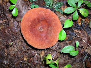
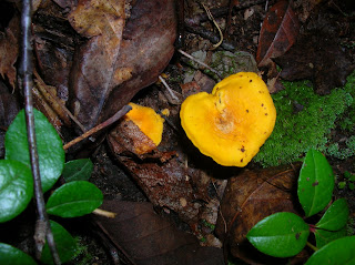
 I saw many cool mushrooms on my hike. I can't identify them, but the variety and colors are the most I've seen since my Bald Mountain hike just over a year ago up in New Hampshire.


 The Hillsman House was used as a Union hospital. Blood stains are still visible in the wood floors, and the family never returned to the house after the battle. Inside, it is made up to look like a field hospital of the time.


 Map of the trail system and historic features.
 The hike started along one of the roads that most people see the park by way of. I only encountered two other hikers in the six miles.
 Monument to Upton's soldiers, who charged a Confederate position after slealthily approaching along a still existing woods road.
 Attractive monument to South Carolina's soldiers at the battle.
 At the "Bloody Angle", men fought at point blank range and hand to hand for 22 hours non-stop. The musket fire was so intense that it cut down a 22 inch thick oak, the stump of which is in the Museum of American History in Washington, DC.
 Monument to New York or New Jersey at the "Bloody Angle".
 Union forces led by Hancock charged the "Bloody Angle" from this now pacific terrain.
 All that remains of the Landram House are two chimney foundations. The house did survive the battle with heavy damage, but the families profitable and productive farm was left in ruins by the fighting. When the family returned, they found 28 Union soldiers buried in their front yard. Another nearby farm had 1,492 Union soldiers buried in its fields, as well as an unknown number of Confederates.
 A cannon silently guards the approach to the "East Angle".
 The trail runs behind Confederate earthworks at the "East Angle".


 This pastoral scene was near the Harrison House ruins, location of one of Robert E. Lee's camps.
 Confederate trenchworks at Lee's Last Line, a nearly impregnable defense designed by military engineer General Martin Smith.
 The original logs used to fortify trenches have long since rotted away, but this small section has been reconstructed so that people can see what it would have looked like.
 This monument to beloved Union General "Uncle John" Sedgwick, who was killed by a sniper early in the battle. Note the tree line in the distance - this is where the bullet that killed him came from. His men begged him to take cover, but his last words were "They couldn't hit an elephant from that distance."


