A few days ago, I closed out - at least for now - my
Racing for a Cure blog with a post about my
top 12 memories while racing for a cure. As I said there, why just 12? Well, because this past April marked my 12 year survival anniversary since discovering that I had Hodgkin's lymphoma. If you learn you have cancer, it is best to think of yourself as a cancer survivor from day one, and that is what I did. And I have been fortunate enough to have 12 more pretty amazing years, for the most part. These mostly happy years have been sprinkled and sometimes liberally dosed with times of sadness and grief, but that is life. I am grateful to still be here, and healthy and strong. And still hiking!
So I thought it would be fun - and challenging - to come up my top 12 hiking memories as well. With all of the hiking I have done since 2002, this was a tall order, and I had to make many cuts at the last moment to restrict things to 12, among them some hikes in the Everglades, Yellowstone, and Mount Rainier National Parks. Here, in reverse order, are my top 12 hiking memories as a cancer survivor.
12. My Last Hike Before Beginning Chemo.
When? June 2, 2002
Where? Shenandoah National Park
Why is it memorable? Because this was the day before I started chemotherapy, it was a gorgeous day, I knew I would not be hiking any time soon, and I felt quite alive and grateful to be up in the mountains.
I'd had surgery a few days before to get a portocath put in, and I was still sore from that, but I wanted to have one last hike before beginning chemo. So we drove to Shenandoah National Park on a picture-perfect day, and drove along Skyline Drive. The hike was short - about a mile total to the Black Rocks. I didn't get a lot of photos on my chemical film camera - how much things change in a decade! - but you can go to
this post from a backpacking trip nine years later to see the area. Or you can go here for more details on my
return to the Black Rocks nine years later.
The mountain laurel was in bloom that day, as seen in this scanned photo from that outing.
I felt really wistful when we left the park that afternoon. I felt like I would survive cancer, but no one really knows how things like this will turn out. Would I ever see the mountains again? Would I ever hike again?
The answer was a resounding
"YES!" Here are 11 more great hiking memories since that June day.
11. Mount Judah.
When? July, 2013
Where? Sierra Nevada area, California
Why is it memorable? Because I made the hike with family - both of my brothers and a sister-in-law - during a trip to celebrate my surviving sister Clare's 70th birthday and to have a family reunion. Plus, the scenery was killer, and I got to hike a bit on the fabled Pacific Crest Trail.
It was a gorgeous day, and we started out early. This was not a long hike, just about six miles, but it was long enough and pretty much a 9 out of 10 for scenery. Plus, it was great to do this with family members who live far apart and can never easily get together. Here is a representative photo, and if you want to see more, just go to my
Mount Judah post.
10. Backpacking to The Priest.
When? November, 2010
Where? Blue Ridge Mountains, Virginia
Why is it memorable? It was my first backpacking trip in nearly 20 years, and even though the weather should have been crisp but not bitter in early November, the mercury dropped to about 12-15 degrees - my coldest night every sleeping in the great outdoors. Plus, I have never seen such amazing stars as on that cold, crystal clear night.
Sure, I'd done lots of day hiking, but I'd not backpacked in a long, long time. When a friend suggested we hike the Priest together - taking in Spy Rock and Crabtree Falls along the way, it sounded like a great idea. And despite the cold weather, at least 15-20 degrees below average, it was a great idea and a great trip. It got me back out to backpacking again.
Here's a photo from the top of The Priest. If you want to read more, start with my account of this great trip
by going here.
9. Hike up to the Kennecott Bonanza Mine.
When? September, 2010
Where? Wrangell - St. Elias National Park, Alaska
Why is it memorable? It was as remote a spot as I ever hiked to, it was amazingly steep, and despite the lack of views because of rain and fog, I did see willow ptarmigan up close, which was quite cool. Plus, it was in Alaska!
We were staying at the
Kennecott Glacier Lodge in the park, an amazing place in itself, and I did a nine mile day hike 3,800 feet up to the abandoned mine site. The views would have been amazing without the rain and fog, the guide kept reminding me. Here are a couple of photos, but for more about the hike,
you can go here. Or to learn more about the
ptarmigans, go here. To learn about the historic
Kennecott ruins, go here.
8. Bald Mountain Nature Preserve.
When? August, 2008
Where? near Antrim, New Hampshire
Why is it memorable? It was simply a beautiful place, I heard loons call again, and there was both lakeside hiking and mountain views, plus I saw the most amazing mushrooms! And I hiked it with my brother and sister-in-law, on her birthday.
This was just a perfect day in the outdoors with family in a beautiful spot. If you have ever heard the call of a loon, you know that this in itself is amazing and memorable. You can r
ead more about this hike here, just weeks into the start of this blog. Here is a photo from the day.
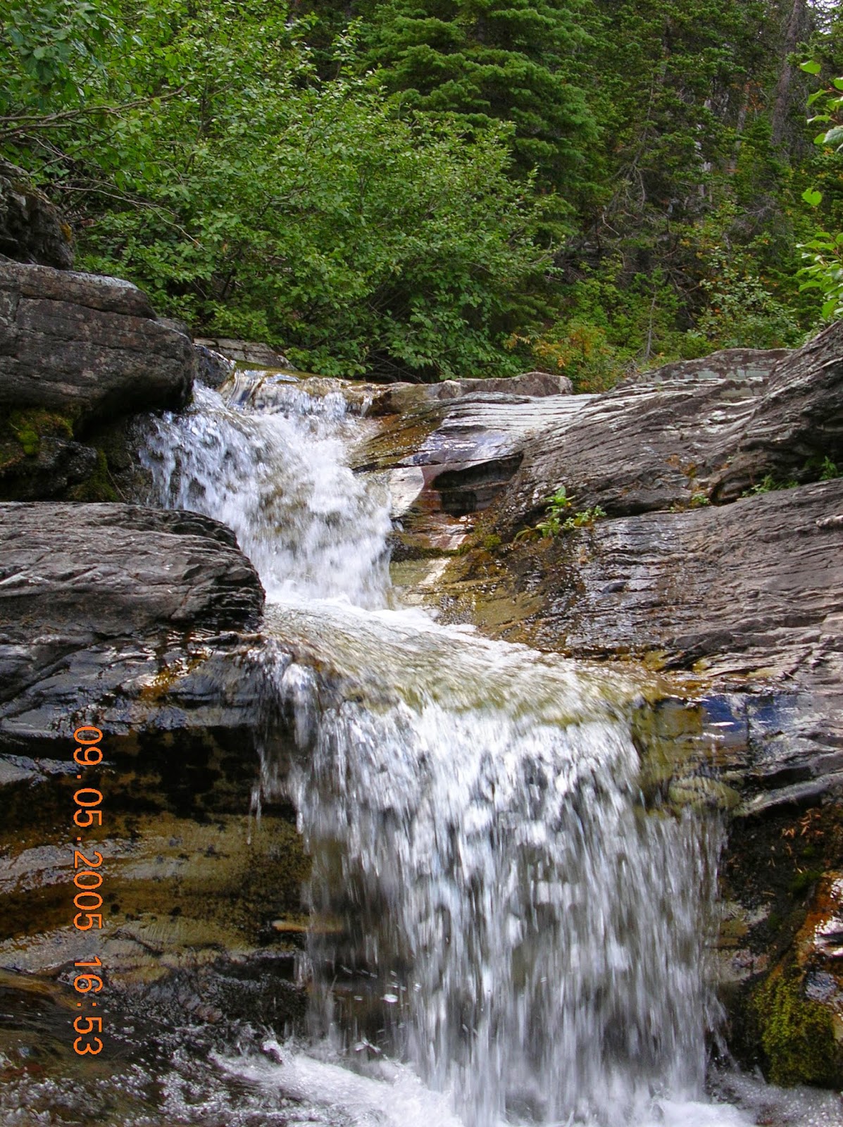
7. Logan Pass.
When? September, 2005
Where? Glacier National park, Montana
Why is it memorable? Here I was, hiking on a trip to see some of the trips of the western national parks, a trip that we had to cancel in 2002 because of my cancer treatments. So I felt blessed to be alive to have a second chance at this trip. It was so beautiful, and we saw several mountain goats up close after seeing them from a distance for several days.
You could spend all summer just hiking in this National Park, but you would be hard pressed to find a more lovely or easier trail. The scenery is amazing, as is the wildlife. Here are a few photos from that hike.
Bearhat Mountain
Alpine views at the turnaround point in Logan Pass
It was pretty cool to have a mountain goat walk past us just 30-40 feet away.
Mother and child - a nanny mountain goat (left) and her kid (right) graze just above the trail.
6. Bullhead Lake and Ptarmigan Falls Hikes.
When? September, 2005
Where? Glacier National park, Montana
Why is it memorable? This was a pair of two hikes on the same day starting and ending at the same place - a five miler to Bullhead Lake and a seven miler to Ptarmigan Falls. Both were out and back hikes. They were memorable not just because of the scenery in a spectacular park, but because we were hiking in grizzly territory, and that makes one feel really alive! Plus, I saw the biggest moose that I have ever seen - at least at that point in my life - on the second hike of the day. When I heard a branch snap, I froze, thinking it was a grizzly! Yeah, memorable!
On the hike to Bullhead Lake, we were in prime grizzly territory and on full alert. A man and his daughter had been attacked and badly hurt by a grizzly just a couple of weeks before a few miles from where we were. And a man we met on a short morning hike that day before starting out on this hike later told us how he had done this hike the day before and had been "mock charged" by a large grizzly three times! We kept making noise as we hiked along, but saw nary a bear. Here are couple of photos from that hike.
I was solo for the afternoon hike to Ptarmigan Falls, a steady but not steep climb along the side of mountain through a large valley. I remember it being beautiful, and I especially remember the moose and feeling certain it was a grizzly. I just knew for sure that it was a large animal, because when the branch snapped, it sounded like a rifle shot! Here are a few photos from that hike.
5. Backpacking on Shackleford Banks.
When? June, 2013
Where? Cape Lookout National Seashore, North Carolina
Why is it memorable? Not since 1973 have I backpacked on a barrier beach, sleeping among the dunes and carrying drinking water. I went with two friends, and we each carried about 25-28 pounds of water for our two night trip to Shackleford Banks. We enjoyed the beach, found great shelling, and enjoying seeing wild horses. I strongly recommend this as a destination if you are up for it.
There is something about being on a remote island. We saw people every day but I don't think a single other person was camping out that weekend. The horses were a special treat. I would love to go back here in the fall when it is cooler. The seashells that we found were amazing! You can go
to this post to read more about my three day trip to Shackleford Banks.
4. Mount Washington.
When? July, 2007
Where? White Mountains, New Hampshire
Why is it memorable? Forty years before, as kids, my father took my younger brother and I up into the Whites, and we hiked to the top of Mount Washington, the highest mountain in the northeastern USA. Now, my brother and I were coming back there together, and it just felt special. I've always wanted to stay in the AMC huts and eat the amazing meals cooked by the "Cru," and that also is very memorable. Plus, my friend Dick, something like 82 at the time, accompanied us, and it was great to hike for three days with him as well. (
read more about Dick here). And as the frosting on the cake, my brother and I hiked to the top of Mount Monroe the second evening and witnessed one of the best sunsets I've ever seen.
The scenery was fabulous, the weather in the somewhat fickle and sometimes deadly Whites was great, the company was a lot of fun, and the meals were delicious. Plus, we were backpacking, but with light packs, as we did not have to carry tents, sleeping bags, cookware, or much food. I plan to go back, and have belonged to the Appalachian Mountain Club ever since. Here are a few photos.
Day 1 - Mount Eisenhower (left) and a distant Mount Washington (center)
Day 2 - final approach towards Mount Washington's summit.
Day 2 - from Mount Monroe summit looking back from where we had hiked that day.
Day 3 - My brother and I on the steep hike out
3. Grayson Highlands Backpacking.
When? October, 2012
Where? The high country of Southwest Virginia
Why is it memorable? This may have been the most fun backpacking trip I've ever done. We were out four days and three nights, and the weather was really nice - no rain, and not nearly as cold as the prior two trips I had done. The scenery was spectacular through much of the hike, and although we didn't see wildlife, and one camping area was crowded and loud, our last night on the trail was at a perfect campsite. As a bonus, I hiked to Mount Rogers, Virginia's highest point.
I wrote a lot of accounts of this trip so I won't repeat much here. Suffice to say, it would be hard to beat this one for pure backpacking fun! Here are few photos from the four day excursion.
Lunch on the trail.
Mother Nature got out her paint brush.
A good part of this trip had beautiful open views.
2. Riprap Hollow.
When? July, 2003
Where? Shenandoah National Park, Virginia
Why is it memorable? Eight months before taking this hike in the backcountry of this beautiful park, I was on chemotherapy and feeling so weak and ill. Now, I was finally hiking again! I felt incredible joy at my good fortune. I was a month away from doing my long-planned for Tumbledown Mountain hike in Maine, and this hike was my chance to see what hiking a tough trail would be like for my still not full strength body. As a bonus, I saw two bear cubs on this hike, but got no pictures. For some reason, the film in my camera was damaged and could not be processed. I also took a dip in the cold, clear pool in Riprap Hollow - always a refreshing shock on a hot day.
I've returned here most years since then, most recent recently a couple of weeks ago, and
wrote a post which fully documents the hike here. The jewel of the hike is the swimming hole - if you dare to take the plunge!
And my number one memorable hike of the past 12 years is...
1. Tumbledown Mountain.
When? August, 2003
Where? Weld, Maine, near Mount Blue State Park
Why is it memorable? The year before, my wife Mary and I planned to hike up Tumbledown with some good friends, but my cancer diagnosis put the kibosh on those plans. But being well enough to do it the following year was my statement to cancer: "You may have slowed me down for a while, but you didn't beat me! I'm back!" To hike to this wonderful place a year after I had been in the hospital, and to hike it with my wife and good friends (one who was celebrating her big Big 5-0!) was simply incredible! Barring dementia, I will never forget it!
I wrote about this hike in this blog five years after I did it as a stroll down memory lane. In the photo below, I still had a little way to go to the top (in the background), but wanted a photo of myself near Tumbledown Lake.
What kind of adventures and hikes will the next 12 years bring? I hope to find out soon enough. I know that I have some plans coming up in the next few months that should be fabulous!


.JPG)