Sunday, September 29, 2013

Cape May Point State Park Nature Hike

We spent a long (but too short) weekend in Cape May, New Jersey, and Friday morning, my brother-in-law and I went for an early two mile hike in lovely Cape May Point State Park.  We saw some wildlife - the hawk migration is underway, as is the migration of birds in general and of monarch butterflies to the mountainous pine forests in Mexico - a place they have never been to but that they somehow know they must reach it for the winter.  We also got a good look at a creature that I will feature soon in a "What Am I?" post.

We got there just as the sun was coming up over the ocean.  The park is at the southern-most tip of New Jersey between the Atlantic Ocean and Delaware Bay.
 The hike went by marshes quite a bit,
 with lovely fall flowers like this goldenrod and daisies in bloom, as well as ...
 great views of the light house.  We climbed up the lighthouse the next day.
Sometimes, the trail went through open woodlands, like these.  There are also areas where they are planting and protecting native trees.
 There were canals like this from time to time.  I wonder if this is man-made?  See the lighthouse just to the right of photo center?
 Our hike continued on the beach, where we went right past this old military bunker.  I assume it was from World War II, when Nazi submarines would come right up to our coast line and even up the Delaware Bay to attack merchant shipping.
The hike to this part was the first of three hikes we did in southern Cape May this past weekend, so there is more to come, as well as the interesting bird that I saw.

Monday, September 23, 2013

So Disappointing!

A couple of weeks ago, I discussed how I was planning a four day backpacking trip with two other guys.  We even picked our spot out recently.  All seemed set.

Then, a woman I work with left a couple of weeks ago for a new job, and last week, I was assigned one of her projects.  I had my first meeting with the customers last week, and they were discussing a three day pre-implementation exercise on a Friday to Sunday.  As fate would have it, it is the weekend I am - was - going backpacking.  So much for that.  I can't just disappear off the face of the earth for four days while the project team works day and night over three days!

That was the only weekend we three could all go, so while I urged the other two to go forward with it, I think they are cancelling too.  It is too bad.  I was really looking forward to a few days in the fall up the mountains, camping out by the trail, and this in really disappointing.  I can't wait to be retired when my time will be my own!

Well, so be it.  There will be other trips.  Right now, I am thinking of just picking a weekend when the weather looks OK late in the fall and make a last minute decision to go backpacking by myself one night.  Shenandoah National Park would be the likely location.  Better a short trip than none at all.  Time will tell if I can pull that off or not.

Saturday, September 21, 2013

What Am I?

During my six mile hike / training walk Wednesday after work, I spotted this creature in Maymont.  Maymont has a number of captive creatures on display, but this mammal was wild and uncaged.  I bet you can guess his or her identity.

I am, I state, a herbivore:
Love tender plants, and nothing more

I eat like crazy, put on fat;
Winter arrives in nothing flat

And winter I will spend in sleep
In my burrow, safe and deep

Beneath the snows I hibernate
For spring's fresh green I will await

But humans state I have my day:
In February, so you say

You say I can predict the weather
Emerging from the earth's nether

On just this special winter day
To see my shadow, with dismay

And winter will last six weeks more
While deep beneath the ground I snore

I think
you have
enough
clues now
to guess
correctly
Scroll
D
O
W
N
for the
answer:


How much wood can a woodchuck chuck?
Did you guess right? Were you in luck?

I am pretty sure that woodchucks, also known as groundhogs, don't have the power to predict or change the weather, although they can awaken on a warm winter day, come outside for a bit, then return to hibernation.

Thursday, September 19, 2013

A Hike, or a Training Walk?

Was yesterday's six miler a hike or a training walk / run?  Well, it had elements of both, so I decided to post it in my Hiking Blog rather than in Racing for a Cure.

With the Crawlin' Crab Half Marathon just 17 days away, each training session seems important.  Although it is not easy to put in nine hours at work and then get six miles of training, I have to keep finding ways.  So yesterday, I set the alarm early and got into work by 6:30, which enabled me to knock off by 4.  I headed to the area where our Team in Training routes always start from, Byrd Park, and got started.  I had not mapped out a route but figured that if I went out for an hour and a half, mostly walking, I would cover about six miles.  I started out running but shortly into that switched back to walking because of knee pain.  Later in the six miles, I did do some run intervals, but probably ran no more than a mile of the six.

My first "stop" was the Pump House, which used to deliver drinking water to the city.  I've been by it many times on training runs with Team in Training but never explored around it, and this time, I detoured to see what the area is like.  It is on canals, and there are locks nearby.  This photo was taken from a footbridge going over the canal.  Think of the stone work to build this building back in the day!
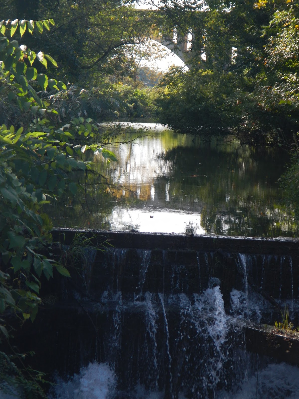
 It turns out that there is a trail on the other side of the canal, and I followed it for a bit, heading in the up-river direction (I was very near the James River here, although I could not see it).  I came to a spot where there was a view up the canal to the distant railroad bridge, which has a beautiful classical style.  You can see one of this bridge's arches in the distance of this photo, snapped into the declining sun to the west.
 I wanted to explore more, but also needed to make sure I got in six miles, so I turned back and in a while, I reached the North Bank trail.  That, along with the Buttermilk Springs Trail, forms a nice seven or so mile loop along the river.  For much of it, you would have no idea that you are near a big city.

The North Bank Trail goes by the back side of Maymont, and comes out on a city street for a little while.  From that point, I turned back along the street and entered Maymont.  It is the former estate of the Dooley family, and they left it to the City of Richmond.  Now, it is a combination nature preserve - gardens - walking trails - historic buildings - generally peaceful spot.  I snapped a photo of this lovely herb garden, complete with an artist painting in the background and moved on to the ...

Italian Garden, which sits high above a water fall that flows down to the Japanese Garden.
I went down the steep slope, and found this nice grotto.  It would have been a nice spot to pray or reflect, but no time in my busy life for that just then.
I moved through the Japanese Garden, which is one of my favorite parts of Maymont.
It has the neat area where you can walk across the stones, which are not in a straight line so that your troubles cannot follow you.  Wouldn't that be nice?  See the colorful koi in the water near the first stone?
After a lot of walking and some running (and passing the pen where the bobcat supposedly lives, although once again, I didn't see him) I was moving uphill and took a picture of these cattle.  The last time I was here, a week or so ago walking with my friend Lelia, the employee with the hay was arriving and these two were going crazy with anticipation, mooing their heads off!
At this point, I moved along a side trail and captured these Sika deer.  They live in Japan but I have seen them in the wild.  They were introduced in coastal Virginia for hunting nearly 100 years ago, and still thrive there.  (Earlier in my hike / training walk, I snapped a picture of a wild creature that I will feature later in a What am I? post.)
From this point, I left Maymont shortly and crisscrossed around Byrd Park for a while to make sure I got in my full six miles.  Either my pedometer is not counting all my steps, or my stride is longer than what I have put in there, because it is under-counting miles by about 5-7 percent.  So I used my watch yesterday to approximate six miles.

Tonight, I go out for a few miles of training at the University of Richmond with some of my teammates.  As lovely as the weather is this week, I cannot wait!

Friday, September 13, 2013

Clues to a Future Hike

The other day, I wrote about a future backpacking trip I will be planning, and how the three of us had to come up with an idea for a trip.  I think we have finalized this now, so here are some clues about where we are going.
1.  This hike is in the state known as "The Mother of Presidents," since four of the first five US Presidents were born there.
2.  The circuit hike is fairly near, just west, to a city that was originally known as "Big Lick."  We might even be able to see this city from some of the mountains.
3.  That's right - mountains.  This hike is not at the coast.  We'll be gaining and losing nearly 8,000 feet over the 36 miles of hiking.
4.  Despite the name given to this hike by some, Secretariat, Seattle Slew, and War Admiral never ran here - as far as I know.
5.  The name referenced in #4 is a result of three spectacular view points along the hike.
6.  A goodly portion of this hike occurs on the most famous long distance trail in the US of A, the one marked by white blazes.  It runs from northern Georgia to northern Maine.
7.  We likely won't find a dragon on this hike, but we may find one of their teeth.
8.  One of the most famous views on the entire trail mentioned in #6 occurs on this hike.  Backpacker Magazine, in a recent issue, rated it as the best outdoor vista in the state referenced in #1.
9.  The last part of the hike as we return to our car and complete the long loop is called the North Mountain Trail.

Friday, September 6, 2013

Planning a Long Hike

The guys who I went backpacking with in June on Shackleford Banks and I were talking the other week about doing a fall trip "somewhere" (which is a great place, by the way!)  We are thinking of maybe a 4 day trip, carrying all of our gear and camping out along the trail for three nights.  But where? 

We've been discussing this lately more and more, and decided that we would each pick a spot this weekend, and then we will discuss the three choices next week and come to a decision.  We are thinking about a place that would be rugged country and within a five hour drive, which could mean up to western Pennsylvania, somewhere in the Blue Ridge or Allegheny Mountains of Virginia, or a number of places in West Virginia.  So part of this lovely fall weekend, I'll be thinking about my proposal for this trip.  I may even get in a hike before work starts again, but given 12 miles for Team in Training early tomorrow, it may not be a long one - or it may not even happen.

It will be interesting to see what we come up with.  I may have to gear back their enthusiasm a bit.  They were coming up with the Adirondacks (best case an 11 hour drive) and the White Mountains in New Hampshire (best case 14 hour drive).  I kept saying "four to five hour drive, guys!"  We shall see, though.

Monday, September 2, 2013

Trail Names

I've read a couple of books lately by people who have done long hikes - one on the Pacific Crest Trail and one on the Appalachian trail.  I just finished the latter one last night, and I find the trail names kind of fascinating.  For example, from the book about the AT through-hike, in 1994, here is a sampling of trail names:  White Rabbit, Del Doc, Boots, Earth Frog, Jett Butt, Methuselah, Sunday, Feather, Geezer, Poet, Magoo, Sher Bear, SourBall, and Gourmet John.  And that is a small subset of long distance hikers that the book's author, Indiana Jean, met on her hike of nearly 2,200 miles.

I don't have a trail name, I guess because I have not done any truly long hikes beyond maybe a week - if that.  My friend Hawkeye (who I am planning a four day hike with later this year) tried giving me Da Vinci (Art) as a trail name but it didn't really stick so far.  Another guy once called me "Professor" once when I was fiddling with my GPS.  And one of my current teammates on the marathon team calls me Pepe' Le Pew (because of my steady, "effortless" stride that eats the miles, not because of the way I smell - at least I think that is the reason)!  But that name would not fit me while long distance hiking, because I would be stopping to suck oxygen far more often than I would keep a steady, never faltering stride. When I was younger, "Kitchen Sink" might have been a good trail name for me, because I seemed to carry everything but the kitchen sink on my treks. But while hardly an ultralight hiker, I have gotten more intelligent about what I pack as I've gotten older.

I guess the thing about trail names is that someone else has to give you that moniker - I don't think that you can pick your own trail names.  So maybe I need to do more long hikes and see what people come up with.

For people out there who happen across this post - do you have a trail name?  If so, what is it, and how did you get it?