
I don't have freedom from bills, so I work. Because weekends are so busy with marathon training and other things, I am trying to take hikes where I find them. Yesterday, I took the second of my lunch break hikes, the first being a couple of weeks ago along the floodwall. For that hike, I essentially went south of where I work, so yesterday, I went east, along the canal, through Shockoe Bottom, and up to Libby Hill. It was four miles long and took an hour and 15 minutes, including time to eat lunch and take a bunch of photos, shared here.
 This is part of the lock system to Richmond's old canals, now under a highway. Cool arch.
 The first part of my walk started in a similar fashion to the floodwall walk, going along the canal. The highrise condo building is one of several pretty new ones along the river and the canal, and is very nice.
 After walking through Shockoe Bottom near the river, I came on these former tobacco warehouses now renovated into condos and restaurants.
 During Team in Training runs in this area, we used to call these the "Cardiac Stairs." I ran up them two at a time.
 I headed east up Libby Hill, which has a nice view of the distant downtown.
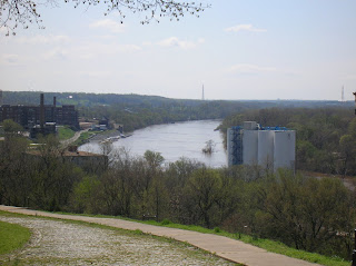 It was this view of the James River that led to Richmond's name, as it reminded the founder of the view of Richmond on the Thames back in England.
 This monument to Confederate Soldiers and Sailors, on top of about a 70 foot column, has a commanding view.
 Spring is very much in evidence throughout this part of Virginia.

 It was in this church that Patrick Henry gave his famous speech. From here, I headed back towards downtown, down a very steep path and another long set of stairs, and headed west towards Shockoe Bottom.
 This house is reputed to be the oldest in Richmond. Whether it is or not, Edgar Allen Poe once lived here, and it is now a museum to him and his work. I've not been in a few years. Will I go again someday? Perhaps; I won't say nevermore.
 On the fringe of downtown, the old train station sits.

 A couple of years ago, this moving reconcilliation monument was built here, to commemorate and remember Richmond's role in the horrific slave trade. Slavery is legally a thing of the past in this country, but we must remember that it is alive and well in many forms (sexual, agricultural, manufacturing, commercial) all over the world.
This is part of the lock system to Richmond's old canals, now under a highway. Cool arch.The first part of my walk started in a similar fashion to the floodwall walk, going along the canal. The highrise condo building is one of several pretty new ones along the river and the canal, and is very nice.After walking through Shockoe Bottom near the river, I came on these former tobacco warehouses now renovated into condos and restaurants.During Team in Training runs in this area, we used to call these the "Cardiac Stairs." I ran up them two at a time.I headed east up Libby Hill, which has a nice view of the distant downtown.It was this view of the James River that led to Richmond's name, as it reminded the founder of the view of Richmond on the Thames back in England.This monument to Confederate Soldiers and Sailors, on top of about a 70 foot column, has a commanding view.Spring is very much in evidence throughout this part of Virginia.It was in this church that Patrick Henry gave his famous speech. From here, I headed back towards downtown, down a very steep path and another long set of stairs, and headed west towards Shockoe Bottom.This house is reputed to be the oldest in Richmond. Whether it is or not, Edgar Allen Poe once lived here, and it is now a museum to him and his work. I've not been in a few years. Will I go again someday? Perhaps; I won't say nevermore.On the fringe of downtown, the old train station sits.A couple of years ago, this moving reconcilliation monument was built here, to commemorate and remember Richmond's role in the horrific slave trade. Slavery is legally a thing of the past in this country, but we must remember that it is alive and well in many forms (sexual, agricultural, manufacturing, commercial) all over the world.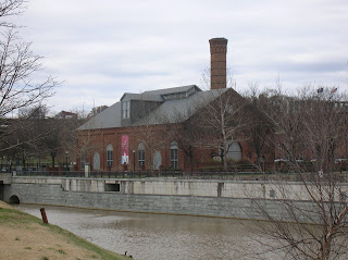 From my office, I walked about a half mile to Brown's Island, a small island on the James. Here is a view of the former
  On Brown's Island is this nice statue, a monument to the African Americans who helped run commerce on the rivers and canals of Antebellum Virginia.
 Looking north and upriver from Brown's Island is Belle Island, former site of a prisoner of war camp in the Civil War and post-war industrial developments. Now it is a nice hiking spot and natural area. I did a
  A little foot bridge extends into the river, and has quotes from people about the fall of Richmond in April, 1865. This one from President Lincoln is poignant, as he was assassinated less than two weeks later.
 I left Brown's Island and walked along the canal, reaching this point on the Canal Walk, with a green cross as a monument to Christopher Newport, discoverer of the future site of Richmond, in the background.
 Part of the flood wall starts here. Note the big watertight door that can be dogged shut in a flood to protect the downtown.
 This is part of a race in a lock connecting a couple of the old canals. There is amazing stone work in this section.
 Before the Civil War, slave Henry "Box" Brown had a white friend nail him into a box and ship him by rail to Philadelphia and freedom. This site along the canal is a monument to him and his courage to undertake this. The "box" is the exact size: 3 feet by 2 feet by 2 feet.
 Part of Richmond's canal walk as I looked back towards the 14th street bridge. I returned from the "Box" Brown monument to cross the river on that bridge.
 Old railway cars along the canal.
 From the 14th Street Bridge, one can see the
  Once I crossed the James, I prepared to climb up on the floodwall for the walk upriver. First, I saw this nice monument to diversity, acceptance, and inclusion at the base of the floodwall.
 Here is a view of the amazing rapids from the top of the floodwall. You can see why Chris Newport stopped at this point. His boats could go no further. These rapids are why Richmond exists here. In the distance is the Manchester Bridge, on which I walked back to the other side of Richmond towards the end of my hike.
 Here is the path along the top of the floodwall, looking north at the Manchester Bridge.
 View from the top of the floodwall looking back south (downriver) from where I had been a short time ago.
 View back to downtown Richmond, where I will return via the Manchester Bridge in the right of this photo.
 As I crossed the bridge, I had a nice view of the floodwall upon which I had so recently tred. Soon it would be back to the office, but with the memories and physical benefits of my nearly five mile leg stretcher.


