Saturday, August 30, 2008

Dutch Gap Conservation Area

I’ve not been sleeping well lately, so I decided that if I slept in today, so be it, but if not, I would just get up and go on a nearby hike. Last night, I set some hiking stuff out just in case, and when I woke up at 5:45, that was my signal to give up on sleeping in for a change and to just get moving. I shaved and dressed, brewed a mug of tea, slipped a Mozart piano concerto – so beautiful – in the car’s CD player, and started driving to Dutch Gap Conservation Area, about 28 miles away.

The trip information I read said that the park opens at daylight, and my goal was to get there as close to sunrise as possible, now that I was awake early on a Saturday. So I was pleased to be driving down the road to the park as the sun was rising over the horizon. This is supposed to be a wildlife rich area, and early morning is the best time to see animals of all kinds. Imagine when my surprise when I made the turn onto the final approach to the park, and there was a closed gate, and a sign saying “Opens at 8:00”. It was now 6:50!

“Well,” says I, “I’ll just walk to the trailhead.” I put on my “waffle-stompers”, got my small day-pack on, and walked around the gate, hiking down the road. There were pretty views of wetlands to the left of the road, and I saw some rails at one point. A little later, there was a view of a couple of dozen egrets and three deer out in the marsh. Two of the deer were six point bucks. In this photo, the white spots are egrets and there is a doe in the lower right of the photo, just to the right of the little tree:


After a mile and a quarter walking, I came to the park entrance. It was blocked with a tall solid fence, with a securely locked gate, with no way around it. In frustration, I admitted defeat, walked back to my car, and drove to a Hardees to get a drink. Then I drove back to the park, getting there at 8:00. On the drive back, I rescued a box turtle crossing the road, my second such rescue of the summer. About 30 seconds after I did so, a car came zipping by doing about 60, and I am guessing that Mr. Turtle would have been road kill without my intervention. A park worker arrived a few minutes later to open the two gates, and in I drove. I parked the car and hit the trail, having already walked 2.5 miles for naught, in heavy hiking boots no less. But saving the turtle made it all worthwhile.

The trail is pretty, with lots of varied water views, and very level. It is mixed use for hikers, runners, and bikers. It is a loop that covers 4.4 miles, the loop being made possible by a bridge that was put in this year. Before that time, hikers would hike 3.9 miles, reach the water, and see the trail that led back to the parking lot just 100 feet away. Then they would turn around and hike the 3.9 miles back.

I didn’t see as much wildlife as I’d hoped, but on this hike today I saw five white-tailed deer, a cotton-tail rabbit, egrets, the two rails of some kind, a blue-winged warbler, an osprey, a great blue heron, a couple of cardinals, a bluebird, Canada geese, a few ducks that I could not identify, a toad, and another box turtle. And on the way back out, I rescued a baby turtle of some kind – it looked like a type of mud turtle. I ended up walking about 8 miles total due to the fruitless early walk and a number of side trips to see water views, and ended up giving myself a couple of blisters. I think these came from (1) only wearing one pair of socks and (2) the easy trail made a faster hiking pace possible, which puts extra pressure on one’s feet.

It was a great way to start Labor Day Weekend! Here are some photos from my hike.

Water view near the start of the hike:


This new bridge turns a 7.8 mile out and back hike into a 4.4 mile loop:


Pretty flowering bush:


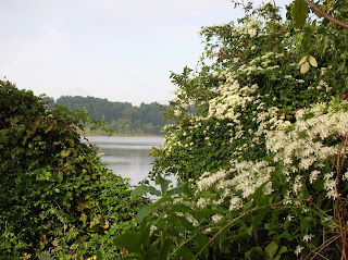
This flower was about five inches across:

A toad along the trail:

This view was typical of the loop that I hiked, although some of the path was out in the open and not wooded:

Interesting mushroom, about six inches in diameter:

Box turtle along the trail, she didn't seem too scared of me:

Pretty flower:

Monday, August 25, 2008

Destruction of Mountains, Right Here in the USA

If you are like me, you love mountains. Did you know that in Appalachia, mountains are being destroyed on a huge scale? The method of mining coal by litterally blowing the top off a mountain is leveling mountains, destroying stream valleys, and ruining communities. It is done on a huge, nearly unimaginable scale. More than 470 Appalachian Mountains have already been destroyed by mountaintop removal mining, according to I Love the Mountains.org. Very few people are aware of this practice or the scope of it, and I would guess that politicians and coal companies want to keep it that way. Only if people get involved and turn up the political heat will there be a chance that this practice will end.

Want to learn more? Go to "I Love the Mountains". Also, you can sign up for more information in the sidebar of my blog, on the right. Just sign up in the portlet that is the I Love the Mountains Challenge. I encourage you to do so.

Thanks,
Art

Sunday, August 24, 2008

Five Year Tumbledown Anniversary!

Five years ago, August 24, 2003, also on a Sunday, I was standing on top of Tumbledown Mountain in western Maine. Now, we are not talking Mount Everest here, so why should this be a such big deal? People climb mountains like that all the time, and in fact on that day there were dozens of folks that we encountered during the hike. But for me, it was a very big deal - it fulfilled a pledge that I'd made to myself more than a year previously and symbolized my victory over cancer. Here is a brief story about how that all transpired, using a note that I emailed to friends after the trip.

Here I am on top of Tumbledown Mountain in Maine, August 24, 2003 - about 8.5 months after finishing chemotherapy for lymphoma:


It was a beautiful day but extremely windy on top. A year before nearly to the day of this photo, I was in the hospital feeling about as ill as I can ever remember with what turned out to be temporary lung damage from bleomycin. Climbing this mountain with Mary and some exceptional friends was a goal that I set near the start of chemotherapy, so reaching the top was a very special moment for me. To me, it symbolized victory over cancer and a return to good health, and the power of friendship.

Before I got ill we had planned on climbing this mountain, in western Maine, with some great friends during the summer of 2002. With the lymphoma, that could not happen, but in July of that year, my climbing friends sent me a beautiful framed photo of the mountain for my birthday with a note on the back that we would still climb it together. Seeing the beauty of the picture, reading the note, appreciating the thought of “bringing the mountain to me”, and realizing that I would not be climbing it that year – and perhaps never - hit me in an extremely emotional way for some reason. I looked at the photo with tears pouring down my face, the only day I cried during my entire cancer saga.

We hung the photo in our kitchen and every day I looked at it. I resolved that by the summer of 2003, I would be well and strong enough to climb Tumbledown. And that is what happened! Even months after finishing the chemotherapy in early December, I was still not back to full strength, but I gradually got strong and healthy enough to make the trip up Tumbledown Mountain with our friends, even though I was a bit pokey at times. We are only talking maybe 8 or 9 miles, but to me it symbolized victory over cancer and a return to good health. Standing at the top looking out over the forests, mountains, and lakes of Western Maine was just an incredible feeling. Many thanks to Mary, Gordeen and Tom, Chip and Amy for climbing it with me on that August day. It meant more to me than I could ever express.

So if during my cancer year, if you paid me a visit, sent me a card or email, called me to talk, helped with chores around the house, visited me in the hospital, thought good thoughts about my recovery or said a prayer for me, then you helped me get up Tumbledown. If you gave me chemo drugs or mixed them for my treatment, provided oncology or medical services, did X-rays or CT scans, nursed me in the hospital, participated in surgery, conducted lab tests or pulmonary tests, then you too were on that hike with me to the top of the mountain. So to all of you, more thanks than I can express.

To expand upon what I wrote to friends back in 2003, this is a great hike. It is near Mount Blue State Park in Weld, and is very scenic. There is a beautiful high altitude pond near the top. Here is a photo of me near the top with the pond in the background.


After seeing the pond, Amy, Chip and I continued to the top. We had to hike down to the pond, losing quite a bit of elevation, then hiking steeply back uphill. I remember being really tired, and thinking that getting to the pond was enough. It was Amy who gave me the determination to keep going. She essentially said "you set this goal, you are so close. Why not keep going another 20 minutes and see how you feel?" So we kept going, and eventually got to one of the summits (there are two or three) where the photo at the beginning of this post was taken. Amy was so right - if I had turned back, it would have really bothered me later not to get to the top of Tumbledown Mountain.

The photo that my friends gave me still hangs in my kitchen, and I look at it often, always feeling inspired when I do so, and thinking of a very special hike on that August day.

Monday, August 18, 2008

Hiking Posts in My Marathon Blog

In my other blog, Racing for a Cure, my primary focus is my marathon and fund raising activities for Team in Training, starting with the 2008 Arizona Marathon. My preparation for this event, and my blog, begins in July, 2007. Now that I am getting ready to start fund-raising and training for my next long distance race, that blog will become very active.

During my marathon training and also my time in Arizona, I got to do a few activities directly related to hiking. If they are of interest to you, you can access them in my other blog.

In July 2007, I spent several days hiking in the Presidential Range of New Hampshire with my brother and a friend. My brother and I celebrated 40 years since the first (and only) time that we had climbed Mount Washington.

In October, I had a couple of unusual training exercises. These included a hike up Mount Tremper in the Catskills with my brothers, and a twenty mile solo hike from Back Bay Wildlife Refuge to the North Carolina border and back.

Then following the marathon, I spent some time in Saguaro National Park and in the Sonora Desert Museum. Both are fantastic, and although I didn't feel like a long walk the day after doing a marathon, I really enjoyed seeing both of these places.

Wednesday, August 13, 2008

Mount Kearsarge

August 5, 2008.
On Tuesday, my brother drove me to east-central New Hampshire where Mary and a couple of friends picked me up from Maine. On the way over, we had time to hike up Mount Kearsarge in Central NH.

The day threatened rain continually, and we drove through some rain, but by the time we got to the parking lot at Winslow State Park, it was just heavily overcast. Nur had done this hike before, and suggested going up a short but steep trail, and descending by a longer, less steep one. The mountain is 2,937 feet in elevation and the trail we climbed goes up 1,100 feet in 1.1 miles. The trail we used to descend is 1.8 miles long and a lot easier, plus it gave us the chance to make a circuit hike out of it.

The climb was steep and very rocky, but not as steep as Mt. Monadnock. We stopped a couple of times to catch our breath during the ascent.


Like our other hikes, the lower levels through were northern hardwood forests, and the upper levels were in spruce – fir forests:


Once we reached the top, there was a short fire tower and a very tall cellular tower. The latter wasn’t the prettiest thing in the world, but I guess that is part of the price of having five bars on one’s phone. A couple of guys hiked in to work on the tower, one of them carrying a 100 pound piece of equipment. The guy not carrying the equipment was the one complaining about having to carry the thing up there and how heavy it was.

Nur told me that on a clear day the view is spectacular, and you can see Mount Washington. But today, we mostly saw clouds. Now and then the clouds would partially break and we would see a hint of some views.


We relaxed for a while on the summit of smooth granite and ate lunch. We asked a hiker to snap a shot of the two of us on the summit of Mount Kearsarge. My brother is a good 4 inches taller than me, but I always seem to pick a spot where the terrain is lower where I am standing than where he is, making him look even taller!

Nur knew of a little bog near the summit, off trail, so we hiked around for a bit on the other side of the mountain until we could find it. Along the way, there were plenty of ripe blueberries, which we helped ourselves to. The bog was very pretty, and is a unique environment near the top of a mountain. With the clouds, it looked a little spooky:

On the longer but less steep hike down, we were chatting about some of the times growing up. At one point, we were discussing a trick we played on a friend, and I told my brother “I felt bad that we did that, but I have never had any remorse about the trick with the wine that we played on our ex-brother in law”. As I told him this, I was descending a steep slab of rock, and suddenly hit a slick spot and started to fall. My legs buckled into a very low squat with a lot of stress on my knees as I slid to the bottom. Quick reflexes and all that marathon training and strong legs and knees prevented me from any injury. We laughed about the timing of me nearly taking a fall two seconds after saying I didn’t feel bad about playing a trick on the former husband of our sister. He said “Hmmm, maybe you should feel some remorse about that trick we played.” Then we agreed, naw, no remorse was necessary for that little incident!

A little later, we passed a grey haired couple struggling a bit on their hike up. Afterwards, I turned to Nur and started to say something, then stopped myself when I realized what I was about to say. So I rephrased it and said “Nur, I was going to say it is cool to see people that age out hiking, even if they are having a bit of a struggle. Then I realized, we are nearly their age!” We both laughed about that. But at least we weren’t struggling. :)

This hike was a perfect end of four days of outdoor fun in the Granite State. It was also the end to any semblance of nice weather, as it rained my entire trip in Maine.

Tuesday, August 12, 2008

A Day on Bald Mountain

August 4, 2008
Unlike Modeste Mussorgsky’s rather demonic composition, “A Night on Bald Mountain”, our day on Bald Mountain in Antrim, New Hampshire was tranquil and peaceful, filled with beautiful images of nature rather than musical images of nasty witches, imps and demons. It was the nicest day of my whole week in New England weather-wise, only raining for about 20 minutes, so we took our time to explore nature along the way – no rush at all.

We started on the Tudor Trail, which follows along a simply gorgeous northern New England pond, Willard Pond.


There we saw a cute baby loon and his mom and dad, who serenaded us with their haunting but beautiful calls. I joked with Martha that they were singing “Happy Birthday” to her on her special day. If you have never heard the incredible cries of loons, then do yourself a favor and head to a remote northern lake someday. It is like nothing else I've ever heard, and I miss it all the time since leaving Maine more than 15 years ago.


Along the trail by the lake, there were many interesting mushrooms and trees. We saw red, orange, yellow, chocolate, and even lavendar mushrooms:


The trail was about a mile long, and reached a lovely point near the far end of the pond that was covered with large white pines. It had the feeling of a sacred cathedral, and we lingered there for a very long time. Across the pond, back the way we had come, was a view of our ultimate objective of the day looming 900 feet over the pond, Bald Mountain.


We reluctantly left the piney point and retraced our steps back to the junction with the Bald Mountain trail, along the way crossing a wide stream on a very difficult series of slippery rocks. It was on this return crossing that Martha slipped and fell into the stream, getting soaked from the waist down, including her boots and socks. Happy birthday, Martha! She is such a good sport, and complained not a bit.

The Bald Mountain trail is 0.8 miles long, and climbs steeply at times 900 feet to the top of the mountain. It goes through typical northern hardwoods and later through a zone of red spruce. Along the way, we saw this little fellow, a red-backed salamander.


He was the second salamander we saw on the hike, the other being a red eft. Since I posted a photo of a red eft under my description of my Riprap Hollow hike a month ago, I won’t repeat one here.

A couple of hundred feet from the top of the mountain, we came upon a perfect lunch and resting spot. It was a series of “eyebrow” cliffs overlooking the beautiful pond. We lingered here for a long time, looking at the views and eating ham and cheese sandwiches made on the spot. Here is a view of Willard Pond from these ledges. The pine-covered cathedral-like point sticks out into the top of the pond from this perspective:


As we walked along the ledge, with yours truly sliding on slippery reindeer moss on a steep section and landing on my butt before I could slide off the mountain, we saw this nice view of our hike of two days ago, Mount Monadnock:


Eventually it started to rain so we packed up, put the cameras away, and started to head up the remainder of the climb, hiking into the red spruce near the top of the mountain. At one point, Bald Mountain was treeless on top due to a forest fire, but apparently it has since joined the “Hair Club for Men”, because it was not bald at all but heavily timbered with no view on top. There was a small bald spot on the very top of flat granite, surrounded by spruce, but it was raining too hard to take a picture. We all joked that if Donald Trump were to develop the mountain into some type of nutty resort, he would put a "comb over" across the granite bald spot.

We continued down the Tamposi Trail on the other side of the mountain as the rain gradually slackened and then stopped. It was a pretty path down through the hardwoods, again with many colorful mushrooms. I think I saw more different mushrooms on this path than on any place since the Great Smokey Mountains National Park many years ago. We also found a neat little cave on the way down, which we explored a bit.

At the bottom we changed into our swim suits and took a nice refreshing dip in the pond. It was windy by then so getting out of the water all wet was a bit frigid, but the swim capped a another great day in the outdoors.

Here is Martha on her birthday with Nur:

Monday, August 11, 2008

Kayaking the Contoocook

August 3, 2008.
When we woke up Sunday morning, we were all just a bit stiff and tired in the legs from the tough hike the day before, so we decided to rest our legs a bit and use our upper body instead. A kayak trip down the Contoocook River seemed like the ideal thing to do. Because the forecast called for afternoon thunderstorms, we left mid morning to go rent a kayak for me. Nur and Martha each have their own.

After dropping off a shuttle vehicle, picking up the boat and scouting around a bit, we found a semi-decent place to put in. It was a little below the dam that is below Peterboro, NH, but the river is constricted at the put-in point and flowing very rapidly. Later, we found a better place just upstream of where we put the boats in but it was way too late.

We were going to put in at the bank and then paddle across to the left hand side of the stream, since the right hand side was shooting down its own channel in a different direction. We quickly learned that the current was much too swift to do this, and so each waded to the middle of the river to get in at a small island that divided the river into two channels. With the skill and agility of ballet dancer, I slipped into my kayak. Whoops, let me rephrase that. With the skill and agility of a bull moose walking along a tightrope, I slipped getting into my kayak, spilling the contents and myself into the river, and putting about 5 gallons of water in the boat. In the confusion, my canteen was swept away in the current. Fortunately I had bagged my camera into a zip-lock baggie and strapped it down. But it meant paddling all day with soaked shorts, which later turned out to be no big deal.

The river was beautiful, with a slow current most of the way of 2-3 knots, and some occasional fast sections and Class 1 rapids that were fun and got the adrenalin rushing a bit, since none of the three of us are expert paddlers. Most of the time, the Contoocook flowed through forests, with a few areas near fields or even a bit closer to civilization.


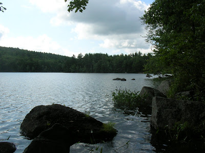
We found a little muddy beach to take a lunch break, and right about the time we finished eating the rains came. The first two were brief little squalls that we heard before they got to us, passing by quickly. The third and final one came to stay, and was a downpour at times. At this point the wet shorts didn’t matter a bit, because we were all soaked. During this time, Martha saw a mother mink and three babies along the bank. It was raining too hard to try a photo. Other than this, the only wildlife we saw was a painted turtle on a log; a couple of kingfishers, flying along making their cool rattling call; and a couple of GBH – great blue herons.

We did see some pretty flowers, like this cardinal flower:


And this patch of pickerel weed:


After an hour or so, the rain slackened and finally quit for good. We were continuing to hear thunder ominously close by, and kept paddling downstream keeping a nervous lookout. The sun came out, and was very welcome as all of us felt chilled by the cold rain. The sun was strong enough to dry my shirt after an hour, as we finished our beautiful paddle down the Contoocook River. We took out at a little park near the covered bridge just before Powder Mill Pond, where we had left the shuttle car. I would guess that we paddled about 10 miles on the river, but it may have been somewhat less. We had not thought to track the trip with a GPS so that we would know the mileage, but it really doesn’t matter. It was just great fun in a pretty spot in the outdoors, however long it was.

Sunday, August 10, 2008

Climbing Mount Monadnock

August 2, 2008.
Mount Monadnock in Southern New Hampshire is only 3,165 feet elevation but feels and looks much higher. For one thing, the trail up is very steep. For another, a very large amount of the mountain is above the tree line and is an alpine zone. It is the most climbed mountain in North America.

The three of us hiked up the Marlboro Trail, which is only about 4.5 miles round trip but very, very steep. It climbs about 1,800 feet and most of that climb is in the last mile and a half. I think that the trail gets its name because at times one is breathing so hard that it feels like one has smoked a pack of Marlboros (not that I would know for sure since I have never smoked). The first part of the trail climbs nicely through a pretty northern hardwood forest, with some level areas.

Indian Peace Pipe in the lower hardwood forest:


Once you get past the lower section, there is barely a level spot until you reach the summit – it just climbs and climbs, often at a very steep pitch. I kid you not - a few times we came on a 50 foot section of trail that was pretty level and we practically rejoiced! There are pretty views as soon as one climbs out of the forest onto a very large exposed rock face.


The summit looks deceptively close at this point, and not too high, but it is all an optical illusion. There is still plenty of climbing to do:


The path keeps climbing, with hardly a switchback. You do plenty of scrambling over and around rocks, often using your hands and placing your feet carefully so as not to trip or slip.

We helped ourselves to blueberries along the way. It gave us an excuse to pause to catch our breath. A few times, we sat on the rocks and rested, waiting for our pulse and breathing to return to normal. Not far from the top, a shirtless man celebrating his 75th birthday came down at a good clip. He looked in pretty good shape for a 50 year old, much less 75!

For a while, the trail left the exposed areas and reentered the forest, but at the higher elevation it was spruce – fir rather than hardwoods. The trail continued to climb steeply through the trees, and most of the time we walked over rocks.


A quarter mile or so from the summit, all exposed rock, the climb became more gradual for the remainder of the hike:

There are great views, and supposedly on a clear day one can see all six New England States, the Atlantic Ocean, and Boston. Alas, our day was far from clear, but even so the views were impressive.

We were only minutes on the summit when the distant thunder started to become more ominous, and a ranger ordered everyone down. So we complied, but paused on one of the last ledges on the way down to eat lunch. The first rain drops began to fall after this point, and the rain gradually became close to a downpour, soaking all of us to the skin. Frankly, we seemed too close to the car to bother with rain gear. Fortunately the worst of the rain didn’t happen until we were mostly off the steepest sections. Even so, the steep rocks were slippery and treacherous, and the going was slow. Martha slipped at one point, skinning her knee badly and twisting her ankle, but the injury was not serious.

Shortly before the rain started I was able to get this photo of some pretty pink spirhea:


We got back to the car a little chilled, soaked, and tired – the steepness of the trail made it seem more like 8 miles than 4. However, we all enjoyed getting to climb this famous mountain, the first time for all three of us.

Background on My New Hampshire Trip

Well, the original idea was to backpack in Baxter State Park in Northern Maine for four days. My brother Nur, sister-in-law Martha, and I had made our reservations for the Chimney Pond and Russell Pond campgrounds, and were looking forward to the experience, which would include climbing Maine’s highest mountain, Mount Katahdin.


Then, a couple of months ago, Nur unexpectedly learned that he has diabetes, and the trip to the wilds of Maine, miles over very rugged terrain from a car, was not going to happen. He needs to adjust to his treatment plan first. So instead, we got together at their home in Southern New Hampshire, and the three of us spent 4 days doing day hikes and kayaking. We climbed Mount Monadnock, Bald Mountain, and Mount Kearsarge, and kayaked the Contoocook River.


Here are the three of us on top of Mount Monadnock. From my closed eyes, you might think that I am scared of heights, but it is not so.