Wednesday, October 29, 2014

Through-Hikers and Trail Magic

During my aborted hike along the Appalachian Trail in Shenandoah National Park, I spent the second and last night of the trip at the Pass Mountain Shelter.

I was hiking alone at that point, since my hiking partner, Hawkeye, had blown his knee out a few hours earlier.  I wondered if anyone else would be at the shelter, and when I got there, I ran into Ozone and Mittens, a father and his young son who we had run into on and off the past two days.  They were getting ready to leave the trail as Ozone was worried about his son's sleeping bag keeping him warm that night.  As it turns out, it was not nearly as cold as the prior night.

Shortly after they left, a through-hiker, Dirty Bird, showed up.  We chatted for a bit, and then five other through-hikers rolled in, one or two at a time: Hydro, Max, String Bean, Toast, and Ducky. They had started hiking in northern Maine, at Mount Katahdin, in July, and had the goal of reaching Springer Mountain in Georgia before Christmas.  I really enjoyed chatting with them and hearing their stories from the trail as we cooked dinner.  One of them reconstituted a campfire from the embers that a big party of picnickers had left, and we talked around the fire for several hours.  A few of the hikers came in well after dark, hiking by headlamp.  They were all lean and fit, used to putting in 15-25 miles a day on the trail.  Most were pretty young but Max was 50, and doing the hike as a way to celebrate the Big Five-O and attain a life-long dream.

As people were starting to cook their suppers, Max said "I need to get a new stove.  I have not had a hot meal on the trail since the 100 Mile Wilderness (which is in northern Maine) when my stove broke."  I said, "You know, I have plenty of food, go ahead and pick out a meal."  Max said, "That's too generous, I could not ask for that," to which I replied "You're not asking, I'm offering.  Go ahead.  My food bag is hanging from that tree over there.  Pick out a meal."  So he did, picking out my "Curry in a Hurry" that I packed since I like it so much.  I fired up my stove, and he just kept thanking me over and over, saying how much he was going to enjoy the hot meal, and how much he loves curry.  And he did obviously savor it!  He said "I never, ever expected to receive 'Trail Magic' at a trail shelter."  His last words to me when he left the shelter in the morning were "Thanks again for the meal, Warrior!"

"Trail Magic" is when someone does something nice for a through-hiker: gives them a ride, offers them a place to stay off-trail or a meal and a hot shower, lets them wash their clothing, hands out snacks or candy or cold drinks at trail junctions, and so forth.  It is a good thing to do, because these folks endure a lot of hardship and discomfort to attain their dream of hiking the 2,180 miles of trail.  So I was glad that, in some small way, I could make a fellow hiker's day a little more enjoyable.

Saturday, October 25, 2014

Return to Mount Pleasant for a Pleasant Hike

It was hard being at work all week, because I was supposed to be backpacking.  But I didn't dwell on it and, yesterday being my regular every other Friday off, I decided to hit the trail and return to Mount Pleasant (east of Lexington).  I was there four years ago with some fellow hikers, but yesterday, I hiked solo.  Unlike the last time when it was drizzly and cloudy, it was partially sunny yesterday.

This is a moderately strenuous 5.6 or so mile hike, certainly not a stroll, but nor is it a "quad buster."  There are fantastic views from each of the two spurs at the summit, and those are the highlights of the hike.  The elevation profile shows a gain and loss of about 1,500 feet.  But compared to hiking last weekend with a 40+ pound pack, yesterday felt pretty laid back, even on the uphill sections.

Here is a track for the hike, starting and ending at the purple star, and hiking counter-clockwise on the Henry Lanum Memorial Trail.  At the lower right corner of the map, you can see the side trails to the western and eastern spurs of the Mount Pleasant summit.  You have to climb a very steep rock pile of about 7-8 feet to get to the western spur.  Being by myself, I did that very carefully, especially coming back down.

There was a pleasant little stream for the first part of the hike.

Lady in red

Most of the trail was good footing, but all the leaves made things treacherous at times.  They get slippery when on walks downhill, and they cover all kinds of small rocks that are potential ankle breakers.  You can see that there is some color still in western Virginia, but not a lot.

I decided to do a panorama of the forest from the trail.

On the way to the summit, I talked to two ladies who were backpacking.  They had spend a cold and windy night on Cold Mountain the night before.  A short time after speaking to them, I reached the western spur of the summit:


From there, I went on to the eastern spur.  Can you imagine the views from here at sunrise and sunset, or when the fall colors are at the peak?


I don't get a lot of photos of myself - maybe that is a good thing - but I set my camera to timer on the eastern spur of Mount Pleasant, placed it on a rock, and snapped a "selfie"

I liked the color contrasts - red, white, and blue!  Mother Nature was liking the good old USA!

After leaving the summit, I hiked several miles through the woods back to my car, and then got on the road.  I liked the way the sun hit the trees on my ride back out towards the main road.

Tuesday, October 21, 2014

How a 108 Mile Hike Turned into a 28 Mile Hike

For several months, Hawkeye and I had looked forward to our 108 mile hike on the Appalachian Trail from north of entering Shenandoah National Park to the south end where the trail exits the park at Rockfish Gap.  Finally, last Saturday morning, the big day arrived and we hit the trail about 7:30, heavy packs loaded and on our backs.  We were to be joined for the first two days by first-time backpacker Imad, who later earned the trail name of "Best View."  He had left his car at Skyline Drive mile post 28 the night before and Hawkeye's wife gave us a ride to Front Royal for the night, and then to the trailhead Saturday morning.  Best View would get his car late Sunday afternoon, and Hawkeye and I cached most of our food in his car to lessen our weight for the first two days of hiking.  After getting back the car, we would load our food and continue down the trail for about two miles for our Sunday destination, the Pass Mountain Shelter, and then onward for seven more days and 85 more miles.

That was the plan.  Like many plans, it unraveled when Hawkeye's knee blew out late Sunday about a half mile from the car.  We got him to the tiny car with less than two hours of daylight.  My car was 85 miles down the road at where the hike was to end this coming Sunday.  There was no room for three men and three large packs in the Mini-Cooper.  We effectively had two choices - Imad could drive Hawkeye home, or he could drive me to my car, and I could return to Hawkeye and give him a ride home.  This second option didn't really occur to me until later, when my wife pointed out that we could have done that, and really, should have done that.  It would have meant that Hawkeye would have to wait alone by the road for about 5 hours, and I would have gotten back to him about 9:30, three hours after dark.

What we did was option 1 - Best View took Hawkeye home, and I continued the hike alone.  When I got to camp, I sent my wife an update with the InReach telling her what had happened, and that if she was concerned about me hiking the next week alone, I would come home Monday.  She was concerned, and so that is what I did, hiking out Monday morning and hitching - with great difficulties - rides to my car.  Yeah, doing the car shuttle thing would have been smarter, but at the time it didn't occur to me and I was comfortable continuing to hike.

Here is a map of how far we got.  We started at the top where the AT (red dashed line) crossed Route 522 where the red arrow is.  The Skyline Drive is the heavy mustard line.  Saturday night, we camped at the Gravel Springs Hut after hiking nearly 14 miles (purple star).  The loop trails (pink, blue, and orange) in the middle left was my route of my Thornton Springs three day hike from two months ago, a few miles of which was on the Appalachian Trail.  The orange arrow was where Best View's car was and where Hawkeye and Best View went home.  At the red star is the Pass Mountain Hut, my home for Sunday night.  And my hike ended at the bottom at the purple arrow when I left the AT to hitchhike to Rockfish Gap.  Best View did reach me by InReach Monday to tell me he would come back after work to get me if I needed a ride, but I managed to eventually hitch a ride to my car with two very kind ladies.

Yeah, disappointing for sure, especially for Hawkeye, who can't walk right now.  Hopefully, he will heal quickly,

Here are some photos from my two (and a fraction) day, 28 mile hike, covering the Appalachian Trail in the northern part of Shenandoah National Park.

Hopes are high at the start of the hike, as Hawkeye, me (Warrior being my newly bestowed trail moniker), and Best View prepare to start hiking the storied Appalachian Trail.

This is the only bear we saw, and he is a patriotic bear!  However, the second night when I reached Pass Mountain Hut, a man who was hiking out with his son told me they had seen a large bear just before reaching the hut.  We all hung our food for the night.  We did see a number of deer.

Autumn is well underway, as seen by this lovely maple leaf.

Best View and Hawkeye early on one of our many climbs.  Most of the first day was uphill.  We started at 900 feet and camped the first night at about 2,500 feet.  We crested North Marshal Mountain along the way at more than 3,300 feet, and probably gained over 4,000 feet during the day with all of the ups and downs.

The view from Possum Rest, at the Shenandoah National Park boundary on the AT.  This was 3.7 miles and 1,400 feet higher from where we started.

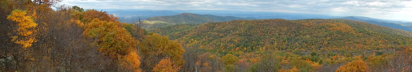
This is the panoramic view from Compton Peak at 2,900 feet, where we had lunch on day 1.

Best View enjoys one of the "best views" from North Marshall Mountain, at 3,300 feet.  I think he really enjoyed his first backpacking trip.

Because we could leave all but one day of food in Best View's car, we each decided to cook a deluxe meal the first night.  Here was mine, before cooking it in the fire.  To top it all off, Best View packed in several bottles of IPA and Stout.  That IPA with dinner hit the spot!  Steak and beer - a backpacking luxury!

We camped that first night at the Gravel Springs Hut, setting up tents nearby.  My site was terrible, sloping away downhill.  I slept horribly on the slanted ground, but got to listen to owls calling off and on.  Before bed time, we enjoyed chatting with the other hikers, many of whom were through-hikers coming down from Maine.  One was doing a "yo-yo!"  He had hiked from Springer Mountain to Mount Katahdin, and now was reversing the trip back to Springer. 

On Sunday, we broke camp as early as we could and hiked uphill for nearly nearly four miles to start the day to crest Hogback Mountain at nearly 3,500 feet.  It was a cold and windy morning, probably about 34 degrees when we woke up.  The winds were awful.  Here I am just before the final 500 foot climb to Hogback.

View of the Shenandoah Valley near the trail up Hogback Mountain.

Panoramic view of Hogback Mountain.

Sometimes we hiked together, other times separately.  I was ahead of Hawkeye when I reached this spot on the Skyline Drive, our agreed rendezvous point about 1/3 mile from Best View's car.  I had no idea that Hawkeye had injured his knee out a quarter mile or so behind me, ending his hike at this point.  With sundown approaching, I decided to continue the hike alone.

I reached the Pass Mountain Hut - a truly beautiful camping spot - with an hour of light to spare.  The hut was built by the CCC in 1939.  There is a great spring, a privy, and excellent tent sites.  The shelter can comfortably sleep at least 10.  Seven of us slept there, the other six being through-hikers Dirty Bird, Max, Hydro, Ducky, String Bean, and Toast.

Here is where I laid down my bedroll for the night.  It was not as cold, and unlike the prior windy night, it was calm.  I slept better, despite a little bit of snoring from the five other men and one woman sharing the hut.  I did hear an owl call, and I heard coyotes during the night - hard to hear over the snoring, though.

In the morning, I caught the sunrise at the exact moment through this large tree in front of the shelter.

Since I had decided to end the hike and hitch back to the car and head home (instead of a third day of hiking with 15 miles originally planned), I had a leisurely breakfast and a couple of mugs of hot tea as the six through-hikers chatted, ate, packed up, headed off.  They were more than halfway through their 2,180 mile stroll, all having left northern Maine in July.  More about them in a later post,

From the hut, I packed up, hiked the 1.2 miles out to Thornton Gap, and started hitching rides.  It was much more difficult than I could have believed to hitch though a national park with a big backpack.  I guess people assumed I was dangerous.  Too bad we have come to that as a society.  But eventually, two kind ladies took a chance and gave me ride the last 55 miles to my car, going out of their way.

Wednesday, October 15, 2014

Harrington Beach in Eastern Maine

After our visit last Tuesday to Quoddy Head State Park, our nephew and niece-in-law suggested a short hike in to Harrington Beach, which was close by.  Here are a few photos - great place to be gained for an easy hike of just a few hundred meters.

Beach plums at the start of the hike.

Definitely not in Kansas anymore, Toto!

Here is a panoramic view of Harrington Beach

No sand here!  Maine has something like 3,000 miles of coastline and only something like 30 miles of it is sandy beaches.

Can you tell that there is a huge tidal range there, something like 24 feet?  That pales in comparison with the Bay of Fundy if you keep heading northeast.

No, this is not Harrington Beach, but it is a quintessential Maine coastal view in nearby Lubec.  The bridge to Campobello Island in Canada (FDR's summer place - well worth a visit) is very close by.

Tuesday, October 14, 2014

The Easternmost point in the US of A!

Last week, we left the Maine mountains, and headed for the "Downeast" region - the part of Maine that juts eastward towards Canada.  While we were there, we took a short hike at Quoddy Head State Park, and the light at East Quoddy Head, the easternmost point in the USA.  Here are some photos from this trip.  It is a spectacular and beautiful spot, and how can one not fall in love with the lighthouse?


A lobster boat cruises past Sail Rock, with Grand Manan Island in Canada in the distance.

We hiked down to the beach, catching a view back to the lighthouse above us.

The beach there is a traditional "cobblestone" beach - no sand here, and with water temperatures rarely if ever out of the 50's, it would be a chilly place to take a dip.  Add in 25 foot tides and it would be downright dangerous.

Panoramic view of the beach and the lighthouse.  Click to enlarge.

The carving on the rocks proclaims this as the easternmost point in the USA,

and no American flag on US soil flies further east.

Here is a look back to the lighthouse, with Grand Manan Island in Canada far in the distance.

Monday, October 13, 2014

Western Maine Views

We spent last week in Maine, seeing friends and family and getting to enjoy the crisp Maine October weather.  We also did a few short hikes, so I thought I would post about these.

The first, recorded in this post, was not a hike as much as some short walks in various scenic places as we drove along.  Therefore, I will just post a few photos that I took of the day we spent traveling around the Rangely and Mount Blue areas with two wonderful friends.

This is a panoramic view of Rangley Lake from the east, just south of the town of Rangely.


 And here is a shot of the same large western Maine lake from the west later in the day.

This is a view of Mooselookmeguntic Lake from the southeast.

Fall colors along the Swift River.

The Swift River pours though Coos Canyon.

Coos Canyon.  Decades ago, I took my son and my nephew camping at Mount Blue State Park near hear, and we took a swim in the canyon.

Mount Blue from the shores of Webb Lake in Mount Blue State Park, one of my wife's and my favorite Maine state parks.

Panoramic view of Lake Webb in Mount Blue State Park.

Tumbledown Mountain (left), site of my all time favorite hike of the last dozen years or so, my hike to celebrate beating cancer.