Friday, April 19, 2013

A Stroll on the Richmond Liberty Trail

You've heard about the newly marked Richmond Liberty Trail, right?  What do you say we walk it today, just you and me?  Come on!

The Richmond Liberty Trail is not a true trail, but an urban walk along city streets and, for a little bit, canals.  It is a 6.2 mile walk according to the official information, but as we will learn later from my very accurate GPS, we'll end up walking nearly 7.5 miles.  We'll see lots of Richmond's historic sites and neighborhoods along the way.  Part of the Liberty Trail joins the Richmond Slave Trail, which is described here in my walk of about a year ago.  Some of my other blog posts that either intersect the Liberty Trail or can be reached from it are these:  Black History Walk, the James River, walking to Great Shiplock Park, viewing the great blue heron rookery, hiking around Belle Island, Give me Liberty or Give me a Hike, historic Tredegar Iron Works, and hiking the Buttermilk Springs Trail.  So you can see that there are a lot of nice walks in Virginia's capital city that are in or connect to the downtown.

You won't need hiking boots, just a good pair of shoes for our hike.  The weather looks very warm and potentially stormy today, so bring a good hat - we'll need to stay alert.  Oh, and pack some water and a lunch.  Ready?  Let's go!

We park along 5th Street near Tredegar, marked on the map by the purple arrow in the lower left of the photo, and start heading up the steep hill, walking the route more or less in a clockwise.  It's already very windy, and you laugh as my hat nearly blows off!

Within feet, we come to a freshly painted "trail marker" on the sidewalk.  These will be spaced every 100 feet or so and will guide us for the entire route.


At 5th and Franklin, I suggest a quick visit to Liverpool by popping in to the always-welcoming Penny Lane Pub.  Surely we have some time for Shepperd's pie and a cold Newcastle brown ale.  You remind me that we only just started our walk, and that we have lunch packed.  Ah, another time!

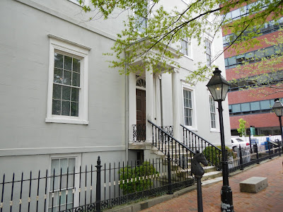
Shortly, we pass by the historic Kent-Valentine house.  They obviously lived in grandeur in their times.  Then we make our way towards Jackson - Ward, a historically African-American part of the city.
There, we go by the Black History Museum of Virginia.  We both wish there was time for a visit, but the "trail" beckons.
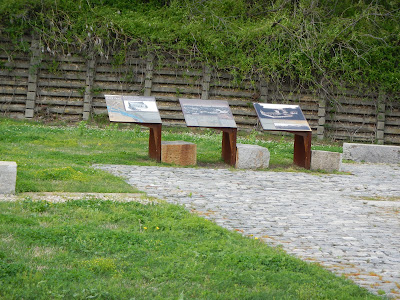
Along the way, we will see many historical and informative markers, such as this one about Quality Row, a section of Jackson Ward where more affluent blacks lived.
As we leave downtown, we pass by the historic Carpenter Theater, now part of Richmond Center Stage, and main home to the Richmond Symphony Orchestra and a performing arts venue for many other groups.  Hey, The Virginia Opera will be performing "The Marriage of Figaro" by Wolfgang Mozart next weekend.  Wanna go?  You remind me that opera is not your cup of tea, although you have never really seen one.  I suggest trying this one - if you end up not liking this masterpiece, you probably won't like any opera.  But chances are you will like it.  To me, it is 3 hours of musical heaven, and very, very funny to boot.  I was once convinced that I didn't like opera, until I found that I do like much of it.
Along Marshall Street, we pass the home of John Marshall, the fourth chief justice of the US Supreme Court.  We must take the tour sometime!
As we approach the Court End section of Richmond, bustling with actively from VCU's huge medical center, we decide to take a break on a quiet bench to drink some water and eat lunch - peanut butter and orange marmalade for me, Swiss cheese and baked ham for you.  "Pardonnez -moi, monsieur, mais avez-vous un poupon gris?" you ask with a smile.  "C'est dommage, mais non.  I don't usually carry Grey Poupon mustard on a hike," I reply.  We finish lunch and walk by the White House of the Confederacy, now a museum that is furnished as when Jefferson Davis lived there.

Just a few feet away is the Museum of the Confederacy, which is excellent.  Whether you think the Confederacy was a great or a terrible idea, this fine museum is worth a visit.  Outside, an anchor from the CSS Virginia is on display.  Good luck lifting it!

A young woman sits on the curb, face down in her hands, clearly weeping.  Given the hospital right there, I imagine she just got some bad news about a loved one.  We feel badly for her.

We head along the route towards the State Capital.  The first thing we see there is the wonderful Virginia Civil Rights Monument, which commemorates the end of "separate but equal" and full civil rights for all, regardless of race.

Patrick Henry may have said "Give me liberty, or give me death," but it was George Washington who risked death to make liberty happen.

We marvel at the lovely spring colors,
As we pass by the capital building - designed by none other than Thomas Jefferson - and the historic bell tower.

I am two blocks from the office at this point, but not even remotely tempted to go there on my day off, so we keep walking.  At Franklin and 15th, we come to the Reconciliation Memorial.  There are identical statues in Liverpool and Benin, which were legs in the evil triangle of the slave trade.

We make a little detour to see the site of the infamous Lumpkin's Slave Jail, a holding area and torture center for escaped and uncooperative slaves, and a "holding pen" for slaves being sold down the river.  The horrors of this place, once known as "The Devil's Half-Acre" among Richmond's black population, are now long gone.  A old African burial ground is very near by.
The oldest house in Richmond is now a museum to Edgar Allan Poe, although I don't believe Poe actually lived in this house.
This building occupies the former site of the Van Lew mansion.  Elizabeth Van Lew was a dedicated abolitionist who operated a spy ring for the Union during the Civil War.  She was reviled by her neighbors at the end of the war.
We are stirred by the sight of St. John's Church, where Patrick Henry gave his stirring "Give me liberty or give me death!" speech on March 23, 1775.  The church is in a neighborhood of restored row homes.


As we head back near the river, we are moved by the sight of the Virginia Holocaust Museum.  Something like 10,000,000 souls perished in the Holocaust, driven by one evil madman.  The box car sitting out front (to the right in the photo) is representative of those that men, women, and children were crammed into to take them to the death camps operated all over Eastern Europe.

On to more peaceful thoughts, we walk along the canal as we head back to Brown's Island,
where "The Headman" plies his craft in front of cherry trees.
We cross over the bridge and glance at Tredegar Iron Works, now Richmond's Civil War center.  We are just a tenth of a mile or so from the car.
I'm really glad that you came along on our walk of Richmond's Liberty Trail.  I know that I enjoyed it very much, and hope that you did as well.

Sunday, April 14, 2013

Is God a Team in Training Fan?

Anyone who knows me knows that I a fan of Team in Training, the Leukemia and Lymphoma Society's endurance athletics program to raise money in support of their mission to cure blood cancers and support blood cancer patients.  Starting eight years ago, I've done five events with Team in Training, while raising money from generous people in each one: the Midnight Sun Marathon in Anchorage, Alaska; the San Diego Marathon; the Arizona Marathon in Phoenix, Scottsdale, and Tempe; the Country Music Half Marathon in Nashville, Tennessee; and the Seattle Half Marathon.  Along the way, I got to see parts of the country I'd never seen, and also got to do some things in the great outdoors, such as seeing my first grizzly bear in Lake Clark National Park, and hiking in Saguaro and Mount Rainier National Parks.

Completing a marathon or half marathon - especially the first time - is an amazing feeling.  Completing one as a cancer survivor?  Well, that magnifies that feeling ten-fold!  Plus, I have met many incredible people through Team in Training.  When I am doing it, I do tend to hike less, which is one negative.  When you are running five days a week, several of them long distance, it takes away from then energy one has for hiking and for other things.  But I am still a big fan.  I hope to do my sixth event this year, if my left knee and right foot cooperate.  I may have to do the event as a walker rather than a runner, but that is perfectly okay.

But what about God?  Is God a Team in Training fan?  Well, on Thursday's hike to Staunton River State Park, I found conclusive evidence that the answer is "Yes!"  Here it is, in TNT's purple and green colors:


As I stood there, I thought I heard a faint "Go Team!" carried in the breeze.

Actually, believe that God is a big fan of anything we humans do that is good for ourselves and for others, and Team in Training qualifies, big time! 

Saturday, April 13, 2013

What Am I?

I saw this mercurial creature on my hike two days ago in Staunton River State Park.  It took me persistence and moving at a slow pace, but I was able to get some photos eventually.  See if you can figure it out, but I warn you, this is not an easy one at all!

You humans say my blood runs cold
I say that statement's rather bold!

I just follow natural rule:
My red blood might be warm or cool

My skin is coated in small scales
From tip of snout to end of tail

With my four legs I move quite well;
Unlike a turtle, I have no shell.

I move around as I do please
I climb up trees with complete ease

I'm half a foot or more in size,
On full alert to stay demise

Because I could be tasty meal
For many creatures - that's for real!

Light brownish color is my base
What, puzzled look upon your face?

I've wavy bands across my back
Of lighter color and of black

The bands turn orangish near my tail
Are you now close? Will you prevail?

This one is tough, in your defence
Take your guess now, I'll end suspense!

Hopefully, you
now have enough
clues to at least
get the kind of
animal, if not
the exact species.
Scroll
D
O
W
N
for the
answer!

If you guessed northern fence lizard
I think you're probably a wizard!

There are relatively few kinds of lizards in Virginia, and this must be the biggest.  They are expert climbers, and like a squirrel, will continually move to the other side of the tree as you try to get a good look.  But eventually, this one - a female based on the coloration - settled down and I was able to get some photos of her.  It was pretty neat!


Friday, April 12, 2013

River Bank Trail in Staunton River State Park

I was supposed to have Friday off from work, but meetings got scheduled, so my boss said that it was okay to switch my day off to Thursday.  Unexpectedly having that day off on my hands, I decided to go hiking.  Imagine that!  I packed my pack - including emergency gear I knew I would not need, but you should always be prepared - and headed out for the 2.5 hour drive.  My goal: to hike the 7 mile River Bank Trail, shown here with my start and end at the purple arrow, in Staunton River State Park in the southern Piedmont of Virginia.  I hiked this route clockwise.

Staunton River State Park is at a peninsula where two rivers, the Dan (south) and the Staunton (north), converge at the John Kerr Reservoir.  The hike is pretty easy, with some elevation gain and loss - profile below - but nothing too steep.  Although this may look steep, keep in mind that between the high and low elevation, there is only about 160 feet (about 50 meters), and the total elevation gain and loss is only 961 feet over 7 miles.  Still, seven miles is seven miles, and I am also dealing with a chronically sore left knee and a newly sore right foot, so it felt like plenty.

It seems as if winter gave way to summer instead of spring.  Our dreary, wet, cold March turned to April with five straight days over 80 degrees F.  Included in this streak was one day over 90!  Along the way, everything that should have bloomed in early March, mid-March, late March, and early April in our normal prolonged spring bloomed all at once in early April.  Yesterday, when I hiked in Staunton River State Park, the high was an unseasonably warm 82 degree.

I'd hoped to see lots of wildlife along the rivers, but didn't see much - just a couple of ducks, likely mergansers, flying rapidly away.  I also got a glimpse of the elusive white-tailed deer bounding through the forest.  But I did have solitude.  During my four hours of walking and exploring, I saw more lizards (3) than humans (0) along the trail.  And I did see enough wildlife to post one of my "What Am I?" sequences.

The trail started with a pleasant walk through a pine forest.  Most of the hike was through open woods, with a lot of direct and indirect sun.  I actually applied sunscreen after a time.
In the middle of the path was a partial skeleton of a predatory mammal, perhaps a fox.  All that remained was the skull and the backbone, along with some fur.  Everything else was gone, and even the ribs were all chewed off.  Clearly, this animal was a carnivore that provided a meal for some other carnivore.
About half the hike had full or partial river views, such as this view of the Dan River in the first mile or two of my walk.
Mother Nature really starts dressing up this time of year!  I love the redbud in bloom!
On the other side of the peninsula were great walks along the Staunton River.
A short side trail led to a nice view of the two rivers converging into the huge Kerr Reservoir.  Believe it or not, this is a relatively small branch of this large man-made lake!
I love the color of the newly minted leaves in spring.  The Italian word for spring, "primavera" or "first greening," says it perfectly!
With a mile or so to go, I came on more great views of the Dan River.  I enjoyed my hike a lot.  While it was not spectacular, there were many nice views, some wildlife, and some fine woodlands.  Plus, a day outside on a nice always beats a day at work, doesn't it?

Sunday, April 7, 2013

Historical Bookends

A few weeks ago, we headed down to the Tidewater to tour Fortress Monroe ...

... and its very interesting museum about its amazing history.  Among other things, ex-Confederate President Jefferson Davis was imprisoned in one of its casemates after the Civil War.  I gazed across the water from Fortress Monroe to Fort Wool, sitting at peacefully rest now in Hampton Roads. 

A mile or so to the right of the view in this photo, in March 1862, the USS Monitor and the CSS Virginia - often incorrectly referred to as the Merrimack - fought the first battle between two ships clad with iron, forever changing naval history in the process.  Neither ship, both only a few days in action at the time of their famous battle, would survive the year.  The Virginia was scuttled by her crew that spring as McClellan's Peninsula Campaign turned the Tidewater Area into Federally occupied territory, and the Monitor sank in a bad storm off Cape Hatteras, North Carolina on New Years Eve.  Major parts of it have been recovered, and they along with many artifacts can be seen at the excellent Mariners' Museum in Newport News, Virginia.

Fortress Monroe and Fort Wool guarded the Hampton Roads, formed where the mighty James River, the Elizabeth River, the Chesapeake Bay, and some smaller rivers all join together to flow into the Atlantic.  From there, by boat, it is perhaps 90 to 100 miles by river to Richmond, passing by Jamestown along the way.  So this area forms one bookend of a historical story.

The reason that Richmond, VA exists where is does is because of the numerous falls that make the river unnavigable past that point.  But it also means that Richmond can be attacked by a naval force, and in May of 1862, the CSS Virginia sitting somewhere at the bottom of Hampton Roads, the US Navy did just that.  A force of warships, led by the Monitor and the USS Galena, headed up the James River as McClellan's huge army advanced on land up the peninsula formed by the James and York Rivers.  The mission of the US fleet was to shell the Confederate capital and force its surrender.

That is where the other bookend, Drewry's Bluff, comes in.  Sitting at a bend in the river just seven river miles south of Richmond, the point of land looms 90 feet over the water.  The Confederates built an earthen fort there, and equipped in with large cannon.  Included in the fort's garrison were sailors from the CSS Virginia, now without a ship.  When the Navy came along towards Richmond on May 15, 1862, the Confederates drove them back with cannon fire, causing major damage to the Galena.  The capital was not shelled, and McClellan's strategic defeat by Lee during the Seven Day's Battles (see my post on Malvern Hill here) meant that the war would go on for almost three more brutal years.  But as part of that, slavery was abolished, and that perhaps would not have happened had the Union prevailed in these battles and ended the war in the spring of 1862.

Today being a beautiful spring day - our first one on a weekend this spring (well, maybe last weekend also, but I was out of town) - led me to want to take a walk in the little time I had.  I choose to walk around Drewry's Bluff, only a mile of walking, but very interesting.  And when I looked at my camera card, I realized that I had a half dozen photos still on it from seeing Fortress Monroe, and it occurred to me that I was looking at the photographic bookends of the same story - one at the coast, one far inland, but both connected by a river and a brutal war - and two revolutionary ships and their crews.

Today, there is no brutality to be seen.  No screams from cannonballs or from injured and dying men.  No ships in the river coming under hell's fire.  It was just a pleasant walk on a lovely spring day to see a part of our nation's history.  I'll share a few photos from my little walk today with you, starting with a view of the path through the woods, which would have been totally open ground in 1862.

Despite 151 years, you can still see some of the remaining fortifications.  The fort was only captured when abandoned during the Confederate army's retreat to Appomattox in April, 1865, and the US Navy never again attempted to invade Richmond after May, 1862.
You can see what a clear view downriver the forts gunners would have had from their position nearly 100 feet above.
One gun, representative of the fortifications of the day, remains at the fort, silently (thank goodness!) keeping its vigil.
This is the gunner's eye view from this virtually impregnable position.
This part of the fortification is away from the river a little more.
I enjoyed my walk around this "historical bookend" today.  There are a lot of informative plaques to read, great views, and a sense of history.  I hope that you enjoyed coming along, and learned a little about an important historical event that is often overlooked.