Saturday, July 29, 2017

You Had Me at "Beer!"

For the last week or so, I'd planned on a solo hike yesterday into one of my favorite places in Shenandoah National Park: Rip Rap Hollow.  I'd not been there in three years, on this hike, and felt like I was overdue.  But then, I got an email about a group hike with ODATC for the same day, an out and back along the AT to the Paul Wolfe Shelter.  "Hmmm," thought I.  "It would be fun to hike with a group, but I was really looking forward to hiking into Rip Rap."  I read on.  "We'll be heading to Blue Mountain Brewery for a cold beer after the hike," the announcement said.  Deal sealed!  I can hike solo, or I can hike with a fun group AND join them for a beer afterwards.

Five of us went: Barbara (hike leader), Donna, Randy, Ted, and myself.  A few others were scheduled to come along, but there was a threat of thunderstorms all over Virginia for much of the day, and they dropped.  I am very glad that I was not one of them.  It was humid on the hike, and we soaked through our clothing almost as if there had been rain.  But there was no rain and no lightening, and the five of us had a very fun hike together.  Here is the track of the hike, which starts and ends at Rockfish Gap (where I-64 crosses the Blue Ridge Parkway at Afton Mountain.)  My inReach clocked the hike at about 5.5 miles each way.  The first is the satellite view and the second is the topographic view.


On a hike into the shelter some years ago, I captured the elevation profile for the hike from North to South on my GPS (which tracked it a about a five mile hike.)

Here are some photos from our hike.  At the very start of the hike at Rockfish Gap, the Old Dominion Appalachian Trail Club recently built in a beautifully crafted set of stairs.  Aren't they super?  It replaced a scramble down a steep and eroded bank.

Trekking along the AT...

Long ago, a mountain family lived here.  I wonder who they were and what their lives were like?  I wonder what became of them, and when their cabin crumbled?

We had lunch at the Paul Wolfe Shelter, which included a little ribbing of Ted's trail banana carrier.  If I'd taken a picture, you might join in the ribbing, but I didn't, so....  Suffice to say, some of us - no names mentioned here - got quite a laugh out of it.  Quite a laugh!

Here is a view of the shelter.  With a covered porch, a fire pit, a creek just a few hundred feet away, and an outhouse, this place has all the comforts of (back country) home.

Anyone who hikes in the east knows the white blazes of the storied Appalachian Trail.

A mile of so from the shelter is a tiny mountain cemetery.  Here is one of the headstones.  The Forest Service keeps it clear.

Donna and Barbara smile for the camera on the hike out.

There was a huge boulder along the trail that made for a break from being on our feet.  I think it was at this point that someone said that runners live (statistically) seven years longer than non-runners.  We all got in a discussion if this just meant seven extra years of living in a nursing home having one's diapers changed.  And that topic came up a  number of times for the rest of the hike, and even during the post hike beers.

The only real wildlife seen was this black rat snake, plus a wood thrush.  But I did hear a number of birds: wood thrush, downy woodpecker, pileated woodpecker, eastern wood pewee, Carolina wren, eastern towhee, Acadian flycatcher, northern cardinal, and red-eyed vireo.

After the hike, we went to the Blue Mountain Brewery, where my cold lager hit the spot!  I passed on a late lunch because I had eaten at the shelter, but the food the others ate looked pretty good.  I did munch on many of Barbara's French fries!  With her permission, of course.

What a fun day with a nice group of people!  It beat working in the office all day with a stick!  I am already looking forward to my next hike!

Saturday, July 15, 2017

You Can Have Mar a Lago - I'll Take This Presidential Retreat Any Time!

The president, a very wealthy individual, was very well known to Americans and others well before being elected, and was regarded as a hugely successful business man.  He was swept into office with high hopes of things to come, but his administration soured rather quickly.  He was hounded and vilified by the press, became very unpopular, and needed a place to escape from the politics and heat of Washington.  He especially wanted to get away from the press and pursue the personal things that he took pleasure in as a respite from the demands of the presidency.  So he would go to his personal retreat as often as he could.

Are we talking President Trump, Mar a Lago, and golfing outings?  No, we are talking about President Herbert Hoover, Rapidan Camp, and fishing, hiking, and conversations with friends up in the mountains of Virginia.  President Hoover and First Lady Lou Hoover wanted a rural retreat that was (1) close enough to Washington, DC for weekend retreats (2) above 2,000 feet elevation to reduce mosquito populations and have cool summer nights and (3) near good trout fishing.  Rapidan Camp, now often called Camp Hoover, fit the bill precisely.  It is where Mill Prong and Laurel Prong flow together to form the Rapidan River, and is a beautiful spot.  And yesterday, on a lovely day in the mountains, I led a group of eight from the Old Dominion Appalachian Trail Club on a 8.1 mile circuit hike there.  When Shenandoah National Park was created, the President and First Lady donated the camp and their land to the National Park Service.

This hike is right smack in the middle of the park, our trailhead being at mile 52.8 of the 105 mile long Skyline Drive.  Here is the track from the hike, captured by my Garmin inReach.  The orange arrow is the trailhead at Milam Gap, the purple arrow represents the counter-clockwise direction of travel, and the red arrow is the location of Camp Hoover (and our lunch break).  If you do the hike in this direction and start in the morning, you will end up at the camp at lunchtime and have less than two miles (uphill) to return to your car.

The first part of the hike is a mellow walk down the Appalachian Trail over Hazeltop, the third highest point in the park.  After that, one leaves the AT to hike the rest of the circuit on the Jones Mountain, Laurel Prong, and Mill Prong Trails.  Here is our merry group of eight about half way into the hike.

The woods along the way are thick and provide a cool shade.  We didn't encounter wildlife, unless you consider the dozen or so AT through hikers heading north to Mount Katahdin in Northern Maine.  We did hear numerous birds, including wood thrush, hooded warbler, eastern wood pewee, downy woodpecker, and eastern towhee.  It was close to 99 back in Richmond, but I don't think it got above the low 80's in the mountains.  Nearly 90 years later, the Hoovers' beloved spot still works its healing magic.  Maybe the current president should visit, eh?

When I was last here in April a year ago, there were lots of wildflowers.  On this hike, there were not as many but we did see some, like this Turk's cap, and columbine.

After hiking about 6 miles, we got to the camp about 11:40, and half of the deck was in the shade.  We ate lunch sitting in chairs in the shade while listening to the twin streams entwining to form the Rapidan.  The president loved to fish and must have spent many blissful hours here.  They also loved to entertain company and engage in spirited conversations, and became active in charitable causes that benefited the local people, who were generally quite poor.

One of the real attractions of this hike is the historic buildings, and the fact that the President actually did work while he was here.  Several of the building still stand, including the Hoovers' residence, called the "Brown House:"


and the "Prime Minister's Cabin," where the Prime Minister of Great Britain once stayed during naval armament negotiations.

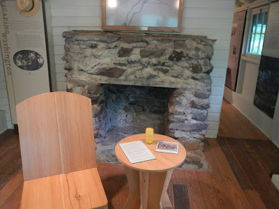
You can go into the Prime Minister's Cabin and see the displays.


I can only imagine how it must have felt to come up here and escape the pressures of the job.  The Press Corps were not allowed near the place and had to stay miles away.  The babbling streams are peaceful and soothing to the ears, eyes, and brain,

and to the feet.

On the hike out, there is a beautiful little waterfall and pool.  It was very tempting to go in there for a cool dip, but we decided to save that for a future hike.

After the hike, six of us went to the Big Meadows Wayside for a bit.  It was too tempting to not get the blackberry milkshake, so I did enjoy one.  We watched happy thru-hikers, sans packs, munching down on burgers, fries, and drinks.

We didn't really see wildlife on the hike to speak of, but on the drive out, we did spot this doe and her fawn along the Skyline Drive.

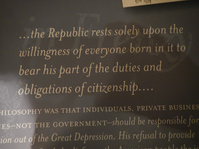
I really enjoyed this hike with a fine group of fellow hikers, and look forward to another one.  I am glad that the president and his wife enjoyed this little peace of heaven while they could, and am appreciative that we, the people can also enjoy it for as long as there is a United States.  Although this is not a political blog, I will leave us with some words of wisdom from the former president that we would each do well to reflect on:

Thursday, July 13, 2017

South River Falls in SNP

This is my last week before I click over into a new year, so I wanted to be sure to do some hiking, and I also set of a goal of 120,000 steps in the last eight days of becoming even older.  So Sunday, day two of the eight days, I returned to South River Falls in Shenandoah National Park.  It is about a 5.5 mile loop, but I added a little out and backs to it for a total of 7.7 miles.  Here is the location of this hike:

And here is my track, starting and ending at the circle, falls at the red star, and lunch spot on the Skyline Drive at the red arrow.  I also did that little hike on the Appalachian Trail for a bit just to add a mile or so.

The last time I hiked here, I came upon a large black bear that initially didn't want to yield the trail, but this time, no such spectacular wildlife sightings.  I did see three snakes, and I heard a number of birds, including hooded warbler, wood thrush, eastern wood pewee, oven bird, scarlet tanager, downy woodpecker, eastern towhee, Acadian flycatcher, red-eyed vireo, Carolina wren, and Carolina chickadee.

The hike starts from a picnic area, which had these signs prominently displayed.  It warned of problem bears in the area, which certainly became problems because of careless or ignorant humans.  Once a bear begins to associate humans with food, the best outcome will be the death of the bear.  The worst will be the death of a human AND the death of the bear.  Enjoy seeing a bear but never feed them, not even a cute little cub.


The path was generally nice and wide, and well maintained.  To get lost, you would have to be totally not paying attention.


After about a mile and a half, there is a viewpoint to the falls, deep in the forest.  It is about another mile to get to the base of the falls.

On the approach to the falls, I encountered the three snakes.  This one is a northern water snake, I believe, as was one of the others along with a ring-necked snake.

The falls plunge over 80 feet and were spectacular!


I lingered for a while admiring the waterfall, then headed back on the South River Falls Fire Road, a wide and pleasant path.  It was on this path that I saw the bear last year, so I stayed alert.  I also carried bear spray just in case, but I've never needed it.

I had lunch here on the Skyline Drive, and chatted with Canadian and German travelers....


... and ended my hike by going about 15 minutes north on the storied white blazed AT, then returning on the AT to the parking area.  Along the way, I met Woodbury, a through hiker heading for Maine.  He had no beard and I asked him about that.  It turned out that he started hiking in March from Georgia and took a 1.5 month break to attend to some family stuff.  The day I met him was his first day back on the trail!  He will reach Maine in October.