Tuesday, October 29, 2013

Buck Hollow Loop

Sunday being a gorgeous fall day, it seemed like a perfect time to head to the mountains for a hike.  So I asked a friend, Matt, if he wanted to go, and we headed up to Shenandoah National Park for the day.  It is hard to believe that it was my first time there in 2013!

There are over 500 miles of hiking trails in the park, including more than 100 miles of the Appalachian Trail.  Someday, it would be fun to hike all 500 of them, but Sunday, I picked out a six mile loop, Buck Ridge and Buck Hollow.  The map below shows this route.  We started and ended at the orange arrow on the lower left, and hiked counter-clockwise.  We headed out on the Buck Ridge Trail, which had a few level sections but was mostly downhill, and came back up through the long, uphill slog on the Buck Hollow Trail.
Here is the elevation profile (click for a better view).  We lost and gained about 2,100 feet.  Just before we reached the turn around point, where the Buck Ridge Trail intersected the Buck Hollow Trail, we descended about 500 feet in a quarter of a mile.  It was very steep there, and the trail crew had put in a seemingly endless series of log steps.  Both Matt and I have sore knees from running injuries, so it was difficult at times.
Before we started hiking, we stopped at an overlook and I got some photos of the foliage from on high,
as well as the hollow that we would descend into and the ascend from.
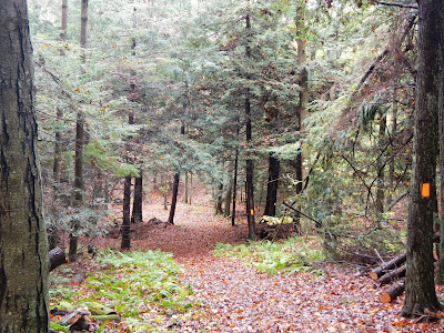
Then, we drove to the trail head and started hiking, beginning with gloves and jackets in the cool mountain air.  Before we had gone much more than a mile or two, jackets and gloves were in our packs.  Here is the Buck Ridge Trail near the start of the hike.
I love the flashes of red in the autumn woods.  They are not as common in Virginia as further north, but are a real treat to me when I find them.
Matt holds a huge maple leaf (I think) about a mile into our hike.
We had some partial views from Buck Ridge as we hiked.  This one looks across the hollow that we would ascend through later.
Everywhere we walked, the glories of Mother Nature were obvious.
Once we reached the junction of Buck Ridge Trail and Buck Hollow Trail, we stopped for lunch.  Matt's knees were killing him, and there was a place he could have hiked out to a road here for later pickup, but he said he would continue hiking.  It was at our lunch spot that a large yellow jacket crawled up my pant leg for some reason and stung my knee.  I am sure I presented quite the sight stripping off my trousers and trying to find out what it was that had caused me so much pain!  Eventually, I figured it out, but by then, my knee hurt a lot for the rest of the hike.

It was shortly after lunch that we encountered a beautiful stream, which was our companion for most of the uphill hike out.
Here is another shot of the stream, forming a little waterfall of sorts.  This happened over and over.  It was pretty, and the sound very pleasant.
We both were tired when we got back to the car, and marveled at the two guys we saw running the trail - four times!  That is 24 miles of running on rocky and fairly steep trails, with over 8,000 feet elevation gain and loss.  Hiking it once was enough exercise for me.

I had a great hike, and it was wonderful to return to Shenandoah National Park.  This was my eighth new hike of 2013, so I have two more to reach my goal.  Now that my half marathon is in the past, I hope I can make that happen.  Training for a race like that consumes a lot of time and energy! (But compared to running the trail today four times, a half marathon seems kind of wimpy!)

Saturday, October 26, 2013

Fall Friday Lunch Walk

Because of my work last weekend, the same work that required me to cancel my four day backpacking trip, my boss told me to take a couple of hours off yesterday, so I used the time to take a three hour lunch break and get in a downtown hike on a brisk but lovely fall day.  I decided to use my time to walk near the James River, heading first to Belle Isle - my favorite spot in the city - and from there through James River Park.

I walked a total of 7.25 miles, taking the route marked in purple below, and starting and ending at the star where my office is.  I crossed the river on footbridges, having not quite acquired the ability to walk on water!  You can see where I did the loop trail on Belle Isle as part of my walk.  The route marked in red is the Richmond Liberty Trail that I walked this past spring.
My first stop was for lunch on the rocks by the Hollywood Rapids.  Here is a panoramic view of the James at this point.
And here is a close-up of part of the rapids.
After (reluctantly) leaving the rapids and doing the Belle Isle loop, I headed over to the southside of the river and picked up a path through the city's James River Park.  A good many years back, this was supposedly a pretty rough spot, frequented by drug users and associated ilk, and a good place to get mugged or robbed at gunpoint.  The city has done a great job turning this into a much-loved urban park.  I eventually was on the Buttermilk Spring Trail, which I have hiked the length of before.
After a while, I ended up in Forest Hills Park, where I have never been.  I walked about a mile in the park, and can see that I will need to get back to explore some more.  Along the way, I ran into this fellow.
Is there any time of year better than fall?
I had to turn around at the lake in Forest Hill Park to get back to work, and once I left that park and re-entered the James River Park, I got back on the Buttermilk Spring Trail.  You can see how it got its name.  I wonder how many modern day Americans can imagine not having a refrigerator?
As I crossed the utility footbridge back to Belle Isle, still maybe 1.5 miles from work, I saw this great blue heron catching some rays along the quiet backwater portion of the James.  I had to zoom my camera to its digital maximum to get this close.

Sunday, October 20, 2013

Outer Loop Trail, Savage River Lodge

I should be getting up right about now, my fourth morning on the trail on my backpacking trip to "Virginia's Triple Crown," but instead, I am up early at home monitoring our project at work.  Ah well, some day I shall be retired and worrying about work stuff will be someone elses responsibility.  Right now, I will just feel grateful to have a job, and I will write about hiking instead of doing it.

After lunch a week ago, I decided to go for a third hike in the Savage River Lodge area.  For our morning hike, it had stopped raining and I thought that the weather was finally turning.  How wrong could I be!  When we left the restaurant at the lodge after lunch, it was raining steadily.  But I had come here to get in some hiking, and hike I would!  I put on my rain jacket and pants, shouldered my pack, and started out.  This time, I would be doing the longest trail in the area, the Outer Loop Trail.  Adding in the distance to get to the trail by starting out on Bodie's Trail near our cabin and ending back at our cabin, it should be just over four miles long.  Given that four miles is my minimum distance to count a new hike, I could then add Savage River to my list of new hikes, and Maryland to my list of states hiked in.

Let's start with the elevation profile.  A little bit of this hike covered distance I had returned over on my first hike the day before.  This would be the initial downhill portion on the elevation profile: 
To begin with, after leaving the road our cabin was on, I started back on the green blazed Bodie's trail.  If you look at the map posted on the account of my first hike (the orange blazed trail), this hike (including the beginning section on Bodie's trail) will be the one with track marked in red.
From there, I got on the red blazed Outer Loop Trail, which was very easy to follow and very well marked for about 95% of the distance.  I'll talk about the other 5% later.  This was the first trail that I hiked on at Savage River with many nice encounters with streams.  I think this one is called Mud Lick Stream.
Here is another view of the same stream a little later on.
I also liked this partridge berry on the ground near this stream.
You can see one of the red blazes of the trail here, and see how it easy it is to follow.
After crossing the road (there is a parking spot here for the state forest where you can leave a car and jump on the trail), I passed one of the few nice open areas, most of this trail being in thick forest:
From here, things got dicey for a while.  The trail kind of disappeared in thick undergrowth.  At this point, it was pouring, and the rain seemed to soak through my rain jacket, which is pretty old and probably needs to be water repellent treated or replaced.  I was completely soaked, and pushing through undergrowth, guessing where the trail was.  I even retraced my steps at the point shown below, as the "trail" was only about 18 inches wide at this point and climbed steeply over this stream.
But it was also at this point that I saw a faded red blaze, so I kept going, pushing through even more thick undergrowth.  Then suddenly, after less than a quarter mile, the trail opened up and there were plentiful red blazes again.  It remained that way for the rest of the way back.  Because it continued to pour and I was soaked, I shortcut about a third of a mile or so by taking the gray blazed trail (I forget its name) back to the cabin.  But I still got just over four miles in, and thus can check off another new hike this year, and add the great state of Maryland, my mother's birth state, to my list of states hiked in!

If someone wanted to come into this area for a day hike, I would drive in and park at the little state forest parking lot.  Then, I would head to the left and cross the road, picking up the red trail in the opposite direction that I hiked it (hiking the loop clockwise).  Follow the red blazes, and if you want, when you get to the green-blazed Bodie's trail, take this trail a short distance to the Savage River Lodge.  Have a nice lunch or a drink, then reverse your track back up Bodie's trail the red-blazed Outer Loop Trail, turning to the right to continue in a clockwise direction.  This will take you back to your car, with about a quarter mile of it being overgrown and difficult to follow (unless I just somehow got off the real trail for a little while - maybe coming back from that direction it is obvious, especially if it is not pouring).

This trail would also be great for cross country skiing , although that one overgrown area would be rough.  It is a beautiful little hike, with lots of interesting things along the way.  I would guess you might see wildlife (wear orange in deer hunting season) if it were not pouring rain.

Saturday, October 19, 2013

Bodie's Trail, Savage River Lodge

For the second hike up at Savage River Lodge, my wife and I walked the very pleasant "Bodie's Trail," marked in a magenta color on my trail map image here.  The actual trail, named after the lodge owner's beloved dog, Bodie, is blazed in green.  We incorporated a short loop of the Woodcock Trail into our walk, and since we ended up close to our cabin before completing the entire loop, we cut the walk short for a lunch break without completing the loop.  But you can get a good idea of the entire loop from looking at the map referenced above.

Here is the elevation profile, which might be useful for cross-country skiers.  Since we did not complete the entire loop, you can see that the starting and ending elevation are a little different:
We had barely started the walk when we saw this brilliantly colored bracket fungi on a tree.
You can see the green blaze marking Bodie's Trail very well here.  The trail is very well marked and extremely easy to follow.
Since a lot of this area is a state forest, trees have sometimes been planted in very straight rows, like these spruce.
Mother Nature is starting to show off with her colors up in the Maryland mountains.
I am always looking for interesting looking trees, and this one certainly qualifies.
Here is another view of fall's beauty:
We thought this bracket fungi was reminiscent of formations one sees in a cave.  Isn't it cool?
This walk was perhaps the only time we were at Savage River when it was not raining, other than a tiny bit of drizzle at the start.  We thought that the weather was finally turning, and that there would be decent hiking conditions after lunch last Sunday.  We could not have been more wrong!

Thursday, October 17, 2013

Orange Loop, Savage River Lodge

My first hike at Savage River Lodge in Maryland over the long weekend was a short one, about 2.5 miles, much of it in a steady drizzle.  There are 13 miles of trail around this picturesque lodge, mostly well marked with colors and signs.  I've indicated on the map below the three hikes I did in three different colors.  Today's hike is marked by the orange track at the north of the map.  More than half of it actually follows a trail with orange blazes.  The blaze colors are green - red (for about 50 feet) - orange - red - green.

 As a hiker, none of these hikes were difficult or had difficult elevations.  But on cross country skis, there could be some challenging parts, so I have included an elevation profile.  The profile starts on the orange track near the center, heads northeast, goes around the loop portion counter clockwise, and then returned to the lodge by way of the original portion.  Click on the profile for a better view.
This hike had lovely forest views, and lots of evergreens.
In addition, there were good numbers of hardwoods showing their colors.
Here is a mixture of softwoods and hardwoods along the trail.
As far as wildlife is concerned, I got a brief look at a wild turkey, and I heard a barred owl call its distinctive eight note call over a dozen times.  It is almost exactly a year since I last heard one of these owls up in the mountains of southwest Virginia.  Rain or not, I enjoyed my little hike last Saturday afternoon.

Wednesday, October 16, 2013

Savage River Lodge - Overview

Well, I finally got my last post written the other day about Cape May, NJ, identifying the mystery animal that I saw.  So it is time to start another little group of accounts, this one about the Savage River area of Maryland.

If I were tell you that there is a spot in Maryland that averages 160 inches of snow a year, would you believe me?  Well, it is apparently true.  There is a nice, rustic lodge in this area, and there is so much snow there that they are open for snowshoe use and cross-country (Nordic) skiing.  These are two things I have not done since I left Maine, where we used to get a lot of snow - but only about half of what Savage River gets.

We have wanted to check this place out for a long time and finally did, expecting typical lovely October weather.  What we got instead was four days (counting the five hour drive to and fro) of drizzle and rain.  But you know, one cannot control the weather, so I made the best of it.  It is  lovely area for hiking with 13 miles of trail on their property and on the adjoining Savage River State Forest, and there are lots of wildlife.

Where is this snowy place in Maryland?  Well, it is up in the "panhandle," just a few miles west of Frostburg.  I've marked it with a little purple star on the map below.  Pennsylvania is to the north, just over the Mason and Dixon line a few miles, and West Virginia is to the west and south.
 How did Savage River get it's name?  Sounds kind of scary, does it?  Well, some long time back, a group of men were lost in the area and ran out of food.  After a time, they decided to kill and eat the weakest of the bunch.  His name was Savage, and when another party came along and rescued them, Mr. Savage's life was spared.  So the named the River in his honor.  That's all pretty savage, isn't it?

I really liked this place.  It was lovely and relaxing.  And rainy.  Did I mention that it rained the whole time?  Well, rain or drizzle 95% of the time.  The other 5%, it was trying to figure out how to start raining again, and it always succeeded.  Fortunately, we took lots to read in our snug little cabin, which was in a stand of red spruce, replite with red squirrels and red-breasted nuthatches.
Inside, we had a little gas heated Franklin fireplace for warmth.  Plus, it added some nice ambiance.  The place was very comfortable.  There is no television, which some would hate for a few days, but I was fine.
In addition to the 16 cabins for guests, they are building yurts for the upcoming year, and those looked intriguing.  That is a big financial investment.

Here is the lodge itself, surrounded by fog.  It is a comfortable place to hang out it.  There is a great fireplace, as you might imagine, and a nice dining room with great food.  There also is a library (each cabin had its own selection of books as well).

I really liked the Savage River Lodge and hope to go back. The five hour drive from our home makes it difficult, of course, to go for even a three day weekend.

I took three hikes while there, plus visited Kentuck Knob in Pennsylvania, and will write about these in the upcoming days.

Friday, October 11, 2013

What Am I?

While exploring Cape May Point State Park a couple of weeks ago, I came on this bird sitting in a tree over the water.  It is one that I see from time to time, but never frequently, and not for a few years now.  This is the best look I have ever had at this usually very secretive bird, and I watched him for a good 15 minutes.  Put on your thinking cap, as this may not be an easy one.  The first time I saw one, it was hiding in a marsh up in Maine, making this incredible call.  I kept watching until I found it so I could figure out what the bird was that had such an unusual call.

In wetlands damp I'm always found
It's for my call that I'm renowned

My pattern's brownish and white streaks;
I have a sharp and spear-like beak

And with that beak I'll try to spear
Whatever creatures come too near

Be they frog, mouse, or yummy fish
To catch dinner is my fond wish

My color pattern helps me hide
Tall reeds is where I'm often spied

And so, how are you thus far fairin'?
You guess that I'm a stocky heron?

Now how can I describe my call
Which if you hear it should enthrall?

"Oong-ka-choonk" with pumping sound
Which loudly booms o'er marsh and ground

Not easy, is it?
Well, I threw
a lot of
facts in the
verse above
If you ever
heard one of
these stocky
herons then
you will get
this one.
Scroll
D
O
W
N
for the answer
and photos

Within your brain did the facts churn
To guess American bittern?

I've never before seen this bird when it wasn't hiding.  This one was just sitting up in a lovely flowering tree over the water, maybe catching the morning rays.  I really enjoyed that my day and his intersected for a little while.


I've only heard a bittern a few times.  I used to see them in Back Bay National Wildlife Refuge from time to time, and they were always very secretive.

Thursday, October 10, 2013

Higbee Beach WMA

I've been too busy lately with my Team in Training event, the Crawlin' Crab Half Marathon to complete my descriptions of my three Cape May, New Jersey hikes.  But I am finally catching up here, with a short account of my hike at Higbee Beach Wildlife Management Area on September 28.

Yes, there really is a beach there, on Delaware Bay.
The trails there are not well marked and often barely distinctive from game trails.  This one is typical, and some were much less distinct than this one was.  My brother-in-law was hiking with me, and I think he got a little nervous at times.  And I saw stars when I ducked to go under a fallen tree, but didn't duck far enough!  But we were never in danger of getting lost.
We ran into two young women with a dog and four very little kids, and they told us roughly how to find a lake.  With that information and my GPS, we headed towards the lake and found is, with high sand dunes all around like this.
It was a really pretty little lake, a gem so near a city.  I wonder how many people vacation in this area and have any idea that such a pretty little lake exists so close by?
 Panoramic view of the lake....
I had really hoped to see migratory birds and other wildlife here, but it was the middle of the afternoon, and other than an egret, there was no other wildlife visible.  We did see this cactus with fruits, which was pretty neat.  And we had another nice walk, maybe about 2.5 miles, in extreme southern New Jersey.