
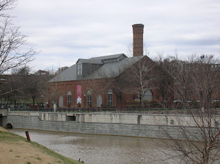
 From my office, I walked about a half mile to Brown's Island, a small island on the James. Here is a view of the former Tredegar Iron Works, now the Civil War visitor center.
 On Brown's Island is this nice statue, a monument to the African Americans who helped run commerce on the rivers and canals of Antebellum Virginia.
 Looking north and upriver from Brown's Island is Belle Island, former site of a prisoner of war camp in the Civil War and post-war industrial developments. Now it is a nice hiking spot and natural area. I did a prior hike here and also used it for a marathon training route last year.
 A little foot bridge extends into the river, and has quotes from people about the fall of Richmond in April, 1865. This one from President Lincoln is poignant, as he was assassinated less than two weeks later.
 I left Brown's Island and walked along the canal, reaching this point on the Canal Walk, with a green cross as a monument to Christopher Newport, discoverer of the future site of Richmond, in the background.
 Part of the flood wall starts here. Note the big watertight door that can be dogged shut in a flood to protect the downtown.
 This is part of a race in a lock connecting a couple of the old canals. There is amazing stone work in this section.
 Before the Civil War, slave Henry "Box" Brown had a white friend nail him into a box and ship him by rail to Philadelphia and freedom. This site along the canal is a monument to him and his courage to undertake this. The "box" is the exact size: 3 feet by 2 feet by 2 feet.
 Part of Richmond's canal walk as I looked back towards the 14th street bridge. I returned from the "Box" Brown monument to cross the river on that bridge.
 Old railway cars along the canal.
 From the 14th Street Bridge, one can see the great blue heron rookery in the distance - see the nests up in the trees behind the old abandoned bridge? I crossed the James on the 14th Street Bridge, also called the Mayo Bridge.
 Once I crossed the James, I prepared to climb up on the floodwall for the walk upriver. First, I saw this nice monument to diversity, acceptance, and inclusion at the base of the floodwall.
 Here is a view of the amazing rapids from the top of the floodwall. You can see why Chris Newport stopped at this point. His boats could go no further. These rapids are why Richmond exists here. In the distance is the Manchester Bridge, on which I walked back to the other side of Richmond towards the end of my hike.
 Here is the path along the top of the floodwall, looking north at the Manchester Bridge.
 View from the top of the floodwall looking back south (downriver) from where I had been a short time ago.
 View back to downtown Richmond, where I will return via the Manchester Bridge in the right of this photo.
 As I crossed the bridge, I had a nice view of the floodwall upon which I had so recently tred. Soon it would be back to the office, but with the memories and physical benefits of my nearly five mile leg stretcher.


Wow that was quite a walk you took during lunch. All nice photos and enjoyed them all. How nice you have such an interesting place to walk.
ReplyDeleteIt was a lot of fun, and a nice work break.
ReplyDelete