Last Sunday, my legs were sore from the prior day's 12 mile run, and I had other stuff to do, but I did find time for short hikes on two local Civil War battlefields. Something like one fourth of the battles in this terrible war were fought on Virginia's soil, so there is no shortage of these now peaceful places. However, a number of battlefields are threatened or have largely disappeared to development.


My hikes were primarily a chance to do some testing with my DeLorme PN-60 GPS that I am Beta testing. It is very impressive so far. I would love to take a month off and do nothing but hike and test this thing.
My first hike was on the Gaines Mill battlefield. The battle was fought in June 1862 as part of the Seven Days Battle. The USA won most of these battles but it was overall a strategic Confederate victory because the Union gave up on its attempt to capture Richmond and retreated. You can see with this map how close the USA Army got to the capital with both of these battles, just to the east-northeast of Richmond:

Gaines Mill was fought on open ground that is now mostly wooded with pretty forests. There is a stream running through it, and some steep slopes that soldiers had to charge up into musket fire. A trail goes through some of the battlefield, and I mapped where I hiked here with my GPS:

In the swale downhill from the trail, near the creek, I spotted a pretty whitetailed deer, who bolted before I could get a photo. The only other wildlife I saw on the hike were mosquitoes (plenty of them at points) and a bluebird.

At this point is a memorial to a brigade from Alabama. I wonder how it was for farmboys who had never been more than a few miles from home to be fighting and dying hundreds of miles from where they were born?

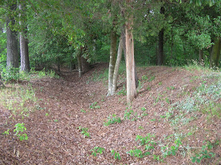
This old rifle pit certainly would have been deeper nearly 150 years ago, but it is still distinctive. At the time of the battle this would have been mostly fields.

The guns are now silent here, thank goodness!

The Battle of Cold Harbor was fought over much the same ground almost exactly two years later in June 1864. It was the last major battle in Grant's overland campaign against Lee, and was such a decisive Confederate victory that Grant abandoned the attempt to take Richmond directly and instead conducted a nearly 10 month siege against Petersburg that ultimately ended the war. My hike was on a tiny portion of this huge battlefield, where trenchlines once extended something like seven miles. Here is map of my one mile circuit hike produced by my GPS:

This battle was a huge mistake by the USA, and Grant recognized it later. Something like 7,000 men in his army fell in the first 20 minutes of Grant's final assault.

Here is part of the Confederate trench line, still pretty well preserved.

From this position, you can see the Confederate trenches with the field downhill from it, across which the Union Army had to attack.

The battlefield was mostly open (and devastated) farm land in 1864, but now this part of it is peaceful and pretty woodland.

This area is maintained in field to show what it would have looked like at the time of the battle.


No comments:
Post a Comment