Sunday, April 24, 2016

President Hoover's Rural Retreat

Before there was Camp David, there was Rapidan Camp, also called Camp Hoover.  This is the spot, now deep in Shenandoah National Park, where President Herbert Hoover built a retreat from the hot weather and simmering politics of Washington DC.  He and his wife Lou came here often, with the President's main passion of fishing fully in play in the beautiful spot where Laurel Prong and Mill Prong meet to form the Rapidan River.

Yesterday, I led a "group" hike here.  Well, "group" is a relative term.  Two other signed up, but one of them did not show.  So my group was two people - counting myself.  No matter, and no matter that the fog at the start was so thick we could  not see 100 feet, or that it rained on and off for the first two hours of the hike.  Spring time hiking in the mountains?  Good enough for me!

Here is the track for the hike to Rapidan Camp, where three of the original buildings still stand in this National Historic Site.  The circuit hike was nearly eight miles.  The orange arrow (upper left) shows the starting and ending point of the hike, the purple arrow shows the direction of hiking (counter-clockwise), and the red arrow shows the location of Camp Hoover.

We saw hardly any wildlife (a gray squirrel and a slate colored junco), but we heard some birds, including a pileated woodpecker, ovenbirds, and phoebes.  And we saw some wonderful wildflowers. At higher elevations, there was hardly any green yet, but there was plenty at the lower points on the hike.  This hike has no real views, but given the fog, it would not have mattered.

Here are some photos of the hike.  Here is the rest of my "group," Lina at the start of the hike into the fog.  Note the lack of leaves on the trees at 3,200 feet elevation.  Our highest point was over 3,800 feet on the summit of Hazeltop Mountain.

There was a virtual forest of mosses on this tree branch.

We saw lots of trilliums on the hike - so beautiful.


We also saw several large patches of may apples in the woods.


It's pretty clear that a black bear found tasty grubs in this stump.

At lower elevations, there is significant greening - "Primavera"

A couple road horses in to the camp.

This was the Hoover's home.  They called it the "Brown House," as opposed to the White House.  Yeah, I could live here!  What a gorgeous spot!

Here are some ferns in their fiddle head stage.

This building is known as the "Prime Minister's Cabin," because Prime Minister McDonald of Great Britain stayed here for a visit and for a discussion of naval treaties.

This is not the remains of a building, but is an outdoor fireplace where guests could gather in nice weather and enjoy a campfire.

Known as "The Creel," this cabin was a guest cottage.

On the hike out, up the Mill Prong Trail, we enjoyed looking at Big Rock Falls.  By the way, Camp Hoover could be done as an out and back hike of about four miles by coming down the Mill Prong Trail and returning on that trail back to Milam Gap.

Here is some more green - skunk cabbage in the woods.
 

What a fun hike - whether you are a big group, a group of two, or going solo, I recommend this hike if you like nature, history, and walking.  I'll be hiking near here in another week, and will be very interested to note the changes in greenery.

Tuesday, April 19, 2016

Short Evening Hike, and Heading Back

After Saturday's long day hike, and relaxing a bit, chatting with my campsite neighbors, it was cold and windy, and folks were hitting their sleeping bags, but it seemed too early to get in the tent, so I decided to hike over to Widgeon Point.  It was about three miles round trip, and I have indicated the route on the map below.  The purple circle on the left is my campsite, and the arrows show the track to the point (ignore the blue lines going north and south in the middle - they are track lines from other hikes).  The orange circle shows where campsites 1-3 are located, and the red circle is Widgeon Point.

Along the way, I went up to the campsites to see if John and Catherine were still up, and they were sitting at the picnic table at their site and chatting.  I wish I had taken a photo of John's hammock - it was pretty cool.  We talked for a while, then walked together out to the point near their campsites, which actually had a real bathroom!  The wind felt like it was going to simply carry the building away!

Then I headed to Widgeon Point, with Catherine coming along.  We enjoyed the beginning of the sunset for a bit, then headed back to our respective tent sites.  I listened to a great horned owl calling as I walked back.  I had heard the owl the prior evening when I returned from a short hike.

Here are a few photos from Widgeon Point.


I slept reasonably well, but woke several times as the wind buffeted my little tent.  When I got up for good it was cold - near freezing - so I made tea and a hot "meal in a bag."  I packed up and hit the trail to hike back to my car 6.5 miles away.  Since the route was the same as my day one hike, I didn't take many pictures, but here is one to show what a pretty day it was.

Despite the wind, I did see a number of birds on the way out, including a beautiful male northern shoveler, a harrier, and a pair of mature bald eagles flying together - the wildlife highlight of my three day hike!

I loved exploring False Cape, finally getting there to camp after over 20 years in Virginia.  I plan on returning, maybe in the fall!

Sunday, April 17, 2016

If You Don't Like the Weather, Wait Five Minutes

On the second day of my three day trip to False Cape State Park, I had planned on going hiking into the Wash Woods area.  This is an historical site to commemorate a place where there was once a community.  They even had a church.  So after a hearty breakfast, I joined the six hikers that I had met from Hampton Roads Hikers, and off we went.  It was fairly chilly, and quite windy.

Our hike was about 10.5 miles and covered a nice section of the park.  It was essentially an out and back.  This map shows our track.  We started at the visitor center, which is just north of the map.  At the southern part of the hike, there is a small loop.  Also, about halfway down, see the little spur that we walked heading southwest to the bay?  That is essentially where the other six campsites are located.  So if you wanted to camp there, you would have to carry in water at least 2-3 miles from the spigot near the visitor center.

As we hiked, the weather changed continually.  It would cycle through cold and windy to sunny and warm.  At one point, a squall came through and it snowed for a few moments.  I was continually adding and removing layers, including gloves and a winter knit hat.  Anytime we reached an open area, the wind was fierce!

Here are some pictures from the day of hiking, starting with one of the six people I met and hiked with from Hampton Roads Hikers - what a great group!


Do these look like stones?  We thought so, but upon checking, we found that each was a big ball of some kind of lichen.

Much of the path is essentially a woods road, very easy walking.

The winds were fierce this day.  Here some of the group looks at a map and several others relax.  Because of the wind, we did not see any meaningful wildlife.

Like every Virginia State Park that I have hiked in, the trail network is exceptionally well marked.

This is the "Blue Goose," which transports visitors from the Back Bay NWR to False Cape State Park for a brief visit.  I saw it again the next morning as I hiked out.

This is all that remains of a church that used to serve the once-upon-a-time community here.  It's kind of sad.  The bricks mark the church's approximate footprint.

Just yards from the church site is a little graveyard.

We climbed an observation tower and ate our lunches up there.  Over the flat terrain and the tree tops, we could see the ocean.

Know a good mechanic and body shop?  This car can be yours for a very reasonable price.

I believe that this is some kind of wild azalea.

Some of the group walk down the path through pine forest.

I really liked the budding red maple.  I can still remember, long ago, seeing ruffed grouse in early spring high in red maples feasting on the buds.

Our hike ended in mid-afternoon, and I relaxed at my camp for a while with a mug of hot tea as the wind whipped by.  I chatted with my fellow hikers for a bit, and we shared dinner together at one of their sites.  It had been a really good day, changeable weather being what it is.

Friday, April 15, 2016

Best Back Country Breakfast Ever!

There were a number of great things my recent False Cape State Park backpacking trip,  It was as flat as you can get, and I'd only have to carry my relatively heavy pack in and out, since I'd be setting up a base camp.  There would be drinkable water at a spigot, so I would not need a water filter.  Therefore, I carried a few things in my pack that I might not normally bring, and one of them was my little fry pan for my Jet Boil stove.  I'd bought the pan last year and had not yet used it.  Finally, the site provided a picnic table, a super luxury when one is backpacking.  (There also were his and her outhouses, with hand sanitizer, another nice plus).

It being cool, I packed in a couple of tablespoons of butter in my food bag.  I carried in some Hungry Jack pancake mix - you only need to add water - and some real maple syrup.  And I used my stove and fry pan to make pancakes for breakfast Saturday morning!  So yummy!

I could only make one pancake at a time, and I would eat it at the picnic table while making the next.  Because the stove burns so hot - it is called Jet Boil after all - it's best use is for boiling water rapidly.  But in this case, by experimenting and turning it down low, I was able to make some really good pancakes.  Being able to sit at a table with the stove just off to my side while having my plate in front of me made the process pretty easy.  I used some of the butter to lubricate the pan, and the rest went on the pancakes.  Here is a pancake in progress...


And here it is after flipping it.

The frosting on the cake came when Mike, the leader of the Hampton Roads Hikers group that was camping around me, came over to my site carrying a hard boiled egg!  "Here," he said.  "We are having duck eggs for breakfast, and I made you one."  It was still warm, and such a treat.  I've never had fresh eggs in the back country.  This was truly a breakfast that will be hard to top!

Thursday, April 14, 2016

False Cape Hike - First Day

I used to hike all the time in Back Bay Wildlife Refuge, getting to False Cape State Park a few times.  But it has been three years since I was there, and it felt good to get back.  My first day of the three day backpacking trip mainly involved just getting to the park.  From the parking lot at Little Island City Park, it was about a 6.5 mile hike to my campsite. I've marked my track in orange on the map below, with the orange arrow showing the location of my campsite, campsite #5.  The park has 12 campsites, and sites 1-6 have drinking water available by way of two taps.  The other six sites (which are a good two mile walk further south of the first six sites) have no drinkable water, and I doubt there is any good fresh water source on the barrier island that humans could drink.

Between April and October, one can hike through Back Bay on one of the two dike trails through the Wildlife Refuge.  In this case, it was the west dike trail that was open.  Most of the side trails were closed off to protect wildlife, so I didn't do any exploration along the way.  It was just a point to point hike, carrying my pack, and getting to my campsite.  I did watch for wildlife along the way in the wetland environment, and did see a fair variety of birds and many, many turtles.  A complete list of critters seen during my hike can be viewed here.  Weather-wise, last Friday was by far the pick of the three days - sunny, no wind, and temperature topping out near 60 F. I saw a number of day hikers in BBNWR.

Here are some photos from my first day in Back Bay National Wildlife Refuge and False Cape State Park.  On the hike in along the refuge road, there is an osprey nest with a pair of these fish hawks setting up housekeeping.


Turtles, probably yellow bellied sliders, catching some rays to elevate their body temperature.

A lot of the walk through the refuge involved walking along the gravel road with water just to the side, so there was always the chance to see wetland oriented wildlife.

Here is one yellow bellied slider that didn't mind me being fairly close.  Usually, they dive if one gets within 60 feet.

Some of the pathway went away from water and through a coastal forest.

Wild azaleas, I believe.

American coots swimming at the boundary to False Cape State Park.

Upon reaching the entrance to the park.

I got my campsite set up right away down near the ocean....

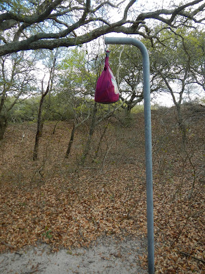
hung my food bag (no bears but raccoons, opossums, and foxes) ...

and walked through the dunes.....

to explore the beach a little bit.  This is the most remote beach in Virginia, and one of the most remote and pristine on the east coast.  It is wonderful to have such a beach preserved for public and wildlife use.

After a delicious dinner of curry in a hurry, I walked and explored a few miles, and saw many animals.  I got back to my camp, looked at stars (no ambient light makes for great viewing), read a bit, and then slept like a log during the fairly cool (for April) night.