For most of the hike, I saw only two people - a couple I passed descending towards the stream. I saw a few others on the ridge hike out of the watershed, and then a number of hikers and backpackers on the Appalachian Trail over the last mile. Here is a map of the route, as well as an elevation profile. The first part of the hike is a steady decline into the watershed, the middle third is a moderate climb back out - gaining 600 feet in the first mile after the stream - and the final part is ridge hiking with minor up and downs.
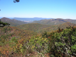
 Near the start of the hike, there is an overlook on the Skyline Drive where one can see much of the Big Run watershed, where I will be descending into shortly.
This hike goes through lovely forest, and is very tranquil and soothing.

Mother Nature likes to change the carpets and her decorating scheme this time every year:


Big Run may not look like much, but it was tricky to cross without getting my feet wet. Without my hiking stick - and trekking poles would have been better - I think wet boots would have been the result. I ate lunch here, my typical PB&J:

At this point, I've gained 1,000 feet or so from my luncheon spot at Big Run, and started to get some partial views again.

I think this is sassafras, decked out in orange for Halloween.

The last mile or so of the hike is on the Appalachian Trail, as I passed by this dramatic rocky area.

Here is my final vista of the hike, the eastern view from the Doyle River Overlook on the Skyline Drive as the Appalachian Trail passes by. My beautiful hike is nearly over.


Awesome photos. Such a beautiful time of year!!
ReplyDeleteIt sure is, Karen. Glad you enjoyed the photos. Art
ReplyDelete