Friday, August 14 - the last day of
AMC August Camp - dawned, and I found that I was again signed up for my first choice hike - the Obsidian Trail. This hike had been offered earlier in the week and folks really liked it. It is 12 miles long and thus considered to be an "A" hike, but the leader was Eva, who led my hike the day before to
Tam McArthur Ridge. She assured everyone that while we would be moving along, we would not be on a rapid pace and that everyone would be able to keep up.
This ended up being my second favorite hike, and I have to wonder if it would have been my favorite if the weather had been more clear. It goes through some very scenic country, and while it didn't rain, it was overcast and very cool without some of the long vistas that we had on all of the other days. As I said, the hike was 12 miles long and of a lollipop orientation - an out and back section of about four miles each way with a four mile loop. Here is a map of the track. We started and ended at the upper left, and we did the loop portion of the lollipop counter clockwise as the arrows indicate.
You'll note that the trail climbs steadily all the way up and for the first part of the loop, then it more or less descends all the way back to the trailhead. The total elevation gain and loss was about 1,800 feet, and it was never extremely steep as were some of the other trails this week. It was a good workout without being totally nuts.
Here, we've zoomed out a good bit so you can get an idea of the terrain. Note the peaks to the east - the three Sisters, some of the tallest and most rugged peaks in Oregon. North Sister is almost exactly due east of the loop portion of our hike.
We had a really good group on this hike, just as on all of the others. There were 11 of us, at many different paces - a couple of speed burners, some moderate but steady folks, and some a little slower. But even those like me who like to look at things and take photographs never really felt rushed. The speed burners waited at any major trail junction for everyone to catch up, and our leader did a good job of making sure everyone was together.
This hike had it all (other than the big vistas, and I think those were hidden in the weather). We started in beautiful forests, hiked past rugged volcanic areas and pumice, trekked through open meadows, crossed streams, had lunch by a waterfall, and even saw a couple of tarns. And that doesn't include all of the amazing obsidian! For wildlife, we saw a pretty cool marmot, which I'd only seen few times before in my life. It was a marvelous hike, and I am really glad that I didn't take the white water rafting option on the last day as I nearly did. That evening, I turned an account of the day into verse for the August Camp Talent Show: "
Ode to Obsidian Trail."
One of the highpoints was seeing the obsidian - black volcanic glass. In places, it was everywhere. And I found a number of pieces that look like they had been shaped into tools by peoples long ago, like scrapers or spear heads. I really wanted to bring some home, but we were all told that it was off limits to take any from this place. So I captured some photos of it, and memories.
Our hike started in a lovely forest, and climbed moderately but steadily uphill. This hike was the only one of the week where I wore layers - it was that chilly at times.
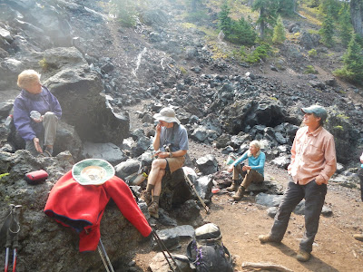
About three miles in, we took a break at the start of volcanic area. The remains of volcanic activity was everywhere through here.
Can you find this cliff on the topo map showing the hike's track? Hint - it is south of the "stick" part of the lollipop, but fairly close to the loop portion of the hike.
Just left of center you can see a couple of hikers picking their way across a lava field.
This hike had several lovely meadows, like this one.
I think this was the first hike all week that we crossed a stream, so it was pretty exciting. I was beginning to wonder if Oregon even had streams!
Part of the "lollipop" portion of the hike involved me hiking on the PCT for the second time ever.
Lovely Obsidian Falls ended up being a great spot to have lunch near.
Just above Obsidian Falls, we found an ideal lunch spot.
We saw two of these tarns on the loop portion of the hike. They were very cool!
Some of the landscape was almost bleak at times.
I wish I knew more about geology. I'd like to know the story of this amazing boulder!
Like a shepherd looking for a lost sheep, hike leader Eva searches for a straggling hiker.
Eva told me that this was bear grass post-bloom. It was about three feet tall, and when it is in bloom, it has white flowers.
This was just a fabulous hike. Everyone enjoyed it. And later, the hike gave me grist to create an entry in the Camp Follies that night - the end of week camper talent show!


