Saturday, December 8, 2018

Let it Snow!

After hiking solo in Shenandoah National Park on Monday, I was ready for a group hike, and joined the Old Dominion Appalachian Trail Club Wednesday to hike in Bear Creek Lake State Park.  Sorry, no bears, unlike my Monday hiking adventure.  As we gathered at the meeting spot southwest of Richmond, we noted a few snow flakes drifting along.  And as we drove along, we soon were in a steady snowfall.  By the time we arrived at the park 45 minutes later, snow covered everything, and it was still coming down.  It was quite beautiful.

My inReach is not creating tracks correctly for some reason, but here is the location of the park (orange circle) west of Richmond:

We did two different loops - a morning loop of 4.8 miles, then we ate lunch, and then a 1.8 mile afternoon loop.  We mainly walked through deciduous forest, with some water views.  The snow was beautiful.


Our group of a dozen really enjoyed our hikes.


Having the snow turned what would have been a fairly routine hike into a winter wonderland.  I really enjoyed hiking here.


About an hour after starting our hike, the snow had stopped and even seemed to be melting a bit.

After a nice trail lunch under a park shelter - chilly but at least dry - we started the afternoon hike.  By that time, most of the snow had totally melted.  We walked by the spillway of the dam holding Bear Creek Lake back, then the lakes itself.  There were some nice campsites along the lake shore.


We also admired the work of the Civilian Conservation Corps and Work Progress Administration from the 1930's.  They actually built a lot of the infrastructure of the first six Virginia State Parks.


I really enjoyed hiking here, and will definitely get back here for more trips.

Thursday, December 6, 2018

Two Shenandoah Hikes

I've done a fair amount of hiking since August, but was amazed to realize that I had not hiked in Shenandoah National Park since August 4!  Time to rectify that, and add a few miles to my "SNP 500" quest, so I hiked a couple areas that I had never been to.  The weather was cool but not cold, and the trails were clear.  The southern part of the park has been hammered by ice and wind storms, the Skyline Drive there was closed, and trees are down all over, but the central part of the park is fine right now.  Here is where I hiked:

The blue arrow points to the Skyline Drive in the central third of the park.  I entered at Route 33 (Swift Run Gap), and did a section of the Appalachian Trail and the Saddleback Mountain Trail (red circle) and a trail called the Meadows School Trail (blue circle).  The first hike was about 8 miles total, and the latter was 1.5 miles each way for a total of 3 miles.  My SNP 500 goal is now below 300 miles to go.  Unfortunately, my inReach is not producing a clear track map right now for some reason, so I am not showing the tracks for the hikes - they are inaccurate.

The trees are now totally bare.  This is the Appalachian Trail near Swift Run Gap.  Along the hike, I saw a pileated woodpecker and a white-breasted nuthatch.  Other than that, there was little wildlife to be seen or heard for most of the hike.

One thing I like about this time of the year is that you can see a long way through the woods, and even distant views.

I hiked to Route 33 at Swift Run Gap, then turned around.  It was a pretty easy hike, maybe losing and gaining about 700 feet over about four miles each way.

The Saddleback Mountain Trail leaves the AT and runs east of that mountain.  I ran into two women doing a day hike in this area, but they were the only people I saw over more than 11 miles of hiking this past Monday.

A short distance before joining the AT again, I came on this locked shelter.  The Potomac Appalachian Trail Club uses this to camp out when doing trail maintenance in this area.

The shelter is locked but I saw no harm in having hot chocolate and lunch here.  I got water from the spring, got out my Jetboil stove, and made a nice, hot drink.  Nothing like hot chocolate on a chilly day up in the mountains.  I saw a deer moving through the forest, and shortly after I started hiking again, two nice does ran right across the trail in front of me.  They were too quick for me to snag a photo, but that was okay, because an even more interesting wildlife encounter was ahead.

After getting back to the car at the South River Falls Picnic Area, I headed north on the Skyline Drive for about 5-6 miles for the next hike.  Ahead on the road, I saw a black animal in the middle of the road.  No doubt what it was, so I slowed down - I always go the speed limit of 35 in the park so I am less likely to kill an animal, but I see lots of people doing 50-55 - and got my camera ready.  As I pulled up, the small bear, which appeared to be a yearling, left the road and climbed up on the stone wall along the side.  It looked right at me!

Then, it turned and jumped off the wall on the other side.  It was small enough that I couldn't see it at that point.

The Meadows School Trail really doesn't have anything remarkable to recommend hiking it, other than I have to hike every trail and fire road in the park to earn my patch, so it seemed like a good day to just check this trail off the list.  It was 1.5 miles downhill about 900 feet, then 1.5 miles back uphill to the car.  Nothing special, other than any day we are healthy and alive, and out in the mountains is special.

This trail is not super-well maintained.  Note the deep ruts from storm runoff.  As a footnote, I brought my river shoes today and had no problem rock-hopping the few streams that I encountered, unlike my other recent hikes here where I was always having to wade across something, usually without my river shoes.

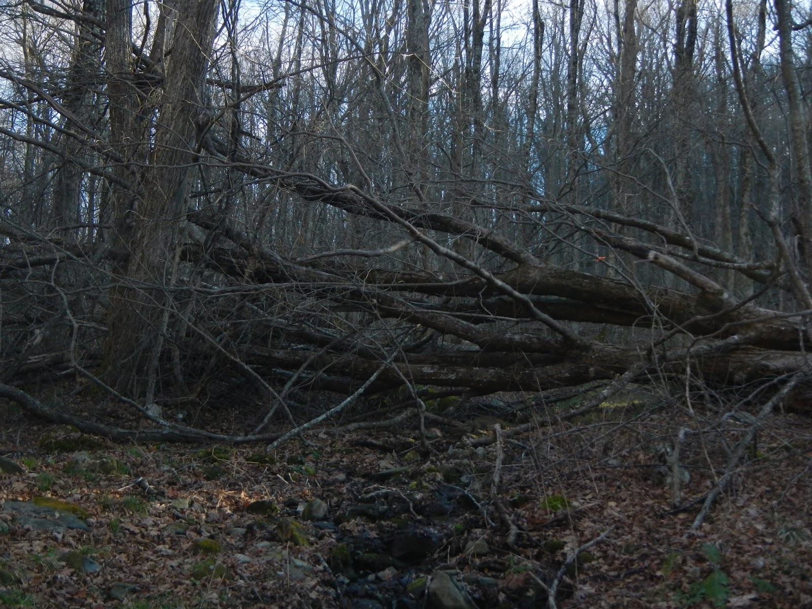
This large tree blocked the trail.  I made my way around it, as going over it would have been difficult.

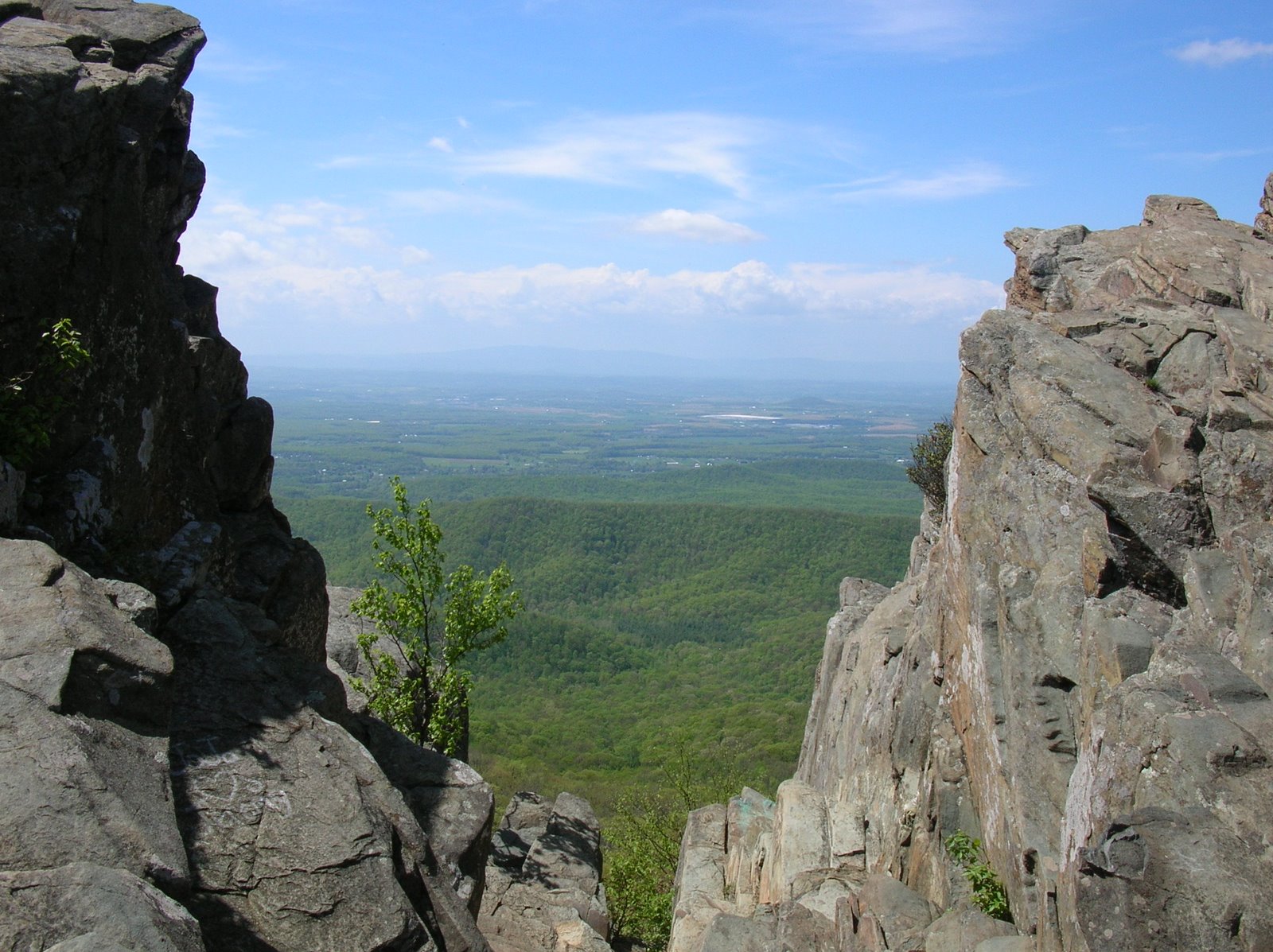
Back on the Skyline Drive, I paused to admire the view of the Shenandoah Valley before heading for home.

It felt great to be back in Shenandoah National Park again.  This is likely my last hike of the year here.

Wednesday, November 28, 2018

Lynn Ditch in the Great Dismal Swamp

Yay!  I've now caught up the accounts of my latest four hikes  Unlike the Sky Meadows hike, this one was really flat.  The goal was to lead a group hike to Lake Drummond in the Great Dismal Swamp, with four of us riding down together and the other two joining us there.  Unfortunately, when we got there, the gate to the trail was closed, with a sign saying that the Washington Ditch Trail was closed through February.  The other two were not there and didn't respond to calls or emails, so after about 20 minutes, we drove to the Jericho Ditch / Lynn Ditch Trailhead and hiked from there.  We hiked due south in a pretty straight line, reached the Washington Ditch Trail in about 5.5 miles, ate lunch (and got a great picture of a bobcat), and hiked back.  This was on "Black Friday."  REI had suggested opting out of shopping and getting outside, and that is what we did.  I won't call this hike boring because you are always looking for animals and such, but it not an exciting hike terrain-wise.

Here is the track, topographic map style and satellite image:


The word "swamp" conjures up a foreboding image in lots of people's mind - dark waters, insects, soggy ground.  For sure, there are lots of wet areas here.

But lots of the Great Dismal Swamp has been drained and converted to farmland or development.  And other sections have been drained so that pretty dry paths cut through the swamp.  Along the pathways are generally a wetland area, or "ditch", that has slowly flowing water.  We walked on the Lynn Ditch Trail, which connects the Jericho and Washington Ditch Trails.

We saw very little wildlife along the walk, and the neatest thing was a green heron that hung out near us for a while.  We also saw a belted kingfisher as it rattled along.  And we saw this poor little guy, which I think is a short-tailed shrew.

Here is another view of the Lynn Ditch Trail, which looks as straight as an arrow.  I continually scanned ahead with my binoculars hoping to see a black bear.

We saw lots of bear scat, like this, but no bears.  We literally could have walked within 20 feet of one and never see it, though - the vegetation away from the trails is that thick here.

Hey, I told you that we got a good picture of a bobcat?  Well, here it is, ha, ha!  The keys were actually in it!  The trail ahead was the Washington Ditch Trail, my original goal for the hike.

Our hike back was exactly the way we came.  We went a bit faster, but I did take note of a little fall color.  Actually, on the drive out of Suffolk, we all saw some of the most beautiful color we had seen all year!


Remember the other two, the couple that was going to meet us at the trail head?  Well, for starters, they left their mobile phone home by mistake.  But they arrived at the gate to the trail head about 10 minutes ahead of us, and the gate opened!  They drove in, waited for us, gave up, and hiked to Lake Drummond just the two of them.  The gate did not open for us, and the sign was pretty clear that the trail was closed.  Ah, well!  A good hike was had by all regardless.

Monday, November 26, 2018

Hiking in Sky Meadows

Two+ weeks ago, I led a hike for the Old Dominion Appalachian Trail Club to Sky Meadows State Park.  The weather was chilly but crystal clear, with lots of wind at times.  I'd been there once before, and recommend this park highly.  It is beautiful, has some easy and challenging hikes, some historical sites, and a hike-in campground.  Despite the cold weather, it was a very popular day to be there.

Here is the location of the park (orange circle) in northwest Virginia, not far from where Virginia, Maryland, and West Virginia all come together.

Here is the track of the hike, starting and ending at the red star, and moving in a clockwise direction for just over seven miles.  We covered open fields, thick woods, and steep mountains.

By the day of our hike, November 10, there was very little fall foliage left in that part of the state.  I've been out on trails a lot, but have somehow managed to miss the great foliage that happens each fall.  Here is the rest of my hiking crew.  Can you tell that is was cold?

One thing that I liked about this hike was the many miles through open country with nice views.

This white-tailed doe had very little concern as our group hiked past her.

The Blue Ridge doesn't look very blue this time of year.

Some of the group on the trail...

I liked the starkness of these trees against the blue sky.

Once we hiked up the mountains and covered a mile or so on the Appalachian Trail, we headed downhill and had some wonderful views of the Piedmont.  You can see how the park got its name, as we crossed these high meadows surrounded by the sky.


I'd like to return here and maybe snag a few back country campsites for a group, set up camp as a base, and explore the many trails.  Sound good?

Sunday, November 25, 2018

Cold Harbor Battlefield

A couple of days after the hike on the Virginia Capital Trail, the same group did a short 4 mile hike at the Cold Harbor Battlefield.  I've hiked there many times, and hesitated to publish another account, but decided to since it was with a group.  This hike was on October 31.

Cold Harbor was the scene of a horrific 12 day battle in June 1864.  It is a peaceable place now, and makes for a wonderful place to walk and commune with nature.  Here are a few photos from the hike.

We had a pretty good sized group, about 20 people, on the hike.  Here, a few of the group walk past an artillery piece.


At the time of the battle, most of the land was open like this.  Thousands of US soldiers attacked very well defended Confederate positions.  In one such attack, there were something like 7,000 Union casualties in about 20 minutes.

We stopped at about 10 historical markers that gave an account of the battle.  One of the group would read the placard to the rest of the group.  Here, a bridge was built to span original trench lines in an attempt to preserve them.

What was a bloody and terrible place in 1864 is now peaceful and serene, with natural beauty.  Most of the land is heavily forested.


There was a little pond along the way.  On prior walks, I saw lots of frogs here.

After the hike, I walked about a half mile to the national cemetery.  The men buried here, mostly dead soldiers killed in the battle and often unidentified, gave their lives for their country a long way from home.  It is important to remember their suffering and sacrifice.