Monday, May 20, 2019

North on the Appalachian Trail

Most of my hikes are loops or out and backs, but with a large enough group and a few cars, we had the opportunity last Saturday to do a straight shot up the AT.  The hike was with the Old Dominion Appalachian Trail Club, and we hiked north from the South River Falls Picnic Area to Milam Gap, where we left a couple of cars to shuttle everyone back to the starting point.  I'll be leading Road Scholar hikes in that area in about a month, and wanted to check out one of the trails so I'd know in advance what it was like.  However, the Road Scholar hike will start at Lewis Mountain and go to Milam Gap, and is several miles shorter than the one we did Saturday.  It was also a good chance to hang out with trail friends old and new, and see more of the spectacular wildflowers in the park, like these trillium.


Here is the elevation profile for the hike, which was 11.8 miles long, including two side excursions.  There were four significant climbs along the way, and plenty of shorter climbs, so I would estimate that we gained 1,900 - 2,000 feet during the hike.  I am not in the shape I was in October, the day was warm, and I was feeling it as I hiked the final ascent up Hazeltop Mountain.  But a couple of snails that blew by me on that stretch gave me encouraging words, and I made it.

We started at the red arrow and ended at the pink arrow.

Here is the track for the hike, heading north.  It's a straight shot up the AT.

This track shows more details of our little side trips to Lewis Mountain (black arrow) and Bear Fence Mountain (red arrow).

We had ten people on this hike.  Here are nine of them....

and here is the 10th, checking our map at the start of the hike.  You can see how I got at least part of my trail name, Grey Ghost.

Most of this hike, you are in the forest, following the white blazes,


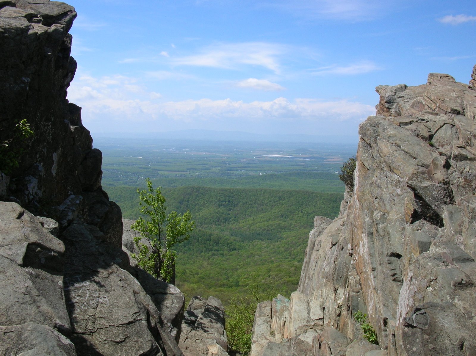
but now and then, we had some partial views.


Most of the group made the short and steep climb up to the great views of Bear Fence Mountain.  I was tired and had been up there before.  I also had forgotten that I could have gone up there without doing the full rock scramble.  It's a place that I will probably lead the Road Scholar hikers, though.

Along the way, the wildflowers were pretty spectacular, especially the trillium and wild geranium:


Among others, we saw bristly buttercup:

Virginia spiderwort:

and golden ragwort:

Also, a lady we met on the trail pointed out this flower that she called little brown jug.  You can see that the flower is brown and is under the leaves almost on the ground.  I've since learned that it is Canadian wild ginger.


I really enjoyed this hike.  With the warm weather, a nice lunch break near Lewis Mountain, the side hikes, and the car shuttle, it took longer than I expected.  We got to the park about 9AM and didn't leave until about 5PM.  I was tired for the drive home, but felt blessed to have spent the day in a beautiful place with a great group of fellow hikers.

Thursday, May 16, 2019

Revisiting a Favorite Trail

Do you have a piece of music that you love, one that you can listen to over and over, and never tire of it?  I'm not talking about a short song, but something with some length and depth to it that makes you want to concentrate, listen, and immerse yourself in the piece?  Something like Beethoven's Sixth ("Pastoral") Symphony or Mozart's 20th Piano Concerto in D Minor, perhaps?  Well, that is kind of how it was for me yesterday, hiking the Doyle's River Falls - Jones Run Trail yet again in Shenandoah National Park.  No matter how often I hike this trail, I don't tire of it. There is always something to see.  It always is peaceful.  And when the water is really flowing, like it was here at Big Falls on Jones Run, it's even more spectacular.


I hiked with a group of 18 (plus 3 of the four-legged variety).  There are two possible tracks, one of 6.5 miles and one of 8.5 miles.  I did the latter, and the track is shown here, starting and ending at the yellow circle and hiking clockwise.  I've always hiked counter-clockwise before, and enjoyed the change.  There is close to 2,000 feet elevation loss and gain on this hike.  Most of the gain is the final 1,300 foot climb out of the bottom of the Jones Run valley.

Here is the group at the start of the hike.  You've heard of a "Three dog night?"  Well, this was a "three dog hike!"

The first part of the hike is the "green tunnel" of the Appalachian Trail.  It's amazing how much more green it is than even just over two weeks ago on my Powell Mountain hike.

Our big group split into two smaller groups.  A group of 8 (plus the three dogs) took the shorter option.  The other 10 of us, shown here (with me taking the photo), split off and took the longer track.  In a bit, we further divided into a group of 4 faster hikers and the other six of us.  I am never gonna to be caught hiking in the fast group.

There is only one view on the hike, looking to the east.  Here it is.

After some more hiking along the AT, we got on to the Doyle's River Falls Trail, and started descending to the river.  Then, the hits started coming:


Upper Doyle's River Falls:

My group taking a break and enjoying the upper falls.

The upper part of the Upper Doyle's River Falls.  See the rocky edge between the upper and lower portion?  A couple came from the left and tried to cross there - very risky on the slippery rocks.  The man made it okay, but his companion slipped and fell and was fortunate not to get hurt.  She assured us that she was fine.

Lower Doyle's River Falls...


Here is Randy, one of our hike leaders, at a beautiful chute coming out of some rocks in the Doyle's River.

Hiking towards Big Falls on the Jones River, there are two massive yellow poplars.  You can get an idea of their size from this photo with two of the group.

As we climbed, the Jones River got more and more lovely,

until we reached the spectacular Big Falls.


At the top of Big Falls, looking down into the chasm...


The hits just kept coming,

but eventually, we climbed out of the river zone and were nearly back to the cars.  Beer and food at Blue Mountain Brewery awaited us.

I try to make note of the wildlife encountered.  Our group saw a large snake, but it was scared away before I saw it.  The other group saw a box turtle.  And while it's not possible to do real birding while hiking with a group. I did take note of the following birds at the least (I'm sure I forgot some, and there were some that I couldn't identify): eastern wood-pewee, great crested flycatcher, red-eyed vireo, ovenbird, black-and-white warbler, hooded warbler, black-throated green warbler, northern parula, scarlet tanager, tufted titmouse, and Acadian flycatcher.

Thanks to Leslie and Randy for leading such a great hike.  This was my second time hiking with this group, and it won't be my last.

Thursday, May 2, 2019

Mountain Wildflowers

If I weren't working on the Shenandoah National Park 500 (hike every trail in SNP, with nearly 300 miles to go), I might not have bothered hiking the Powell Mountain Trail Monday.  Given all of the wildflowers that I saw, like these golden ragworts, it would have been my loss.

It was a lovely and pretty well maintained trail.  Even though I brought my water shoes, there was only one tiny stream to cross and no chance of wet feet.  If I'd left 'em behind, of course there would have been a raging torrent to wade across!

Here is the track of the hike, starting and ending at the Hazeltop Vista on the Skyline Drive, hiking over Powell Mountain and moving 3.6 miles to the west (white) arrow, then turning around and hiking back (yellow arrow).  The hike starts at 3,300 feet and turns around at about 1.450 feet, so the hike back is a lot of uphill and both directions are good workouts.  I didn't see a single person the entire hike.

The highlights of the hike were the wildflowers - I recorded 20 species on iNaturalist - but I also saw a few salamanders and heard many birds.  I did periodic bird censuses and recorded the following 18 species: American robin, eastern phoebe, red-eyed vireo, ovenbird, wood thrush, blue jay, great-crested flycatcher, pileated woodpecker, black and white warbler, red-bellied woodpecker, tufted titmouse, barred owl, downy woodpecker, hooded warbler, grey catbird, Carolina wren, eastern towhee, and white-breasted nuthatch.

The very start of the hike had nice views over to the Shenandoah Valley, but after a few hundred feet of hiking, I was in the forest and the views were over.  So I concentrated on the small things - birds and wildflowers.

The woods at higher elevations are beginning to show signs of spring.

 As I descended, the forest became more leafed out.  Here is a flowering dogwood with mountain in the distance.

There were only two places where there were trees down across the trail.  This was the worst one.


Here, a young hemlock has managed to evade the wooly adelgid.

This was the turn around point, the trail having reached a gravel road outside the park boundary, nearly 1,900 feet below the starting and ending point in elevation.

My remaining photos are some of the wildflowers that I encountered...

Bird's foot violets:

Carolina vetch:

Common blue violet:

Common hawthorn:

Cut leaved toothwart:

Dwarf cinquefoil:

Flowering dogwood:

Large-flowered trillium:

Mountain azalea:

Wild geranium:

Wild pink:

I really enjoyed my time Monday hiking in the Blue Ridge Mountains, and look forward to the next time.  Although there are not any grand views along this trail, the wildflowers and ability to communicate with nature while getting some good aerobic exercise make this a wonderful hike.