Showing posts with label Piedmont. Show all posts

Thursday, February 21, 2019

Walnut Creek Park

If you want a taste of the mountains without the steeper and longer climbs, and with a shorter drive from Richmond, Walnut Creek Park is a good bet.  I went there on January 26 with the Old Dominion Appalachian Trail Club.  It's about a 20 minute drive south of Charlottesville, still in the Piedmont, but getting quite close to the mountain hiking experience.  Our group of about 15 took two hikes together for a total of nine miles, one of about 6.8 miles and the other of 2.4 miles.  In between the hikes, we hunkered down in a covered picnic shelter by the lake for lunch.

Here are some photos from the hikes in Walnut Creek Park, starting with the reservoir:


Some of the group moves down the trail.

 This once was part of someone's home.  Now, it is an easy drive to a big town with a huge university, but at the time of this cabin, it would have been near wilderness and very remote.  No grocery stores for these folks!

This is the dam that creates the reservoir, and the spillway into the creek.  During this hike, we reached several creeks that were too high to cross without getting soaked, so the hike leader altered the route - which included hiking along a road for a bit (but it beat getting soaked boots!)

A few of the lake from near the end of the first hike.

The second hike was short but very scenic - it really gave me the feeling of being in the mountains.  The streams were beautiful!  There was also another old cabin site.  I wonder what these mountain peoples' lives were like?  What happened to them?

Doesn't this look like a mountain stream?

Some of the group left after the first hike.  I think we had about 10 for the afternoon hike, and here, some of them move along the trail.

This was a lovely stream to walk along.

I enjoyed my not-in-the-mountains hike that felt like it was in the mountains.  I highly recommend walking here.

Tuesday, October 23, 2018

Horsing Around in Goochland County

After my 32+ mile backpacking trip to Pennsylvania, I wanted to go for a short and relaxing hike, and an Old Dominion Appalachian Trail Club hike near here last week exactly fit the bill.  Two club members, Jack and Pat, sponsored a 4 mile hike and cookout at their home in the country last Wednesday.  We had beautiful weather for the day, and their property is in a lovely horse-oriented community in Goochland County.  Along the way, I took a few photos.

Here was where we hiked, starting and ending at the red circle:

This was maybe the biggest club hike I ever went on, with lots of people out there.  The beautiful weather and burgers and dogs surely didn't hurt.  Lots of folks out on the trail that day.

We hiked through forests,

horse farms, such as the one occupied by these mules,

and past open fields.

There were also some ponds, like this one coated in green duckweed.

I particularly liked these miniature horses.

Well, most of my hikes are a bit more challenging than this one, but they rarely end with a great cookout and hiker fellowship.  I had a great day!

Monday, October 12, 2015

Mushrooms in the Forest

After a couple of weeks of being unable to get out on a hike, I was looking forward to joining a group from ODATC for a hike in the Appomattox - Buckingham State Forest today.  I was looking forward to it so much that I arrived at the meeting point five minutes early, taking the exit for the huge shopping center, and eagerly looking ahead for Joanne Fabrics, the meeting spot.  The infallible map inside my flawless male brain knew exactly where Joanne's was located, except someone apparently moved the store.  Like, they moved it pretty far.  So I spent 15 minutes driving all over looking for it every which way but in the right place when I suddenly spotted the store across the way and got there just before everyone headed out!

What a great day for a hike!  The weather was perfect and the leaves are just starting to turn.  While we saw no wildlife or great scenery - the view was quintessential central Virginia forest - we did see a lot of interesting mushrooms.  I think that all eight of us enjoyed the hike a lot.  This was the longest hike I've done since the Obsidian Trail in Oregon almost exactly two months ago.

The trails covered somewhere between 10.6 (what my inReach tracked) and 12 (the hike description) miles, mostly level woods roads, with one amazingly steep section.  Here is a view of the track, which we hiked counter clockwise, starting and ending at the purple circle at the top.

Here, the group hikes down what was a typical "trail" for this hike, a woods road.  Things are not always well marked, so you need a map in here, and you need to pay attention.

Our first obstacle was this stream, early in the hike.  It looked like a long day of wet feet, but our fearless leader waded across, found a log, and made a bridge for the rest of us to use.  This saved the five men from proceeding with the suggestion of the three women - that we lie face down across the stream and let the women walk on our backs.  Surely Sir Walter Raleigh would have done so, right?

At our lunch spot, we expected to sit on the bridge, dangling our feet over the water.  But apparently the recent storms washed the bridge out.

Using some care, one could step on rocks, reach the steeply angled bridge remains, and creep upwards to the shore over the slippery wood.

It's fall, and colors are starting to arrive.


But green is still the dominant color.  Here, the group leaves the woods for hiking along a field.

As I said, mushroom was the word of the day.  We saw lots of them, many of them large, and while I can't identify them, here are photos of some of the best ones.

Yellow....


White...
 (he is not holding it - we just wanted someone's hands in the frame so you can get an idea how big it was)


Orange...

Pretzel colored....
(although for some of us, this looked more like a shiny Christmas tree ornament than a pretzel)

And more yellow...


What a fun hike with a good group of people on a beautiful early fall day!

Saturday, February 28, 2015

Orienteering in the Snow

I really had three choices for hiking today - well, four if you include not going anywhere as one choice.  One would be to pick a hike on my own, two would be to join the ODATC on an 8 miler in Lake Anna State Park, and three would be to go orienteering at Fork Union Military Academy (FUMA).  My Meet-up Group had organized our participation at the orienteering competition.  Because I have wanted to try orienteering again, that is what I decided to do.  There were two others going from my group, but I didn't run into them.  So it was like taking a hike by myself after all, just with specific goals.

What is orienteering?  Well, you find your way with a map and, if needed, a magnetic compass.  Leave the GPS behind, which would be cheating.  The FUMA Orienteering Club had four courses, and I choose the second easiest, being pretty new to it.  Maybe I should have stepped up and tried for a harder one.  This didn't seem as difficult as the first time I did orienteering in 2013.  The goal is to locate a number of points, each marked by a numbered flag with a paper punch.  You punch your sheet of paper - there is a distinctive pattern for each punch - to prove that you actually found the objective - and you are timed.  So it can be looked on as a competition if one wishes.  In my case, I just wanted to enjoy a walk in the woods and fields, and locate all of my flags, of which there were 12.

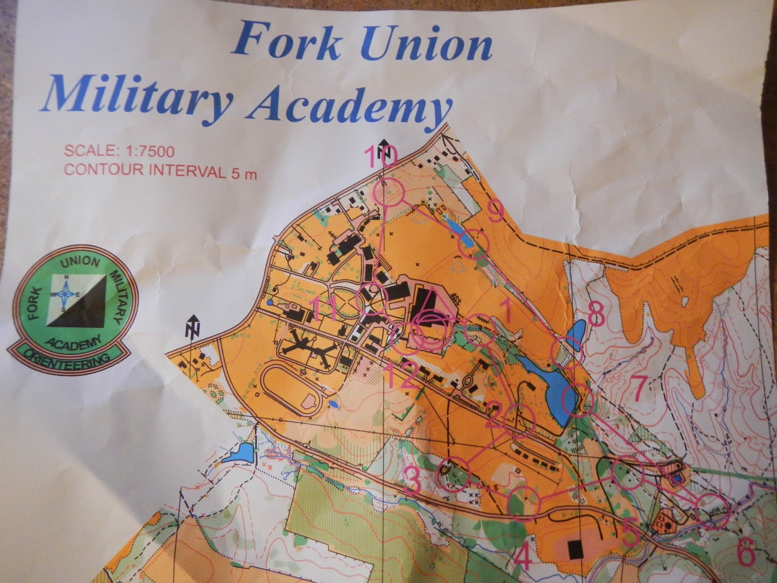
The topographic map is pretty detailed, with each flag location marked with a number and a circle, the course essentially following a circuit hike of a couple of miles.  The distance turned out to be 2.9 miles in my case, including some detours and a bit of wandering trying to find a few of the flags.

Here is a close up showing where flags #1 and #2 on the course that I did were located, and also #12 at the end:

Does this look like Virginia to you?  Not to me!  The snow cover was pretty much uniform, and was just a few inches deep, having compressed considerably over the last few days.  Temperatures were in the low or mid-twenties during my walk, and have rarely been above 25-35 for the past 12 days.

This was one of the prettiest spots during the entire orienteering course, with a lovely little stream flowing along.

Here is an example of a marker, each of which has a number that you compare with the list on the back of your map to make sure that you are at the right one - since it is easy to get confused, and there are four different levels of course to cover.  Note the hole punch hanging under the bag.  This flag was in the middle of soggy little wetland.

This is actually a small lake, totally frozen over.  We don't see a lot of this down this way, but when temperatures stay below freezing most of a time for a while, the laws of physics are going to be obeyed.

I enjoyed being outside in the fresh air today, and working on something challenging.  As it turned out, I only needed to use my compass a couple of times, because the map was so detailed.  I don't know if the snow made this easier or more difficult.  It made walking harder, but at the same time, there were lots of tracks that sometimes gave directional clues.  In any event, it was a fun and somewhat challenging way to start the 2015 hiking season out.  My goal is to hike 200 miles this year, so I still have 197.1 to go!

Monday, January 20, 2014

Bright Hope Trail, Pocahontas State Park

Thursday at work, my hiking buddy Hawkeye suggested that a few of us go for a hike Sunday (yesterday).  So we agreed to meet up at 11:00 at Pocahontas State Park, southwest of Richmond.
At the parking lot, there was a guy and his five Samoyed sled dogs getting ready for a wheeled sled ride along the trails.  How those dogs could bark!  They were so excited, and deafening.
Hawkeye selected our route, the Bright Hope Trail, which made for a pleasant and easy 5.4 mile hike.  It was a good first hike of 2014.  We started and ended at the orange star and walked counter-clockwise.
You can see that while there was some uphill and downhill, it was pretty minor with total elevation loss and gain of less than 400 feet.  Plus the trail was nicely graded and smooth, with no roots or rocks to trip over.
This was my first chance to try my new trekking poles.  The photo shows one folded up, with is a big reason that I wanted this pair.  They will easily fold up into a pack or suitcase.  They don't have shock absorbency, but I really liked them.
My hiking comrades, Hawkeye and Larry, pose near the start of our hike through the Piedmont forests of Virginia on a beautiful winter day.
There is an old cemetery along the way, the Gill-Dance Cemetery.  It was sad to see tombstones of so many very young children, many under six months of age.
I laughed when I saw an old man in this tree (with a distorted nose).  I could see an eye and mouth.  It reminded me of the ents in the "Lord of the Rings" movies.
Most of the hike was forest just like this.
At the end of this hike, Hawkeye suggested we do another shorter hike of about 2.5 miles around Beaver Lake, but I foolishly declined.  I wanted to get home to watch the AFC Championship Game, which I thought was going to be a great game and a classic quarterback duel.  I was wrong.  It was a one-sided game and only one of the quarterbacks played great.  I was really annoyed with myself to not go on the second hike.  But anyway, I had fun hiking the Bright Hope Trail on a pretty day.

Sunday, June 21, 2009

Ticked Off in Amelia WMA!

It isn't often that I quit on a very doable hike, but that happened today in Amelia Wildlife Management Area, run by the Virginia Department of Game and Inland Fisheries. My original goal was to do a 6 mile loop. There are not maintained trails per se, just old woods roads and other such pathways going through woods and fields, often quite grown up with tall grass and brush. So it is a bit of a challenge to find one's way on this hike.

I got the idea of going here because the ODATC was going to do this hike yesterday, but cancelled it. My original intent was to go along with them, and after it was canceled, I decided to go by myself today, having never been there. There is a nice sized lake that the hike skirts the shore of, and the potential promise of seeing some wildlife. And I did see wildlife, tons of it, mostly with eight legs and in a very friendly mood. After going about a mile and picking at least two dozen ticks from my clothing, I decided to try this one in winter some time and turned around. I continued picking a few ticks off all the way back to the car, and even just before jumping in the shower at home!

I heard oven birds and cardinals calling, saw an unidentified yellowish warbler, and several interesting kinds of mushrooms. I also saw a wasp dragging a large wolf spider that she had paralyzed for her progency to get their start in life from. But the dominant wildlife were ticks - lots and lots of ticks!
-
Here are some photos from my short, tick plagued hike:
Very cool yellowish-orange mushroom
There was no marked trail. Some of the track was fairly open like this;
Other parts of it were grassy and brushy, like this, with plenty of ticks to go around
Interesting tree
Not sure what type of flower this is, maybe some type of a black-eyed Susan
This mushroom was so pretty, and this little area of the forest floor almost looked like it was on fire from it
Muddy stream on the way to Amelia Lake, and from there to the nearby Appomattox River
Queen Anne's Lace (or similar)